Gudiyatham elevation
Gudiyatham (Tamil Nadu, Vellore), India elevation is 280 meters and Gudiyatham elevation in feet is 919 ft above sea level [src 1]. Gudiyatham is a populated place (feature code) with elevation that is 13 meters (43 ft) smaller than average city elevation in India.
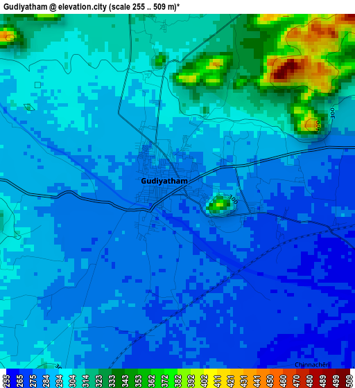
Below is the Elevation map of Gudiyatham, which displays elevation range with different colors. Scale of the first map is from 255 to 509 m (837 to 1670 ft) with average elevation of 294.9 meters (=968 ft) [note 1]
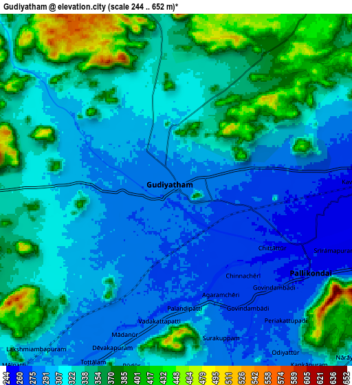
These maps also provides idea of topography and contour of this city, they are displayed at different zoom levels. More info about maps, scale and edge coordinates you can find below images.
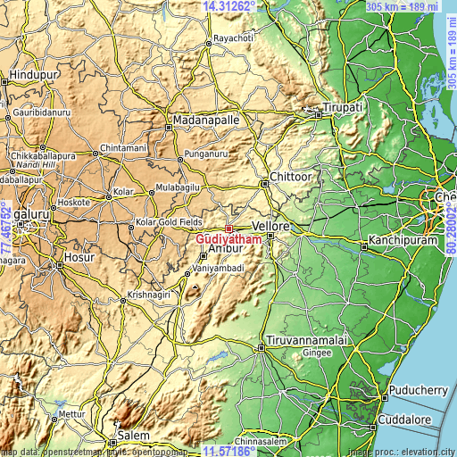
| \ | Map #1 | Map #2 | Topo.Map |
| Scale [m] | 255..509 m | 244..652 m | × |
| Scale [ft] | 837..1670 ft | 801..2139 ft | × |
| Average | 294.9 m = 968 ft | 326.6 m = 1072 ft | × |
| Width | 9.52 km = 5.9 mi | 19.05 km = 11.8 mi | 304.7 km = 189.3 mi |
| Height | 9.52 km = 5.9 mi | 19.05 km = 11.8 mi | 304.8 km = 189.4 mi |
| ↑Max Latitude | 12.988835° | 13.031652° | 14.31262° |
| Latitude at center | 12.94601° | 12.94601° | 12.94601° |
| ↓Min Latitude | 12.903178° | 12.860339° | 11.57186° |
| ← Min Longitude | 78.829825° | 78.785879° | 77.46752° |
| Longitude center | 78.87377° | 78.87377° | 78.87377° |
| →Max Longitude | 78.917715° | 78.961661° | 80.28002° |
Nearby cities:
Cities around Gudiyatham sort by population:
• Vellore elevation 218 m
28.2 km,  96°
96°
• Ambur 322 m
24.2 km,  224°
224°
• Vaniyambadi 352 m
40.3 km, 223°
• Peranāmpattu 369 m
16.8 km,  265°
265°
• Palmaner 675 m
31.4 km,  334°
334°
• Rāmāpuram 283 m
37.8 km,  62°
62°
• Pallikondai 262 m
8.7 km,  121°
121°
• Alangāyam 505 m
38.3 km,  200°
200°
• Kātpādi 213 m
29.6 km,  84°
84°
• Pudūr 234 m
29.8 km, 78°
• Odugattūr 333 m
19.8 km,  177°
177°
• Chittoor 334 m
38 km,  39°
39°
Multilingual:
 En español:
Gudiyatham elevación 280 m.
 En France:
Gudiyatham élévation 280 m.
 Auf Deutsch:
Gudiyatham höhe über dem Meeresspiegel ist 280 m.

Sources and notes:
- [note 1] Map square and city borders are not equal. Map elevation data is calculated only from area inside that square.
- [src 1] Elevation data from geonames database provided with same terms of usage.
- [src 2] The elevation map of Gudiyatham is generated using elevation data from NASA's 3 arcsec (90m) resolution SRTM data.
- [src 3] Base (background) map © OpenStreetMap contributors tiles are generated by Geofabrik and OpenTopoMap.
Copyright & License:
This Gudiyatham Elevation Map is licensed under CC BY-SA. You may reuse any part from this page, if you give a proper credit by linking to this URL:
 More info on terms of use page.