Gunupur elevation
Gunupur (Odisha, Rayagada), India elevation is 87 meters and Gunupur elevation in feet is 285 ft above sea level [src 1]. Gunupur is a populated place (feature code) with elevation that is 206 meters (676 ft) smaller than average city elevation in India.
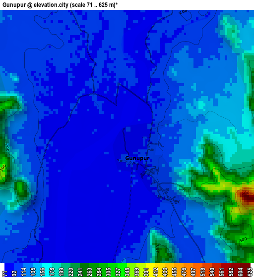
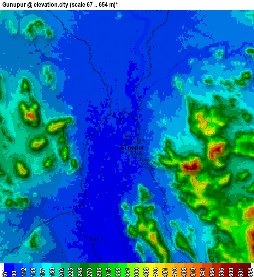
Below is the Elevation map of Gunupur, which displays elevation range with different colors. Scale of the first map is from 71 to 625 m (233 to 2051 ft) with average elevation of 123.1 meters (=404 ft) [note 1]
These maps also provides idea of topography and contour of this city, they are displayed at different zoom levels. More info about maps, scale and edge coordinates you can find below images.
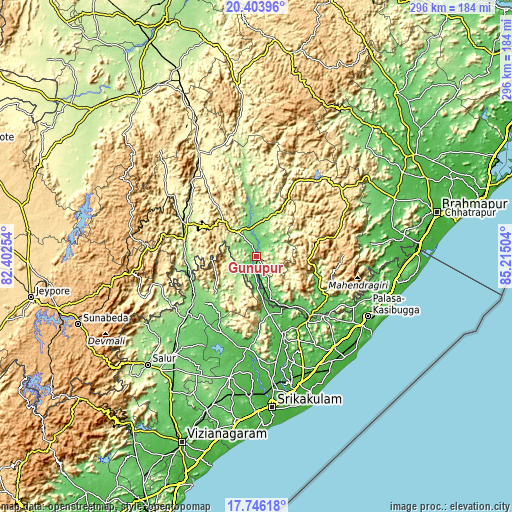
| \ | Map #1 | Map #2 | Topo.Map |
| Scale [m] | 71..625 m | 67..654 m | × |
| Scale [ft] | 233..2051 ft | 220..2146 ft | × |
| Average | 123.1 m = 404 ft | 160.7 m = 527 ft | × |
| Width | 9.24 km = 5.7 mi | 18.47 km = 11.5 mi | 295.5 km = 183.6 mi |
| Height | 9.24 km = 5.7 mi | 18.47 km = 11.5 mi | 295.5 km = 183.6 mi |
| ↑Max Latitude | 19.121926° | 19.163441° | 20.40396° |
| Latitude at center | 19.0804° | 19.0804° | 19.0804° |
| ↓Min Latitude | 19.038864° | 18.997317° | 17.74618° |
| ← Min Longitude | 83.764845° | 83.720899° | 82.40254° |
| Longitude center | 83.80879° | 83.80879° | 83.80879° |
| →Max Longitude | 83.852735° | 83.896681° | 85.21504° |
Nearby cities:
Cities around Gunupur sort by population:
• Palāsa elevation 36 m
71.9 km,  118°
118°
• Bobbili 135 m
73.6 km,  220°
220°
• Pārvatipuram 128 m
52.1 km,  230°
230°
• Parlākimidi 71 m
44.4 km,  138°
138°
• Amudālavalasa 36 m
75.2 km,  172°
172°
• Pālkonda 52 m
53.3 km,  186°
186°
• Rāzām 72 m
71.9 km, 192°
• Tekkali 39 m
69.3 km, 139°
• Narasannapeta 31 m
78.1 km,  161°
161°
• Mandasa 44 m
72.7 km,  108°
108°
• Gudāri 127 m
29.9 km,  354°
354°
• Ganguvāda 220 m
56.3 km, 144°
Multilingual:
 En español:
Gunupur elevación 87 m.
 En France:
Gunupur élévation 87 m.


Sources and notes:
- [note 1] Map square and city borders are not equal. Map elevation data is calculated only from area inside that square.
- [src 1] Elevation data from geonames database provided with same terms of usage.
- [src 2] The elevation map of Gunupur is generated using elevation data from NASA's 3 arcsec (90m) resolution SRTM data.
- [src 3] Base (background) map © OpenStreetMap contributors tiles are generated by Geofabrik and OpenTopoMap.
Copyright & License:
This Gunupur Elevation Map is licensed under CC BY-SA. You may reuse any part from this page, if you give a proper credit by linking to this URL:
 More info on terms of use page.