Jawhār elevation
Jawhār (Maharashtra, Thane), India elevation is 462 meters and Jawhār elevation in feet is 1516 ft above sea level [src 1]. Jawhār is a populated place (feature code) with elevation that is 169 meters (554 ft) bigger than average city elevation in India.
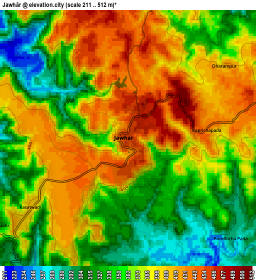
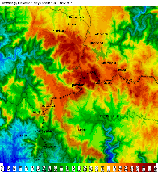
Below is the Elevation map of Jawhār, which displays elevation range with different colors. Scale of the first map is from 211 to 512 m (692 to 1680 ft) with average elevation of 374.2 meters (=1228 ft) [note 1]
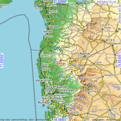
These maps also provides idea of topography and contour of this city, they are displayed at different zoom levels. More info about maps, scale and edge coordinates you can find below images.
| \ | Map #1 | Map #2 | Topo.Map |
| Scale [m] | 211..512 m | 104..512 m | × |
| Scale [ft] | 692..1680 ft | 341..1680 ft | × |
| Average | 374.2 m = 1228 ft | 323 m = 1060 ft | × |
| Width | 9.19 km = 5.7 mi | 18.38 km = 11.4 mi | 294 km = 182.7 mi |
| Height | 9.19 km = 5.7 mi | 18.38 km = 11.4 mi | 294 km = 182.7 mi |
| ↑Max Latitude | 19.953443° | 19.994745° | 21.22868° |
| Latitude at center | 19.91213° | 19.91213° | 19.91213° |
| ↓Min Latitude | 19.870807° | 19.829472° | 18.58453° |
| ← Min Longitude | 73.182845° | 73.138899° | 71.82054° |
| Longitude center | 73.22679° | 73.22679° | 73.22679° |
| →Max Longitude | 73.270735° | 73.314681° | 74.63304° |
Nearby cities:
Cities around Jawhār sort by population:
• Pālghar elevation 17 m
53.9 km,  243°
243°
• Dāhānu 8 m
54.1 km,  276°
276°
• Igatpuri 590 m
42.6 km,  124°
124°
• Āmli 39 m
46.7 km,  332°
332°
• Silvassa 37 m
46.8 km, 329°
• Ghoti Budrukh 593 m
47.3 km, 117°
• Boisar 16 m
50.7 km,  256°
256°
• Vāda 60 m
29.9 km,  195°
195°
• Shāhāpur 59 m
52.2 km,  168°
168°
• Trimbak 724 m
31.7 km,  85°
85°
• Manor 19 m
39.2 km, 237°
• Dadra 37 m
53.4 km, 329°
Multilingual:
 En español:
Jawhār elevación 462 m.
 En France:
Jawhār élévation 462 m.


Sources and notes:
- [note 1] Map square and city borders are not equal. Map elevation data is calculated only from area inside that square.
- [src 1] Elevation data from geonames database provided with same terms of usage.
- [src 2] The elevation map of Jawhār is generated using elevation data from NASA's 3 arcsec (90m) resolution SRTM data.
- [src 3] Base (background) map © OpenStreetMap contributors tiles are generated by Geofabrik and OpenTopoMap.
Copyright & License:
This Jawhār Elevation Map is licensed under CC BY-SA. You may reuse any part from this page, if you give a proper credit by linking to this URL:
 More info on terms of use page.