Jaynagar elevation
Jaynagar (Bihar, Madhubani), India elevation is 76 meters and Jaynagar elevation in feet is 249 ft above sea level [src 1]. Jaynagar is a populated place (feature code) with elevation that is 217 meters (712 ft) smaller than average city elevation in India.
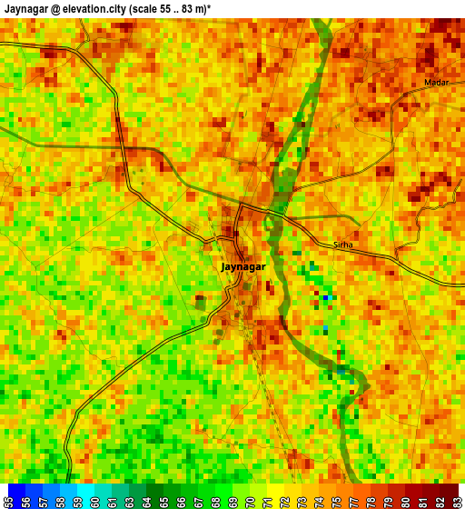
Below is the Elevation map of Jaynagar, which displays elevation range with different colors. Scale of the first map is from 55 to 83 m (180 to 272 ft) with average elevation of 72.9 meters (=239 ft) [note 1]
These maps also provides idea of topography and contour of this city, they are displayed at different zoom levels. More info about maps, scale and edge coordinates you can find below images.
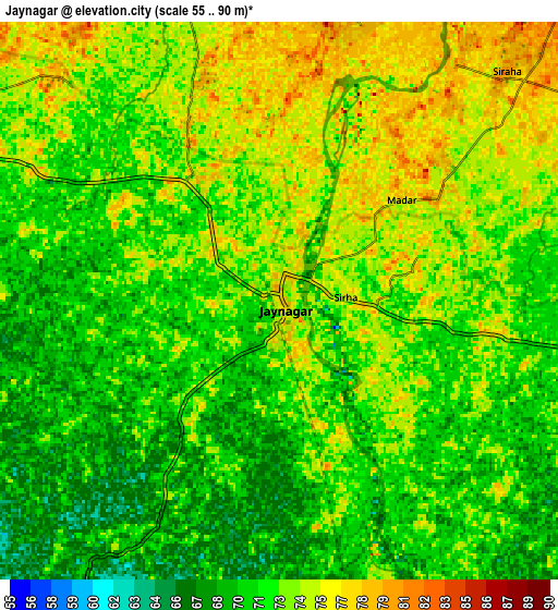
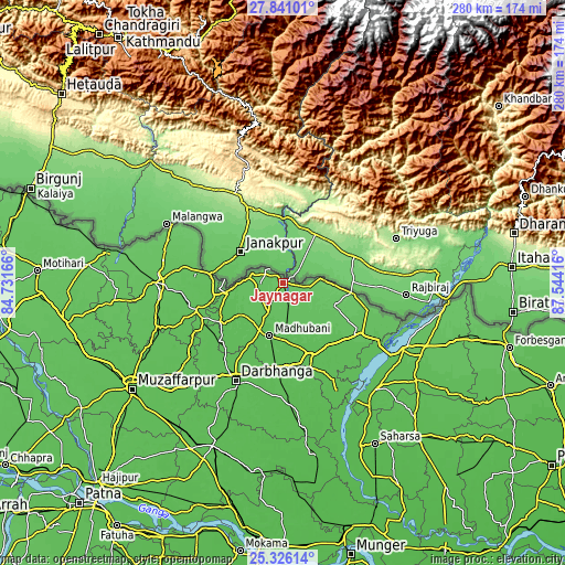
| \ | Map #1 | Map #2 | Topo.Map |
| Scale [m] | 55..83 m | 55..90 m | × |
| Scale [ft] | 180..272 ft | 180..295 ft | × |
| Average | 72.9 m = 239 ft | 72.3 m = 237 ft | × |
| Width | 8.74 km = 5.4 mi | 17.48 km = 10.9 mi | 279.6 km = 173.7 mi |
| Height | 8.74 km = 5.4 mi | 17.48 km = 10.9 mi | 279.6 km = 173.7 mi |
| ↑Max Latitude | 26.62977° | 26.669047° | 27.84101° |
| Latitude at center | 26.59048° | 26.59048° | 26.59048° |
| ↓Min Latitude | 26.551176° | 26.511859° | 25.32614° |
| ← Min Longitude | 86.093965° | 86.050019° | 84.73166° |
| Longitude center | 86.13791° | 86.13791° | 86.13791° |
| →Max Longitude | 86.181855° | 86.225801° | 87.54416° |
Nearby cities:
Cities around Jaynagar sort by population:
• Darbhanga elevation 58 m
54.3 km,  206°
206°
• Madhubani 61 m
27.1 km,  194°
194°
• Supaul 56 m
69.8 km,  139°
139°
• Sītāmarhi 70 m
64.4 km,  270°
270°
• Jhanjhārpur 56 m
38.9 km,  158°
158°
• Sheohar 71 m
84.4 km,  264°
264°
• Belsand 67 m
75.1 km, 257°
• Bīrpur 81 m
87.4 km,  96°
96°
• Nirmāli 58 m
54.1 km,  124°
124°
• Dumra 70 m
61.5 km, 267°
• Pupri 63 m
45.3 km,  252°
252°
• Bhagirathpur 60 m
36.5 km, 191°
Multilingual:
 En español:
Jaynagar elevación 76 m.
 En France:
Jaynagar élévation 76 m.


Sources and notes:
- [note 1] Map square and city borders are not equal. Map elevation data is calculated only from area inside that square.
- [src 1] Elevation data from geonames database provided with same terms of usage.
- [src 2] The elevation map of Jaynagar is generated using elevation data from NASA's 3 arcsec (90m) resolution SRTM data.
- [src 3] Base (background) map © OpenStreetMap contributors tiles are generated by Geofabrik and OpenTopoMap.
Copyright & License:
This Jaynagar Elevation Map is licensed under CC BY-SA. You may reuse any part from this page, if you give a proper credit by linking to this URL:
 More info on terms of use page.