Kāgal elevation
Kāgal (Maharashtra, Kolhapur), India elevation is 565 meters and Kāgal elevation in feet is 1854 ft above sea level [src 1]. Kāgal is a populated place (feature code) with elevation that is 272 meters (892 ft) bigger than average city elevation in India.
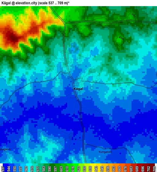
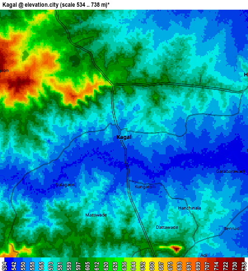
Below is the Elevation map of Kāgal, which displays elevation range with different colors. Scale of the first map is from 537 to 709 m (1762 to 2326 ft) with average elevation of 570.7 meters (=1872 ft) [note 1]
These maps also provides idea of topography and contour of this city, they are displayed at different zoom levels. More info about maps, scale and edge coordinates you can find below images.
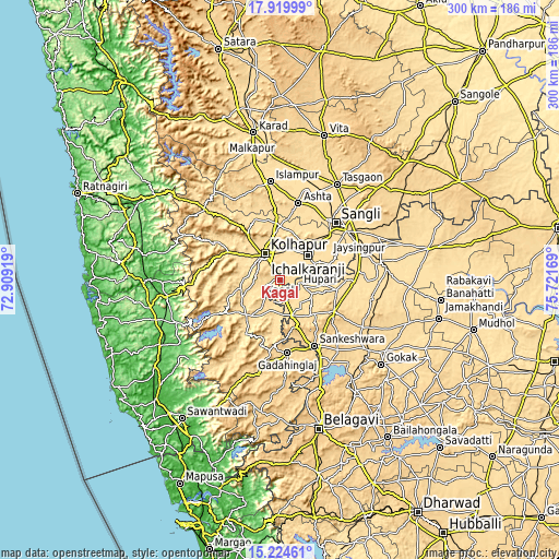
| \ | Map #1 | Map #2 | Topo.Map |
| Scale [m] | 537..709 m | 534..738 m | × |
| Scale [ft] | 1762..2326 ft | 1752..2421 ft | × |
| Average | 570.7 m = 1872 ft | 579.8 m = 1902 ft | × |
| Width | 9.37 km = 5.8 mi | 18.73 km = 11.6 mi | 299.7 km = 186.2 mi |
| Height | 9.37 km = 5.8 mi | 18.73 km = 11.6 mi | 299.7 km = 186.2 mi |
| ↑Max Latitude | 16.619134° | 16.661239° | 17.91999° |
| Latitude at center | 16.57702° | 16.57702° | 16.57702° |
| ↓Min Latitude | 16.534897° | 16.492764° | 15.22461° |
| ← Min Longitude | 74.271495° | 74.227549° | 72.90919° |
| Longitude center | 74.31544° | 74.31544° | 74.31544° |
| →Max Longitude | 74.359385° | 74.403331° | 75.72169° |
Nearby cities:
Cities around Kāgal sort by population:
• Kolhāpur elevation 559 m
15.9 km,  325°
325°
• Ichalkaranji 561 m
20 km,  50°
50°
• Nipāni 608 m
21.1 km,  160°
160°
• Jaisingpur 558 m
33.7 km, 48°
• Chikodi 638 m
33.2 km,  119°
119°
• Sankeshwar 638 m
39.8 km,  153°
153°
• Gadhinglaj 647 m
39.5 km,  174°
174°
• Sadalgi 548 m
23.2 km,  95°
95°
• Kurandvād 546 m
31.4 km,  67°
67°
• Kodoli 566 m
35.8 km,  338°
338°
• Murgūd 569 m
24.1 km,  213°
213°
• Panhāla 947 m
34.1 km,  320°
320°
Multilingual:
 En español:
Kāgal elevación 565 m.
 En France:
Kāgal élévation 565 m.


Sources and notes:
- [note 1] Map square and city borders are not equal. Map elevation data is calculated only from area inside that square.
- [src 1] Elevation data from geonames database provided with same terms of usage.
- [src 2] The elevation map of Kāgal is generated using elevation data from NASA's 3 arcsec (90m) resolution SRTM data.
- [src 3] Base (background) map © OpenStreetMap contributors tiles are generated by Geofabrik and OpenTopoMap.
Copyright & License:
This Kāgal Elevation Map is licensed under CC BY-SA. You may reuse any part from this page, if you give a proper credit by linking to this URL:
 More info on terms of use page.