Kalpatta elevation
Kalpatta (Kerala, Wayanad), India elevation is 755 meters and Kalpatta elevation in feet is 2477 ft above sea level [src 1]. Kalpatta is a populated place (feature code) with elevation that is 462 meters (1516 ft) bigger than average city elevation in India.
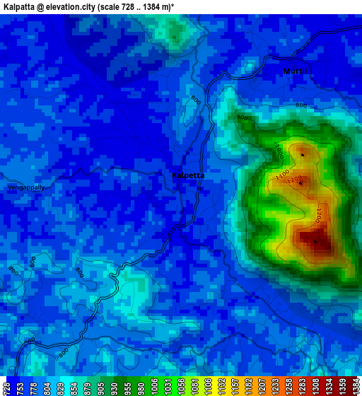
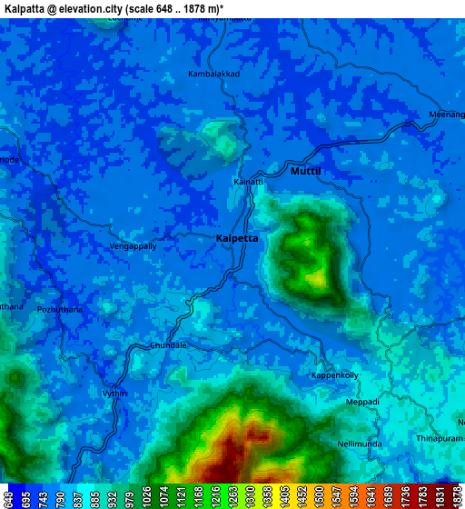
Below is the Elevation map of Kalpatta, which displays elevation range with different colors. Scale of the first map is from 728 to 1384 m (2388 to 4541 ft) with average elevation of 814.2 meters (=2671 ft) [note 1]
These maps also provides idea of topography and contour of this city, they are displayed at different zoom levels. More info about maps, scale and edge coordinates you can find below images.
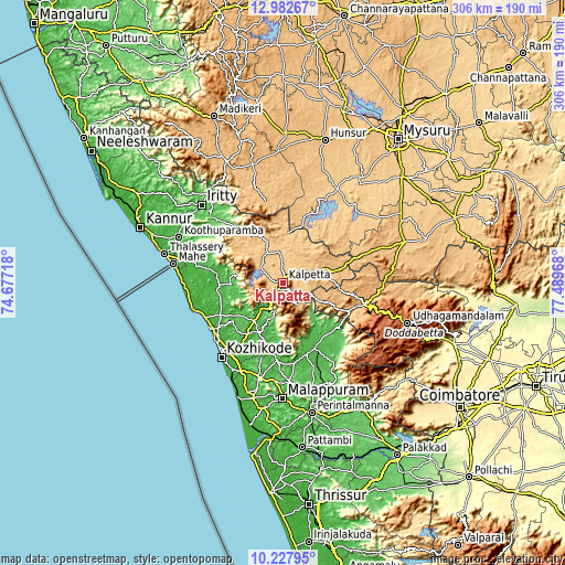
| \ | Map #1 | Map #2 | Topo.Map |
| Scale [m] | 728..1384 m | 648..1878 m | × |
| Scale [ft] | 2388..4541 ft | 2126..6161 ft | × |
| Average | 814.2 m = 2671 ft | 826.3 m = 2711 ft | × |
| Width | 9.57 km = 5.9 mi | 19.15 km = 11.9 mi | 306.3 km = 190.3 mi |
| Height | 9.57 km = 5.9 mi | 19.15 km = 11.9 mi | 306.3 km = 190.3 mi |
| ↑Max Latitude | 11.651753° | 11.694789° | 12.98267° |
| Latitude at center | 11.60871° | 11.60871° | 11.60871° |
| ↓Min Latitude | 11.56566° | 11.522604° | 10.22795° |
| ← Min Longitude | 76.039485° | 75.995539° | 74.67718° |
| Longitude center | 76.08343° | 76.08343° | 76.08343° |
| →Max Longitude | 76.127375° | 76.171321° | 77.48968° |
Nearby cities:
Cities around Kalpatta sort by population:
• Kozhikode elevation 9 m
52 km,  219°
219°
• Manjeri 46 m
54.5 km,  175°
175°
• Nādāpuram 24 m
47.4 km,  280°
280°
• Kunnamangalam 29 m
40.6 km,  213°
213°
• Ferokh 25 m
54.5 km, 208°
• Mavoor 34 m
42.2 km, 205°
• Naduvannūr 20 m
36.2 km,  248°
248°
• Iringal 25 m
51.1 km,  263°
263°
• Perya 742 m
35.3 km,  315°
315°
• Naduvattam 1855 m
52.1 km,  105°
105°
• Panamaram 728 m
14.7 km,  355°
355°
• Kannavam 42 m
52.8 km,  299°
299°
Multilingual:
 En español:
Kalpatta elevación 755 m.
 En France:
Kalpatta élévation 755 m.
 Auf Deutsch:
Kalpatta höhe über dem Meeresspiegel ist 755 m.

Sources and notes:
- [note 1] Map square and city borders are not equal. Map elevation data is calculated only from area inside that square.
- [src 1] Elevation data from geonames database provided with same terms of usage.
- [src 2] The elevation map of Kalpatta is generated using elevation data from NASA's 3 arcsec (90m) resolution SRTM data.
- [src 3] Base (background) map © OpenStreetMap contributors tiles are generated by Geofabrik and OpenTopoMap.
Copyright & License:
This Kalpatta Elevation Map is licensed under CC BY-SA. You may reuse any part from this page, if you give a proper credit by linking to this URL:
 More info on terms of use page.