Kāngar elevation
Kāngar (Himachal Pradesh, Kāngra), India elevation is 697 meters and Kāngar elevation in feet is 2287 ft above sea level [src 1]. Kāngar is a populated place (feature code) with elevation that is 404 meters (1325 ft) bigger than average city elevation in India.
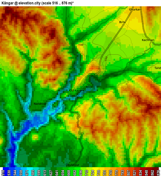
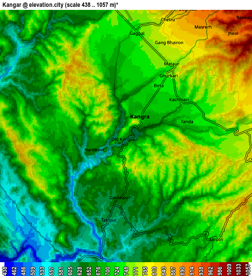
Below is the Elevation map of Kāngar, which displays elevation range with different colors. Scale of the first map is from 516 to 876 m (1693 to 2874 ft) with average elevation of 705.4 meters (=2314 ft) [note 1]
These maps also provides idea of topography and contour of this city, they are displayed at different zoom levels. More info about maps, scale and edge coordinates you can find below images.
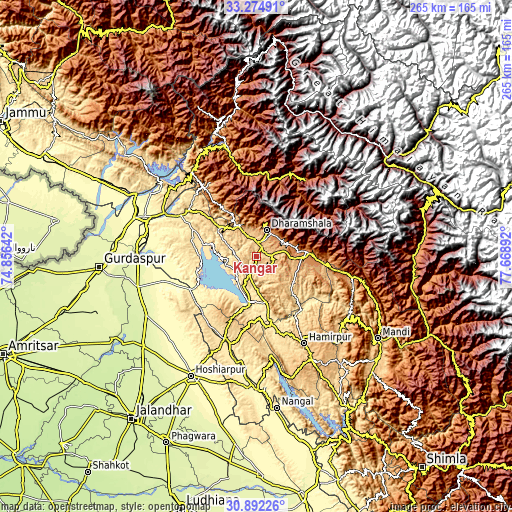
| \ | Map #1 | Map #2 | Topo.Map |
| Scale [m] | 516..876 m | 438..1057 m | × |
| Scale [ft] | 1693..2874 ft | 1437..3468 ft | × |
| Average | 705.4 m = 2314 ft | 709.8 m = 2329 ft | × |
| Width | 8.28 km = 5.1 mi | 16.56 km = 10.3 mi | 264.9 km = 164.6 mi |
| Height | 8.28 km = 5.1 mi | 16.56 km = 10.3 mi | 264.9 km = 164.6 mi |
| ↑Max Latitude | 32.128573° | 32.165781° | 33.27491° |
| Latitude at center | 32.09135° | 32.09135° | 32.09135° |
| ↓Min Latitude | 32.054112° | 32.016859° | 30.89226° |
| ← Min Longitude | 76.218725° | 76.174779° | 74.85642° |
| Longitude center | 76.26267° | 76.26267° | 76.26267° |
| →Max Longitude | 76.306615° | 76.350561° | 77.66892° |
Nearby cities:
Cities around Kāngar sort by population:
• Talwāra elevation 356 m
39.4 km,  244°
244°
• Dharamsala 1359 m
15.3 km,  20°
20°
• Yol 672 m
10.2 km,  322°
322°
• Tīra Sujānpur 565 m
36.7 km,  141°
141°
• Nagrota 457 m
16.6 km,  256°
256°
• Jawāla Mukhi 520 m
24.7 km,  167°
167°
• Kotla 608 m
27.9 km,  309°
309°
• Nādaun 478 m
35.1 km, 167°
• Daulatpur 540 m
42.3 km,  217°
217°
• Dera Gopipur 445 m
24 km,  189°
189°
• Pālampur 1355 m
27.8 km,  84°
84°
• Daulatpur 646 m
3.9 km,  182°
182°
Multilingual:
 En español:
Kāngar elevación 697 m.
 En France:
Kāngar élévation 697 m.


Sources and notes:
- [note 1] Map square and city borders are not equal. Map elevation data is calculated only from area inside that square.
- [src 1] Elevation data from geonames database provided with same terms of usage.
- [src 2] The elevation map of Kāngar is generated using elevation data from NASA's 3 arcsec (90m) resolution SRTM data.
- [src 3] Base (background) map © OpenStreetMap contributors tiles are generated by Geofabrik and OpenTopoMap.
Copyright & License:
This Kāngar Elevation Map is licensed under CC BY-SA. You may reuse any part from this page, if you give a proper credit by linking to this URL:
 More info on terms of use page.