Kuchāman elevation
Kuchāman (Rajasthan, Nāgaur), India elevation is 396 meters and Kuchāman elevation in feet is 1299 ft above sea level [src 1]. Kuchāman is a populated place (feature code) with elevation that is 103 meters (338 ft) bigger than average city elevation in India.
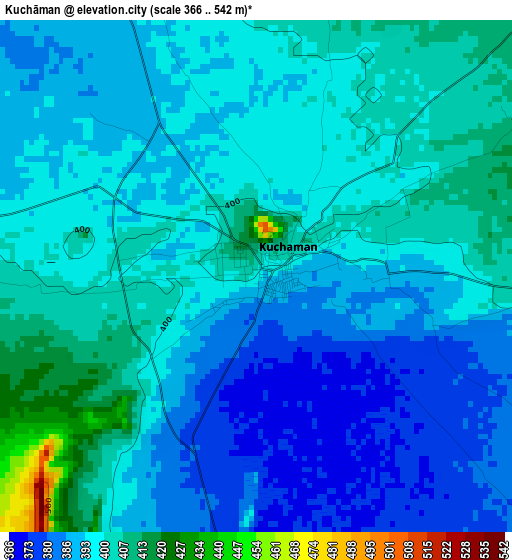
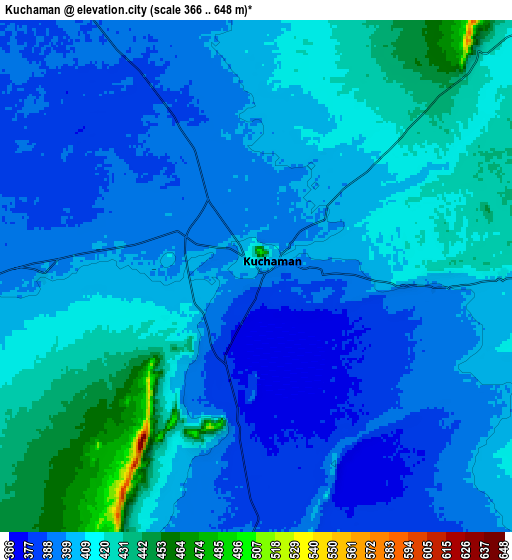
Below is the Elevation map of Kuchāman, which displays elevation range with different colors. Scale of the first map is from 366 to 542 m (1201 to 1778 ft) with average elevation of 394.7 meters (=1295 ft) [note 1]
These maps also provides idea of topography and contour of this city, they are displayed at different zoom levels. More info about maps, scale and edge coordinates you can find below images.
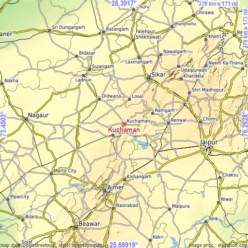
| \ | Map #1 | Map #2 | Topo.Map |
| Scale [m] | 366..542 m | 366..648 m | × |
| Scale [ft] | 1201..1778 ft | 1201..2126 ft | × |
| Average | 394.7 m = 1295 ft | 405 m = 1329 ft | × |
| Width | 8.7 km = 5.4 mi | 17.39 km = 10.8 mi | 278.3 km = 172.9 mi |
| Height | 8.7 km = 5.4 mi | 17.39 km = 10.8 mi | 278.3 km = 172.9 mi |
| ↑Max Latitude | 27.186547° | 27.225631° | 28.3917° |
| Latitude at center | 27.14745° | 27.14745° | 27.14745° |
| ↓Min Latitude | 27.108339° | 27.069214° | 25.88919° |
| ← Min Longitude | 74.812605° | 74.768659° | 73.4503° |
| Longitude center | 74.85655° | 74.85655° | 74.85655° |
| →Max Longitude | 74.900495° | 74.944441° | 76.2628° |
Nearby cities:
Cities around Kuchāman sort by population:
• Sīkar elevation 435 m
58.8 km,  28°
28°
• Makrāna 419 m
17.4 km,  228°
228°
• Dīdwāna 348 m
39.6 km,  315°
315°
• Rāmgarh 408 m
33.9 km,  70°
70°
• Losal 418 m
28.7 km,  11°
11°
• Sāmbhar 379 m
42.5 km,  128°
128°
• Phulera 385 m
48.8 km, 128°
• Nāwa 379 m
20.3 km, 134°
• Naraina 381 m
52.7 km,  138°
138°
• Parvatsar 434 m
30.4 km,  197°
197°
• Meethari Marwar 342 m
50.5 km,  340°
340°
• Jobner 399 m
56.1 km,  110°
110°
Multilingual:
 En español:
Kuchāman elevación 396 m.
 En France:
Kuchāman élévation 396 m.
 Auf Deutsch:
Kuchāman höhe über dem Meeresspiegel ist 396 m.

Sources and notes:
- [note 1] Map square and city borders are not equal. Map elevation data is calculated only from area inside that square.
- [src 1] Elevation data from geonames database provided with same terms of usage.
- [src 2] The elevation map of Kuchāman is generated using elevation data from NASA's 3 arcsec (90m) resolution SRTM data.
- [src 3] Base (background) map © OpenStreetMap contributors tiles are generated by Geofabrik and OpenTopoMap.
Copyright & License:
This Kuchāman Elevation Map is licensed under CC BY-SA. You may reuse any part from this page, if you give a proper credit by linking to this URL:
 More info on terms of use page.