Mandapeta elevation
Mandapeta (Andhra Pradesh, East Godāvari), India elevation is 17 meters and Mandapeta elevation in feet is 56 ft above sea level [src 1]. Mandapeta is a populated place (feature code) with elevation that is 276 meters (906 ft) smaller than average city elevation in India.
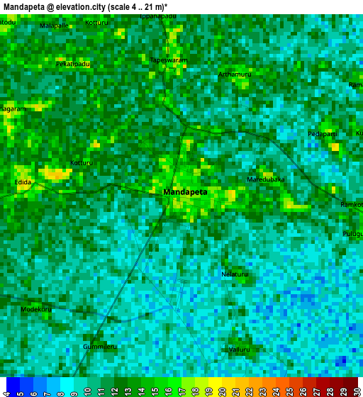
Below is the Elevation map of Mandapeta, which displays elevation range with different colors. Scale of the first map is from 4 to 21 m (13 to 69 ft) with average elevation of 10.8 meters (=35 ft) [note 1]
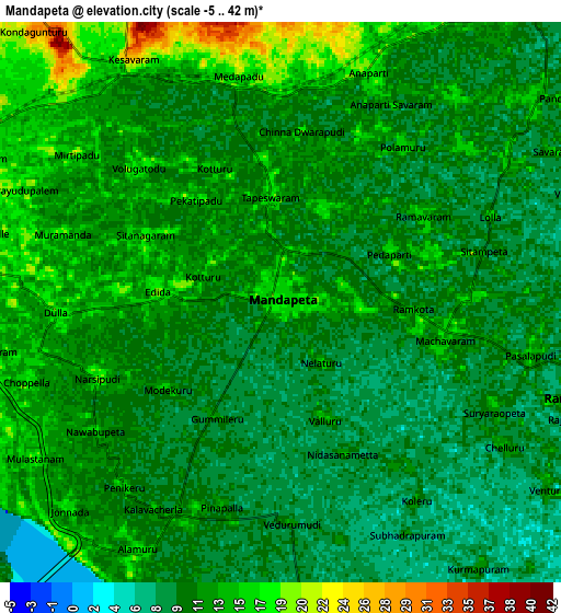
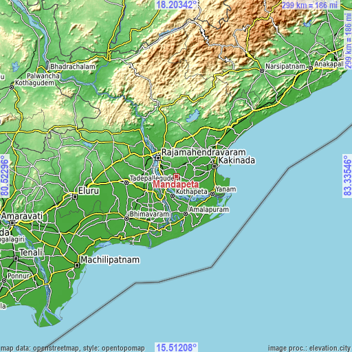
These maps also provides idea of topography and contour of this city, they are displayed at different zoom levels. More info about maps, scale and edge coordinates you can find below images.
| \ | Map #1 | Map #2 | Topo.Map |
| Scale [m] | 4..21 m | -5..42 m | × |
| Scale [ft] | 13..69 ft | -16..138 ft | × |
| Average | 10.8 m = 35 ft | 11.5 m = 38 ft | × |
| Width | 9.35 km = 5.8 mi | 18.7 km = 11.6 mi | 299.2 km = 185.9 mi |
| Height | 9.35 km = 5.8 mi | 18.7 km = 11.6 mi | 299.3 km = 186 mi |
| ↑Max Latitude | 16.904591° | 16.946633° | 18.20342° |
| Latitude at center | 16.86254° | 16.86254° | 16.86254° |
| ↓Min Latitude | 16.82048° | 16.77841° | 15.51208° |
| ← Min Longitude | 81.885265° | 81.841319° | 80.52296° |
| Longitude center | 81.92921° | 81.92921° | 81.92921° |
| →Max Longitude | 81.973155° | 82.017101° | 83.33546° |
Nearby cities:
Cities around Mandapeta sort by population:
• Rājahmundry elevation 34 m
22.6 km,  314°
314°
• Kākināda 6 m
34.6 km,  71°
71°
• Tanuku 15 m
29 km,  245°
245°
• Sāmalkot 19 m
34 km,  50°
50°
• Amalāpuram 11 m
32.6 km,  165°
165°
• Peddāpuram 38 m
32.6 km,  43°
43°
• Nidadavole 21 m
27.8 km,  279°
279°
• Rāmachandrapuram 12 m
11 km,  105°
105°
• Kovvūr 23 m
27.3 km, 308°
• Yanam 11 m
33.5 km,  115°
115°
• Penugonda 16 m
30.4 km,  220°
220°
• Ramanayyapeta 7 m
34.2 km, 74°
Multilingual:
 En español:
Mandapeta elevación 17 m.
 En France:
Mandapeta élévation 17 m.
 Auf Deutsch:
Mandapeta höhe über dem Meeresspiegel ist 17 m.

Sources and notes:
- [note 1] Map square and city borders are not equal. Map elevation data is calculated only from area inside that square.
- [src 1] Elevation data from geonames database provided with same terms of usage.
- [src 2] The elevation map of Mandapeta is generated using elevation data from NASA's 3 arcsec (90m) resolution SRTM data.
- [src 3] Base (background) map © OpenStreetMap contributors tiles are generated by Geofabrik and OpenTopoMap.
Copyright & License:
This Mandapeta Elevation Map is licensed under CC BY-SA. You may reuse any part from this page, if you give a proper credit by linking to this URL:
 More info on terms of use page.