Māngrol elevation
Māngrol (Rajasthan, Baran), India elevation is 242 meters and Māngrol elevation in feet is 794 ft above sea level [src 1]. Māngrol is a populated place (feature code) with elevation that is 51 meters (167 ft) smaller than average city elevation in India.
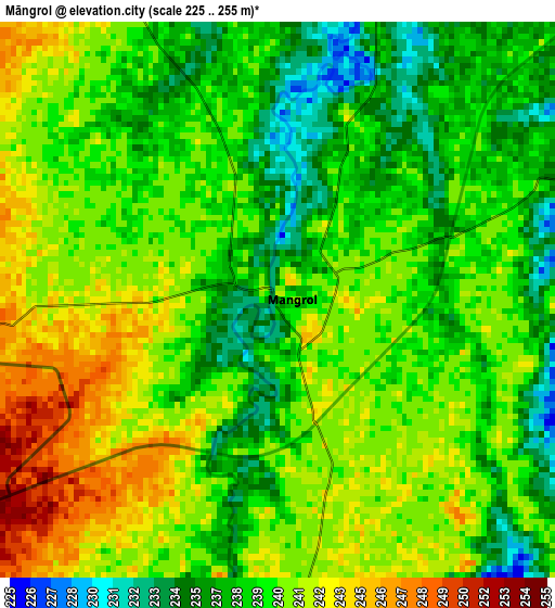
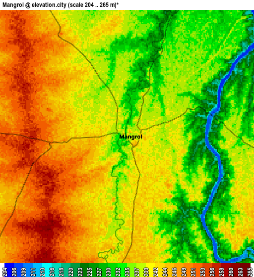
Below is the Elevation map of Māngrol, which displays elevation range with different colors. Scale of the first map is from 225 to 255 m (738 to 837 ft) with average elevation of 239.5 meters (=786 ft) [note 1]
These maps also provides idea of topography and contour of this city, they are displayed at different zoom levels. More info about maps, scale and edge coordinates you can find below images.
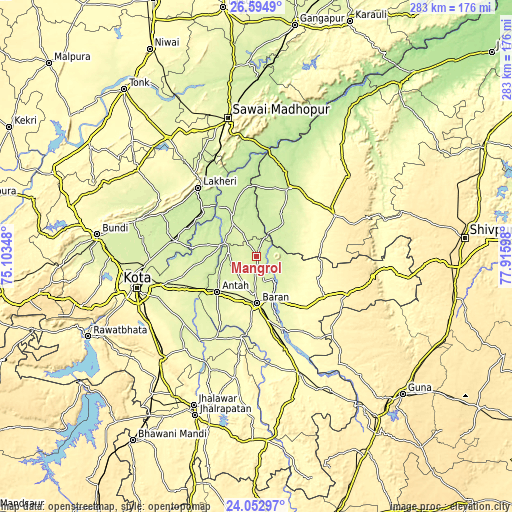
| \ | Map #1 | Map #2 | Topo.Map |
| Scale [m] | 225..255 m | 204..265 m | × |
| Scale [ft] | 738..837 ft | 669..869 ft | × |
| Average | 239.5 m = 786 ft | 239.9 m = 787 ft | × |
| Width | 8.83 km = 5.5 mi | 17.67 km = 11 mi | 282.6 km = 175.6 mi |
| Height | 8.83 km = 5.5 mi | 17.67 km = 11 mi | 282.6 km = 175.6 mi |
| ↑Max Latitude | 25.370324° | 25.410024° | 26.5949° |
| Latitude at center | 25.33061° | 25.33061° | 25.33061° |
| ↓Min Latitude | 25.290883° | 25.251144° | 24.05297° |
| ← Min Longitude | 76.465785° | 76.421839° | 75.10348° |
| Longitude center | 76.50973° | 76.50973° | 76.50973° |
| →Max Longitude | 76.553675° | 76.597621° | 77.91598° |
Nearby cities:
Cities around Māngrol sort by population:
• Kota elevation 267 m
69.4 km,  256°
256°
• Sawāi Mādhopur 257 m
78.8 km,  347°
347°
• Bārān 271 m
25.7 km,  178°
178°
• Sheopur 230 m
41.6 km,  26°
26°
• Anta 249 m
29.1 km,  226°
226°
• Lākheri 237 m
50.6 km,  318°
318°
• Chhabra 336 m
81.3 km,  155°
155°
• Keshorai Pātan 254 m
57.5 km,  265°
265°
• Sangod 266 m
50.2 km,  206°
206°
• Kāpren 240 m
44.5 km,  280°
280°
• Nainwa 301 m
82.4 km,  306°
306°
• Khānpur 290 m
67.5 km,  189°
189°
Multilingual:
 En español:
Māngrol elevación 242 m.
 En France:
Māngrol élévation 242 m.


Sources and notes:
- [note 1] Map square and city borders are not equal. Map elevation data is calculated only from area inside that square.
- [src 1] Elevation data from geonames database provided with same terms of usage.
- [src 2] The elevation map of Māngrol is generated using elevation data from NASA's 3 arcsec (90m) resolution SRTM data.
- [src 3] Base (background) map © OpenStreetMap contributors tiles are generated by Geofabrik and OpenTopoMap.
Copyright & License:
This Māngrol Elevation Map is licensed under CC BY-SA. You may reuse any part from this page, if you give a proper credit by linking to this URL:
 More info on terms of use page.