Mansar elevation
Mansar (Maharashtra, Nagpur Division), India elevation is 330 meters and Mansar elevation in feet is 1083 ft above sea level [src 1]. Mansar is a populated place (feature code) with elevation that is 37 meters (121 ft) bigger than average city elevation in India.
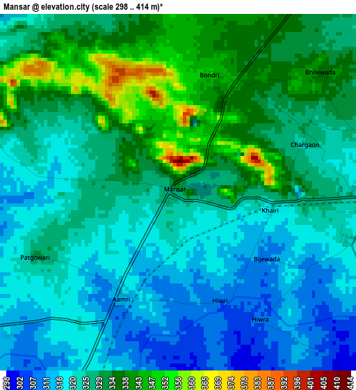
Below is the Elevation map of Mansar, which displays elevation range with different colors. Scale of the first map is from 298 to 414 m (978 to 1358 ft) with average elevation of 326.6 meters (=1072 ft) [note 1]
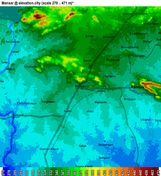
These maps also provides idea of topography and contour of this city, they are displayed at different zoom levels. More info about maps, scale and edge coordinates you can find below images.
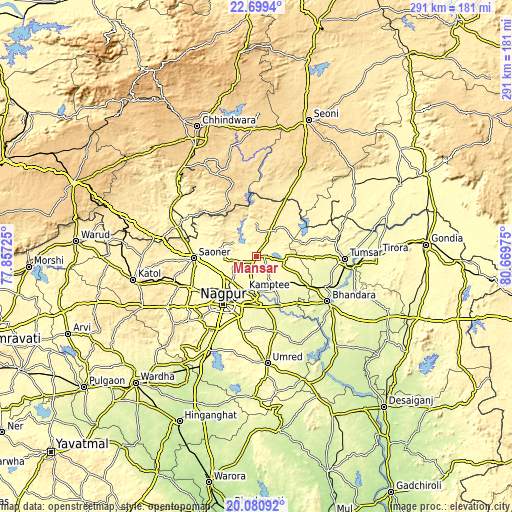
| \ | Map #1 | Map #2 | Topo.Map |
| Scale [m] | 298..414 m | 270..471 m | × |
| Scale [ft] | 978..1358 ft | 886..1545 ft | × |
| Average | 326.6 m = 1072 ft | 321.3 m = 1054 ft | × |
| Width | 9.1 km = 5.7 mi | 18.2 km = 11.3 mi | 291.1 km = 180.9 mi |
| Height | 9.1 km = 5.7 mi | 18.2 km = 11.3 mi | 291.2 km = 180.9 mi |
| ↑Max Latitude | 21.436931° | 21.47783° | 22.6994° |
| Latitude at center | 21.39602° | 21.39602° | 21.39602° |
| ↓Min Latitude | 21.355098° | 21.314164° | 20.08092° |
| ← Min Longitude | 79.219555° | 79.175609° | 77.85725° |
| Longitude center | 79.2635° | 79.2635° | 79.2635° |
| →Max Longitude | 79.307445° | 79.351391° | 80.66975° |
Nearby cities:
Cities around Mansar sort by population:
• Nagpur elevation 319 m
33.4 km,  213°
213°
• Bhandāra 262 m
47.3 km,  122°
122°
• Kāmthi 288 m
21.1 km,  198°
198°
• Saoner 328 m
35.4 km,  268°
268°
• Rāmtek 336 m
6.6 km,  90°
90°
• Kalmeshwar 334 m
40 km,  242°
242°
• Chicholi 291 m
46.1 km,  79°
79°
• Khāpa 315 m
29.3 km,  275°
275°
• Lodhīkheda 347 m
46.7 km,  296°
296°
• Kāndri 344 m
3 km,  26°
26°
• Mohpa 361 m
45.9 km,  257°
257°
• Korādi 307 m
23.2 km,  224°
224°
Multilingual:
 En español:
Mansar elevación 330 m.
 En France:
Mansar élévation 330 m.


Sources and notes:
- [note 1] Map square and city borders are not equal. Map elevation data is calculated only from area inside that square.
- [src 1] Elevation data from geonames database provided with same terms of usage.
- [src 2] The elevation map of Mansar is generated using elevation data from NASA's 3 arcsec (90m) resolution SRTM data.
- [src 3] Base (background) map © OpenStreetMap contributors tiles are generated by Geofabrik and OpenTopoMap.
Copyright & License:
This Mansar Elevation Map is licensed under CC BY-SA. You may reuse any part from this page, if you give a proper credit by linking to this URL:
 More info on terms of use page.