Mathura elevation
Mathura (Uttar Pradesh), India elevation is 181 meters and Mathura elevation in feet is 594 ft above sea level [src 1]. Mathura is a populated place (feature code) with elevation that is 112 meters (367 ft) smaller than average city elevation in India.
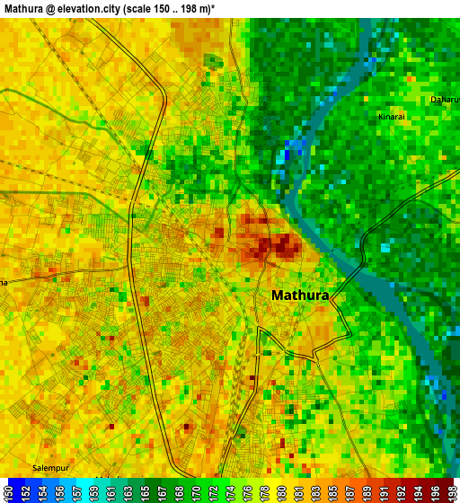
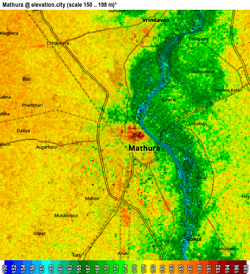
Below is the Elevation map of Mathura, which displays elevation range with different colors. Scale of the first map is from 150 to 198 m (492 to 650 ft) with average elevation of 175.6 meters (=576 ft) [note 1]
These maps also provides idea of topography and contour of this city, they are displayed at different zoom levels. More info about maps, scale and edge coordinates you can find below images.
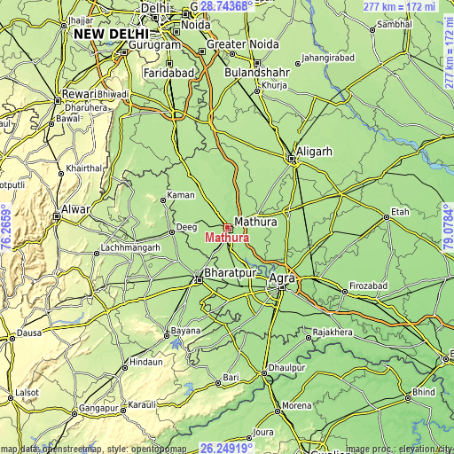
| \ | Map #1 | Map #2 | Topo.Map |
| Scale [m] | 150..198 m | 150..198 m | × |
| Scale [ft] | 492..650 ft | 492..650 ft | × |
| Average | 175.6 m = 576 ft | 176.8 m = 580 ft | × |
| Width | 8.67 km = 5.4 mi | 17.34 km = 10.8 mi | 277.4 km = 172.4 mi |
| Height | 8.67 km = 5.4 mi | 17.34 km = 10.8 mi | 277.4 km = 172.4 mi |
| ↑Max Latitude | 27.542472° | 27.58143° | 28.74368° |
| Latitude at center | 27.5035° | 27.5035° | 27.5035° |
| ↓Min Latitude | 27.464514° | 27.425515° | 26.24919° |
| ← Min Longitude | 77.628205° | 77.584259° | 76.2659° |
| Longitude center | 77.67215° | 77.67215° | 77.67215° |
| →Max Longitude | 77.716095° | 77.760041° | 79.0784° |
Nearby cities:
Cities around Mathura sort by population:
• Vrindāvan elevation 179 m
9 km,  15°
15°
• Chhāta 195 m
29.3 km,  326°
326°
• Govardhan 189 m
20.7 km,  267°
267°
• Rāya 185 m
13 km,  63°
63°
• Mursān 180 m
27.8 km,  72°
72°
• Baldev 179 m
18.3 km,  125°
125°
• Barsāna 188 m
33.3 km,  298°
298°
• Mahāban 179 m
10.6 km,  138°
138°
• Farah 179 m
22.2 km,  156°
156°
• Rādhākund 190 m
18 km,  277°
277°
• Beswān 182 m
25.4 km,  53°
53°
• Gokul 174 m
8.6 km,  146°
146°
Multilingual:
 En español:
Mathura elevación 181 m.
 En France:
Mathura élévation 181 m.


Sources and notes:
- [note 1] Map square and city borders are not equal. Map elevation data is calculated only from area inside that square.
- [src 1] Elevation data from geonames database provided with same terms of usage.
- [src 2] The elevation map of Mathura is generated using elevation data from NASA's 3 arcsec (90m) resolution SRTM data.
- [src 3] Base (background) map © OpenStreetMap contributors tiles are generated by Geofabrik and OpenTopoMap.
Copyright & License:
This Mathura Elevation Map is licensed under CC BY-SA. You may reuse any part from this page, if you give a proper credit by linking to this URL:
 More info on terms of use page.