Musāfir-Khāna elevation
Musāfir-Khāna (Uttar Pradesh, Sultānpur), India elevation is 107 meters and Musāfir-Khāna elevation in feet is 351 ft above sea level [src 1]. Musāfir-Khāna is a populated place (feature code) with elevation that is 186 meters (610 ft) smaller than average city elevation in India.
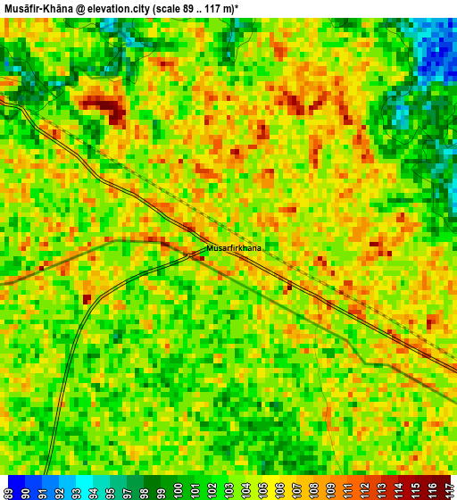
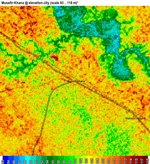
Below is the Elevation map of Musāfir-Khāna, which displays elevation range with different colors. Scale of the first map is from 89 to 117 m (292 to 384 ft) with average elevation of 104.2 meters (=342 ft) [note 1]
These maps also provides idea of topography and contour of this city, they are displayed at different zoom levels. More info about maps, scale and edge coordinates you can find below images.

| \ | Map #1 | Map #2 | Topo.Map |
| Scale [m] | 89..117 m | 83..118 m | × |
| Scale [ft] | 292..384 ft | 272..387 ft | × |
| Average | 104.2 m = 342 ft | 103.4 m = 339 ft | × |
| Width | 8.75 km = 5.4 mi | 17.51 km = 10.9 mi | 280.1 km = 174 mi |
| Height | 8.75 km = 5.4 mi | 17.51 km = 10.9 mi | 280.2 km = 174.1 mi |
| ↑Max Latitude | 26.417733° | 26.457083° | 27.63126° |
| Latitude at center | 26.37837° | 26.37837° | 26.37837° |
| ↓Min Latitude | 26.338994° | 26.299604° | 25.11175° |
| ← Min Longitude | 81.752125° | 81.708179° | 80.38982° |
| Longitude center | 81.79607° | 81.79607° | 81.79607° |
| →Max Longitude | 81.840015° | 81.883961° | 83.20232° |
Nearby cities:
Cities around Musāfir-Khāna sort by population:
• Fyzābād elevation 106 m
56.5 km,  38°
38°
• Sultānpur 104 m
30.7 km,  115°
115°
• Bela 97 m
54.7 km,  158°
158°
• Jais 124 m
27.7 km,  242°
242°
• Lālganj 108 m
50.5 km,  190°
190°
• Salon 119 m
51.7 km,  221°
221°
• Amethī 109 m
24.6 km,  177°
177°
• Pratāpgarh 101 m
55.7 km, 164°
• Bīkāpur 105 m
41.3 km,  54°
54°
• Parshādepur 112 m
45.5 km, 221°
• Antu 100 m
37.3 km, 163°
• Mahārājganj 123 m
52 km,  270°
270°
Multilingual:
 En español:
Musāfir-Khāna elevación 107 m.
 En France:
Musāfir-Khāna élévation 107 m.
 Auf Deutsch:
Musāfir-Khāna höhe über dem Meeresspiegel ist 107 m.

Sources and notes:
- [note 1] Map square and city borders are not equal. Map elevation data is calculated only from area inside that square.
- [src 1] Elevation data from geonames database provided with same terms of usage.
- [src 2] The elevation map of Musāfir-Khāna is generated using elevation data from NASA's 3 arcsec (90m) resolution SRTM data.
- [src 3] Base (background) map © OpenStreetMap contributors tiles are generated by Geofabrik and OpenTopoMap.
Copyright & License:
This Musāfir-Khāna Elevation Map is licensed under CC BY-SA. You may reuse any part from this page, if you give a proper credit by linking to this URL:
 More info on terms of use page.