Muzaffarpur elevation
Muzaffarpur (Bihar), India elevation is 60 meters and Muzaffarpur elevation in feet is 197 ft above sea level [src 1]. Muzaffarpur is a populated place (feature code) with elevation that is 233 meters (764 ft) smaller than average city elevation in India.
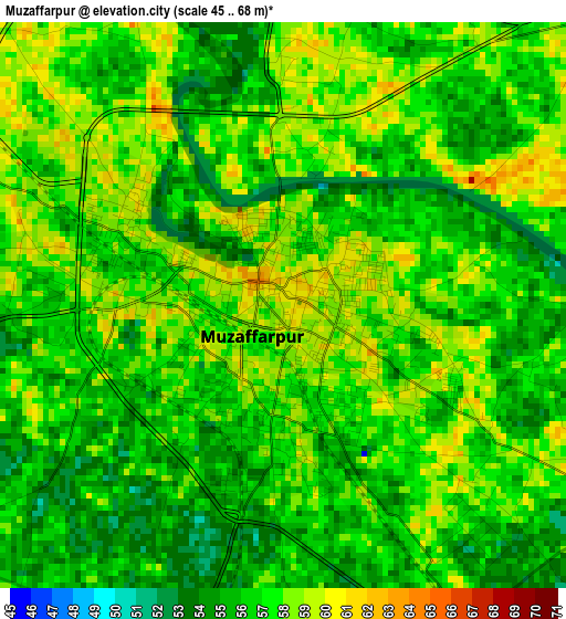
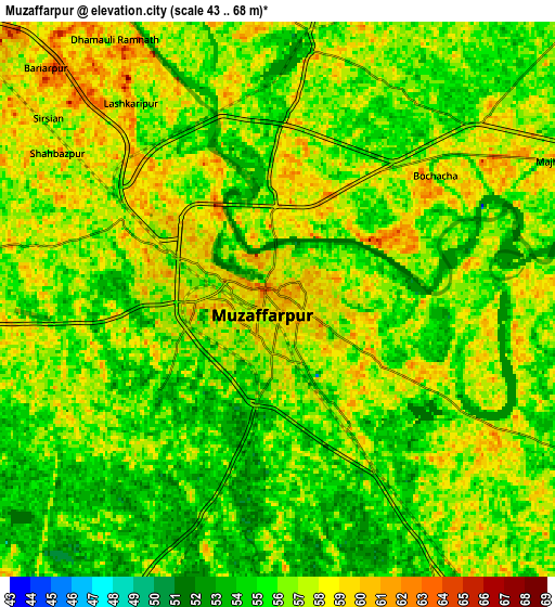
Below is the Elevation map of Muzaffarpur, which displays elevation range with different colors. Scale of the first map is from 45 to 68 m (148 to 223 ft) with average elevation of 56.6 meters (=186 ft) [note 1]
These maps also provides idea of topography and contour of this city, they are displayed at different zoom levels. More info about maps, scale and edge coordinates you can find below images.
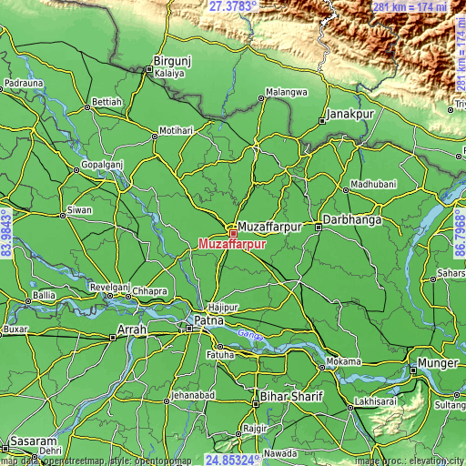
| \ | Map #1 | Map #2 | Topo.Map |
| Scale [m] | 45..68 m | 43..68 m | × |
| Scale [ft] | 148..223 ft | 141..223 ft | × |
| Average | 56.6 m = 186 ft | 56.1 m = 184 ft | × |
| Width | 8.77 km = 5.4 mi | 17.55 km = 10.9 mi | 280.8 km = 174.5 mi |
| Height | 8.77 km = 5.4 mi | 17.55 km = 10.9 mi | 280.8 km = 174.5 mi |
| ↑Max Latitude | 26.16204° | 26.201476° | 27.3783° |
| Latitude at center | 26.12259° | 26.12259° | 26.12259° |
| ↓Min Latitude | 26.083127° | 26.04365° | 24.85324° |
| ← Min Longitude | 85.346605° | 85.302659° | 83.9843° |
| Longitude center | 85.39055° | 85.39055° | 85.39055° |
| →Max Longitude | 85.434495° | 85.478441° | 86.7968° |
Nearby cities:
Cities around Muzaffarpur sort by population:
• Darbhanga elevation 58 m
50.7 km,  86°
86°
• Hājīpur 55 m
51.9 km,  200°
200°
• Samāstipur 52 m
48.5 km,  126°
126°
• Sītāmarhi 70 m
53.3 km,  10°
10°
• Lālganj 59 m
35.6 km,  217°
217°
• Dighwāra 59 m
56.7 km, 222°
• Marhaura 59 m
54.8 km,  252°
252°
• Sheohar 71 m
44.6 km,  347°
347°
• Belsand 67 m
35.7 km,  1°
1°
• Chākia 67 m
47.3 km,  313°
313°
• Dumra 70 m
51.1 km, 14°
• Pupri 63 m
49.7 km,  38°
38°
Multilingual:
 En español:
Muzaffarpur elevación 60 m.
 En France:
Muzaffarpur élévation 60 m.
 Auf Deutsch:
Muzaffarpur höhe über dem Meeresspiegel ist 60 m.

Sources and notes:
- [note 1] Map square and city borders are not equal. Map elevation data is calculated only from area inside that square.
- [src 1] Elevation data from geonames database provided with same terms of usage.
- [src 2] The elevation map of Muzaffarpur is generated using elevation data from NASA's 3 arcsec (90m) resolution SRTM data.
- [src 3] Base (background) map © OpenStreetMap contributors tiles are generated by Geofabrik and OpenTopoMap.
Copyright & License:
This Muzaffarpur Elevation Map is licensed under CC BY-SA. You may reuse any part from this page, if you give a proper credit by linking to this URL:
 More info on terms of use page.