Nīmāj elevation
Nīmāj (Rajasthan, Pāli), India elevation is 316 meters and Nīmāj elevation in feet is 1037 ft above sea level [src 1]. Nīmāj is a populated place (feature code) with elevation that is 23 meters (75 ft) bigger than average city elevation in India.
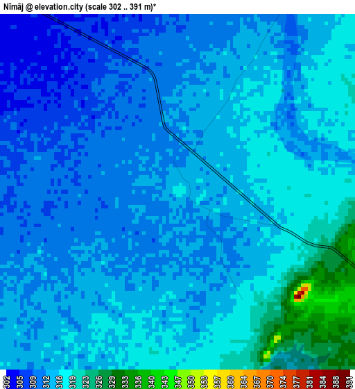
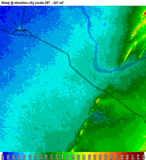
Below is the Elevation map of Nīmāj, which displays elevation range with different colors. Scale of the first map is from 302 to 391 m (991 to 1283 ft) with average elevation of 314.2 meters (=1031 ft) [note 1]
These maps also provides idea of topography and contour of this city, they are displayed at different zoom levels. More info about maps, scale and edge coordinates you can find below images.
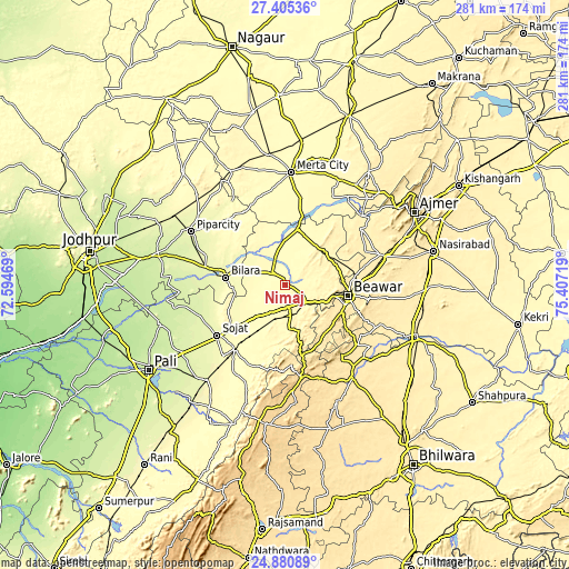
| \ | Map #1 | Map #2 | Topo.Map |
| Scale [m] | 302..391 m | 287..421 m | × |
| Scale [ft] | 991..1283 ft | 942..1381 ft | × |
| Average | 314.2 m = 1031 ft | 317.2 m = 1041 ft | × |
| Width | 8.77 km = 5.4 mi | 17.54 km = 10.9 mi | 280.7 km = 174.4 mi |
| Height | 8.77 km = 5.4 mi | 17.54 km = 10.9 mi | 280.7 km = 174.4 mi |
| ↑Max Latitude | 26.189391° | 26.228818° | 27.40536° |
| Latitude at center | 26.14995° | 26.14995° | 26.14995° |
| ↓Min Latitude | 26.110496° | 26.071029° | 24.88089° |
| ← Min Longitude | 73.956995° | 73.913049° | 72.59469° |
| Longitude center | 74.00094° | 74.00094° | 74.00094° |
| →Max Longitude | 74.044885° | 74.088831° | 75.40719° |
Nearby cities:
Cities around Nīmāj sort by population:
• Ajmer elevation 475 m
71.9 km,  62°
62°
• Beāwar 453 m
32.3 km,  99°
99°
• Merta 324 m
55.5 km,  3°
3°
• Sojat 280 m
41.8 km,  233°
233°
• Bilāra 276 m
29.7 km,  276°
276°
• Pīpār 259 m
52.5 km,  299°
299°
• Gulābpura 400 m
71.3 km,  112°
112°
• Jaitāran 306 m
8.8 km,  313°
313°
• Raipur 336 m
12.2 km,  169°
169°
• Devgarh 638 m
70.1 km,  187°
187°
• Pushkar 495 m
66.7 km, 55°
• Āsind 478 m
56.9 km,  144°
144°
Multilingual:
 En español:
Nīmāj elevación 316 m.
 En France:
Nīmāj élévation 316 m.


Sources and notes:
- [note 1] Map square and city borders are not equal. Map elevation data is calculated only from area inside that square.
- [src 1] Elevation data from geonames database provided with same terms of usage.
- [src 2] The elevation map of Nīmāj is generated using elevation data from NASA's 3 arcsec (90m) resolution SRTM data.
- [src 3] Base (background) map © OpenStreetMap contributors tiles are generated by Geofabrik and OpenTopoMap.
Copyright & License:
This Nīmāj Elevation Map is licensed under CC BY-SA. You may reuse any part from this page, if you give a proper credit by linking to this URL:
 More info on terms of use page.