Omalur elevation
Omalur (Tamil Nadu, Salem), India elevation is 280 meters and Omalur elevation in feet is 919 ft above sea level [src 1]. Omalur is a populated place (feature code) with elevation that is 13 meters (43 ft) smaller than average city elevation in India.
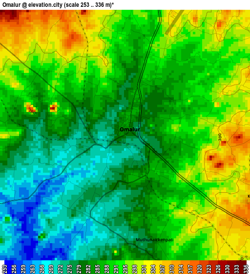
Below is the Elevation map of Omalur, which displays elevation range with different colors. Scale of the first map is from 253 to 336 m (830 to 1102 ft) with average elevation of 287.3 meters (=943 ft) [note 1]
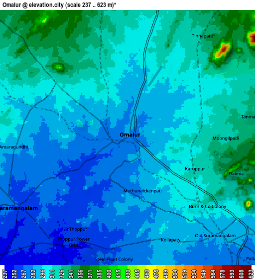
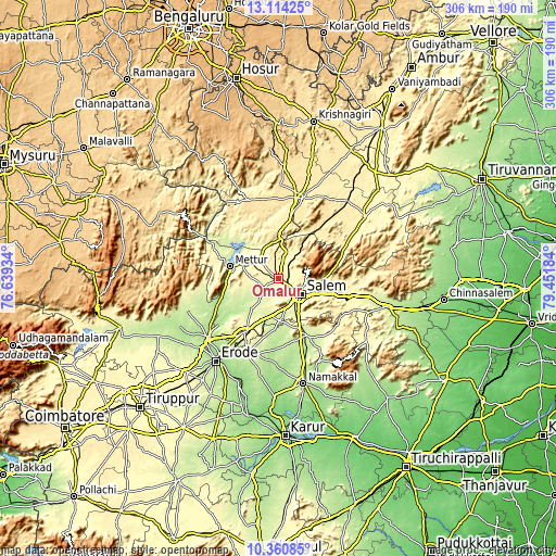
These maps also provides idea of topography and contour of this city, they are displayed at different zoom levels. More info about maps, scale and edge coordinates you can find below images.
| \ | Map #1 | Map #2 | Topo.Map |
| Scale [m] | 253..336 m | 237..623 m | × |
| Scale [ft] | 830..1102 ft | 778..2044 ft | × |
| Average | 287.3 m = 943 ft | 300.3 m = 985 ft | × |
| Width | 9.57 km = 5.9 mi | 19.14 km = 11.9 mi | 306.1 km = 190.2 mi |
| Height | 9.57 km = 5.9 mi | 19.14 km = 11.9 mi | 306.2 km = 190.3 mi |
| ↑Max Latitude | 11.784013° | 11.827028° | 13.11425° |
| Latitude at center | 11.74099° | 11.74099° | 11.74099° |
| ↓Min Latitude | 11.697961° | 11.654925° | 10.36085° |
| ← Min Longitude | 78.001645° | 77.957699° | 76.63934° |
| Longitude center | 78.04559° | 78.04559° | 78.04559° |
| →Max Longitude | 78.089535° | 78.133481° | 79.45184° |
Nearby cities:
Cities around Omalur sort by population:
• Salem elevation 283 m
15.4 km,  129°
129°
• Mettur 205 m
27.2 km,  281°
281°
• Idappadi 209 m
28.3 km,  232°
232°
• Tāramangalam 266 m
9.7 km,  237°
237°
• Mallasamudram 220 m
27.6 km,  183°
183°
• Jalakandapuram 282 m
19.4 km,  255°
255°
• Āttayyāmpatti 235 m
23.2 km, 177°
• Mallāpuram 428 m
34.7 km,  39°
39°
• Ilampillai 275 m
15.5 km,  195°
195°
• Māllūr 279 m
24.2 km,  154°
154°
• Nangavalli 352 m
17 km, 277°
• Konganāpuram 232 m
24.6 km,  219°
219°
Multilingual:
 En español:
Omalur elevación 280 m.
 En France:
Omalur élévation 280 m.


Sources and notes:
- [note 1] Map square and city borders are not equal. Map elevation data is calculated only from area inside that square.
- [src 1] Elevation data from geonames database provided with same terms of usage.
- [src 2] The elevation map of Omalur is generated using elevation data from NASA's 3 arcsec (90m) resolution SRTM data.
- [src 3] Base (background) map © OpenStreetMap contributors tiles are generated by Geofabrik and OpenTopoMap.
Copyright & License:
This Omalur Elevation Map is licensed under CC BY-SA. You may reuse any part from this page, if you give a proper credit by linking to this URL:
 More info on terms of use page.