Pariyāpuram elevation
Pariyāpuram (Kerala, Malappuram), India elevation is 15 meters and Pariyāpuram elevation in feet is 49 ft above sea level [src 1]. Pariyāpuram is a populated place (feature code) with elevation that is 278 meters (912 ft) smaller than average city elevation in India.
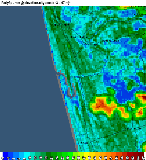
Below is the Elevation map of Pariyāpuram, which displays elevation range with different colors. Scale of the first map is from -3 to 67 m (-10 to 220 ft) with average elevation of 14.8 meters (=49 ft) [note 1]
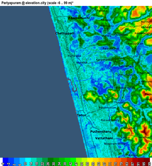
These maps also provides idea of topography and contour of this city, they are displayed at different zoom levels. More info about maps, scale and edge coordinates you can find below images.
| \ | Map #1 | Map #2 | Topo.Map |
| Scale [m] | -3..67 m | -6..99 m | × |
| Scale [ft] | -10..220 ft | -20..325 ft | × |
| Average | 14.8 m = 49 ft | 22 m = 72 ft | × |
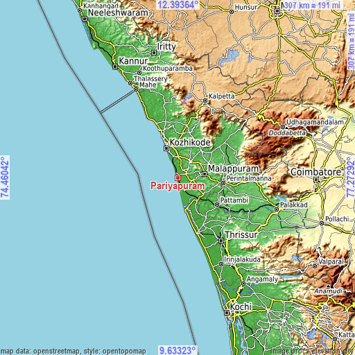
| Width | 9.59 km = 6 mi | 19.18 km = 11.9 mi | 306.9 km = 190.7 mi |
| Height | 9.59 km = 6 mi | 19.18 km = 11.9 mi | 307 km = 190.8 mi |
| ↑Max Latitude | 11.059802° | 11.102928° | 12.39364° |
| Latitude at center | 11.01667° | 11.01667° | 11.01667° |
| ↓Min Latitude | 10.973531° | 10.930386° | 9.63323° |
| ← Min Longitude | 75.822725° | 75.778779° | 74.46042° |
| Longitude center | 75.86667° | 75.86667° | 75.86667° |
| →Max Longitude | 75.910615° | 75.954561° | 77.27292° |
Nearby cities:
Cities around Pariyāpuram sort by population:
• Kozhikode elevation 9 m
27.4 km,  339°
339°
• Ponnāni 7 m
28.5 km,  167°
167°
• Manjeri 46 m
29.9 km,  67°
67°
• Beypore 15 m
18.4 km, 339°
• Kunnamkulam 19 m
46.6 km,  152°
152°
• Malappuram 68 m
23.6 km,  83°
83°
• Tirur 15 m
12.9 km, 152°
• Kunnamangalam 29 m
32 km,  2°
2°
• Ferokh 25 m
18.4 km,  351°
351°
• Cherpulassery 66 m
50.8 km,  107°
107°
• Mavoor 34 m
28.3 km,  11°
11°
• Guruvāyūr 8 m
50.7 km,  157°
157°
Multilingual:
 En español:
Pariyāpuram elevación 15 m.
 En France:
Pariyāpuram élévation 15 m.
 Auf Deutsch:
Pariyāpuram höhe über dem Meeresspiegel ist 15 m.

Sources and notes:
- [note 1] Map square and city borders are not equal. Map elevation data is calculated only from area inside that square.
- [src 1] Elevation data from geonames database provided with same terms of usage.
- [src 2] The elevation map of Pariyāpuram is generated using elevation data from NASA's 3 arcsec (90m) resolution SRTM data.
- [src 3] Base (background) map © OpenStreetMap contributors tiles are generated by Geofabrik and OpenTopoMap.
Copyright & License:
This Pariyāpuram Elevation Map is licensed under CC BY-SA. You may reuse any part from this page, if you give a proper credit by linking to this URL:
 More info on terms of use page.