Pattan elevation
Pattan (Jammu and Kashmir, Bāramūla), India elevation is 1593 meters and Pattan elevation in feet is 5226 ft above sea level [src 1]. Pattan is a populated place (feature code) with elevation that is 1300 meters (4265 ft) bigger than average city elevation in India.
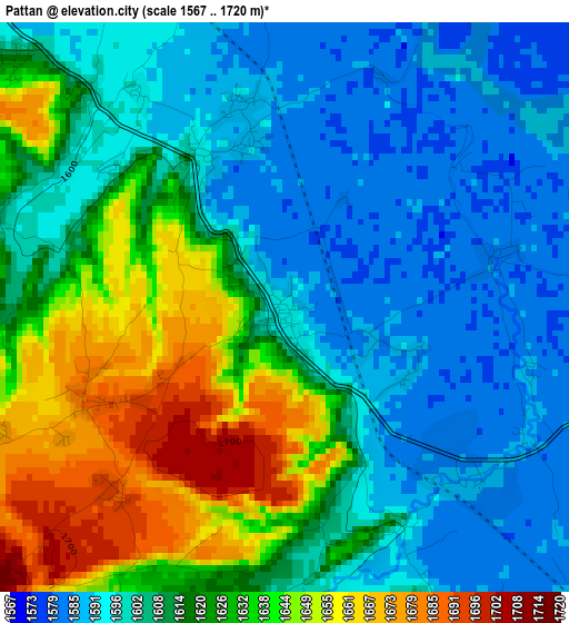
Below is the Elevation map of Pattan, which displays elevation range with different colors. Scale of the first map is from 1567 to 1720 m (5141 to 5643 ft) with average elevation of 1614.6 meters (=5297 ft) [note 1]
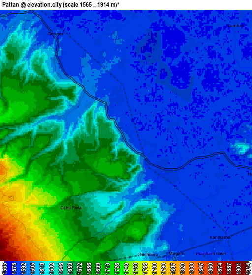
These maps also provides idea of topography and contour of this city, they are displayed at different zoom levels. More info about maps, scale and edge coordinates you can find below images.
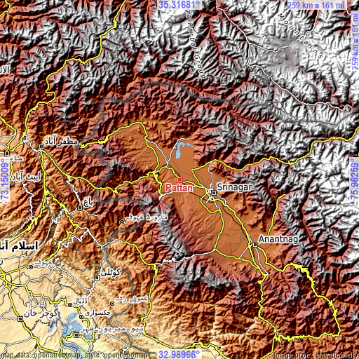
| \ | Map #1 | Map #2 | Topo.Map |
| Scale [m] | 1567..1720 m | 1565..1914 m | × |
| Scale [ft] | 5141..5643 ft | 5135..6280 ft | × |
| Average | 1614.6 m = 5297 ft | 1627.5 m = 5340 ft | × |
| Width | 8.09 km = 5 mi | 16.17 km = 10 mi | 258.8 km = 160.8 mi |
| Height | 8.09 km = 5 mi | 16.17 km = 10 mi | 258.8 km = 160.8 mi |
| ↑Max Latitude | 34.197605° | 34.233945° | 35.31681° |
| Latitude at center | 34.16125° | 34.16125° | 34.16125° |
| ↓Min Latitude | 34.124879° | 34.088493° | 32.98966° |
| ← Min Longitude | 74.512395° | 74.468449° | 73.15009° |
| Longitude center | 74.55634° | 74.55634° | 74.55634° |
| →Max Longitude | 74.600285° | 74.644231° | 75.96259° |
Nearby cities:
Cities around Pattan sort by population:
• Srinagar elevation 1589 m
24.4 km,  110°
110°
• Soyībug 1587 m
16.7 km,  124°
124°
• Bāramūla 1579 m
20.3 km,  285°
285°
• Sopur 1583 m
15.9 km,  331°
331°
• Bandipura 1607 m
29.6 km,  15°
15°
• Pulwama 1648 m
44.9 km,  135°
135°
• Gāndarbal 1593 m
21.3 km,  70°
70°
• Kupwāra 3681 m
30.6 km,  241°
241°
• Sumbal 1585 m
11.4 km,  47°
47°
• Hājan 1582 m
16.3 km, 19°
• Tsrār Sharīf 1953 m
38.3 km,  149°
149°
• Māgām 1591 m
8.2 km,  157°
157°
Multilingual:
 En español:
Pattan elevación 1593 m.
 En France:
Pattan élévation 1593 m.


Sources and notes:
- [note 1] Map square and city borders are not equal. Map elevation data is calculated only from area inside that square.
- [src 1] Elevation data from geonames database provided with same terms of usage.
- [src 2] The elevation map of Pattan is generated using elevation data from NASA's 3 arcsec (90m) resolution SRTM data.
- [src 3] Base (background) map © OpenStreetMap contributors tiles are generated by Geofabrik and OpenTopoMap.
Copyright & License:
This Pattan Elevation Map is licensed under CC BY-SA. You may reuse any part from this page, if you give a proper credit by linking to this URL:
 More info on terms of use page.