Patti elevation
Patti (Punjab, Tarn Taran), India elevation is 219 meters and Patti elevation in feet is 719 ft above sea level [src 1]. Patti is a populated place (feature code) with elevation that is 74 meters (243 ft) smaller than average city elevation in India.
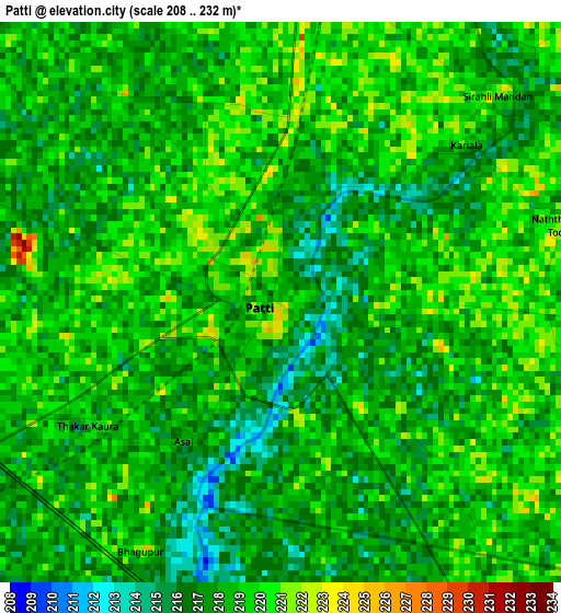
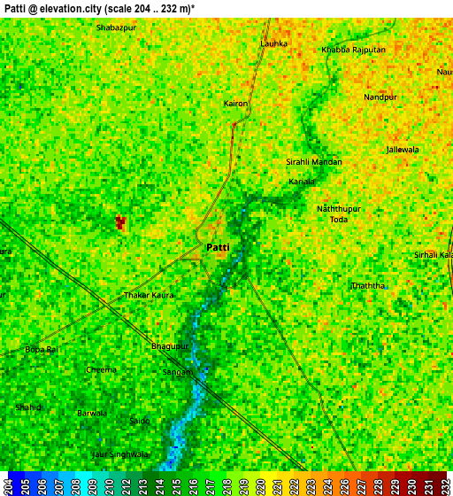
Below is the Elevation map of Patti, which displays elevation range with different colors. Scale of the first map is from 208 to 232 m (682 to 761 ft) with average elevation of 217.9 meters (=715 ft) [note 1]
These maps also provides idea of topography and contour of this city, they are displayed at different zoom levels. More info about maps, scale and edge coordinates you can find below images.
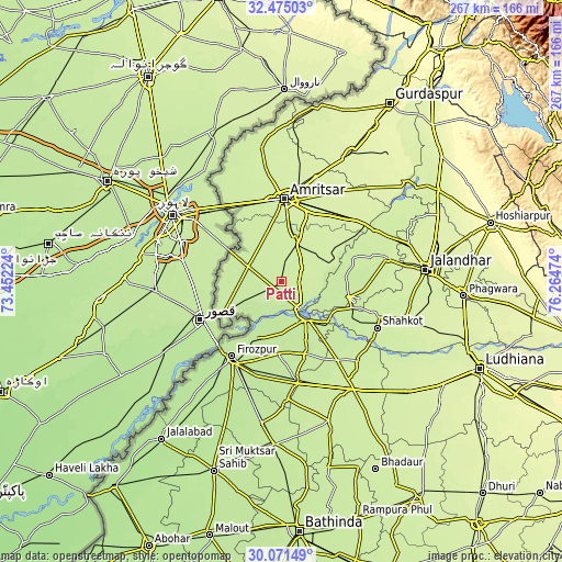
| \ | Map #1 | Map #2 | Topo.Map |
| Scale [m] | 208..232 m | 204..232 m | × |
| Scale [ft] | 682..761 ft | 669..761 ft | × |
| Average | 217.9 m = 715 ft | 218.2 m = 716 ft | × |
| Width | 8.35 km = 5.2 mi | 16.7 km = 10.4 mi | 267.2 km = 166 mi |
| Height | 8.35 km = 5.2 mi | 16.7 km = 10.4 mi | 267.3 km = 166.1 mi |
| ↑Max Latitude | 31.31847° | 31.356004° | 32.47503° |
| Latitude at center | 31.28092° | 31.28092° | 31.28092° |
| ↓Min Latitude | 31.243355° | 31.205776° | 30.07149° |
| ← Min Longitude | 74.814545° | 74.770599° | 73.45224° |
| Longitude center | 74.85849° | 74.85849° | 74.85849° |
| →Max Longitude | 74.902435° | 74.946381° | 76.26474° |
Nearby cities:
Cities around Patti sort by population:
• Amritsar elevation 244 m
38 km,  2°
2°
• Ferozepore 200 m
45.9 km,  210°
210°
• Tarn Tāran 227 m
20.1 km,  19°
19°
• Zira 214 m
37 km,  160°
160°
• Talwandi Bhai 211 m
47.7 km,  171°
171°
• Sultanpur 217 m
32.9 km,  102°
102°
• Shāhkot 227 m
50.6 km,  115°
115°
• Rāja Sānsi 233 m
49.1 km,  353°
353°
• Makhu 213 m
23.7 km,  146°
146°
• Khem Karan 213 m
32.2 km,  241°
241°
• Kot Īsa Khān 218 m
45.7 km,  144°
144°
• Jandiāla Gurū 238 m
35.1 km,  27°
27°
Multilingual:
 En español:
Patti elevación 219 m.
 En France:
Patti élévation 219 m.


Sources and notes:
- [note 1] Map square and city borders are not equal. Map elevation data is calculated only from area inside that square.
- [src 1] Elevation data from geonames database provided with same terms of usage.
- [src 2] The elevation map of Patti is generated using elevation data from NASA's 3 arcsec (90m) resolution SRTM data.
- [src 3] Base (background) map © OpenStreetMap contributors tiles are generated by Geofabrik and OpenTopoMap.
Copyright & License:
This Patti Elevation Map is licensed under CC BY-SA. You may reuse any part from this page, if you give a proper credit by linking to this URL:
 More info on terms of use page.