Pauri elevation
Pauri (Uttarakhand, Garhwāl), India elevation is 1532 meters and Pauri elevation in feet is 5026 ft above sea level [src 1]. Pauri is a populated place (feature code) with elevation that is 1239 meters (4065 ft) bigger than average city elevation in India.
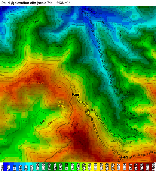
Below is the Elevation map of Pauri, which displays elevation range with different colors. Scale of the first map is from 711 to 2136 m (2333 to 7008 ft) with average elevation of 1374.2 meters (=4509 ft) [note 1]
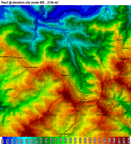
These maps also provides idea of topography and contour of this city, they are displayed at different zoom levels. More info about maps, scale and edge coordinates you can find below images.
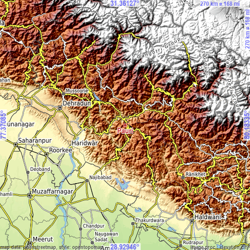
| \ | Map #1 | Map #2 | Topo.Map |
| Scale [m] | 711..2136 m | 509..2136 m | × |
| Scale [ft] | 2333..7008 ft | 1670..7008 ft | × |
| Average | 1374.2 m = 4509 ft | 1341.9 m = 4403 ft | × |
| Width | 8.45 km = 5.3 mi | 16.9 km = 10.5 mi | 270.4 km = 168 mi |
| Height | 8.45 km = 5.3 mi | 16.9 km = 10.5 mi | 270.4 km = 168 mi |
| ↑Max Latitude | 30.190852° | 30.228829° | 31.36127° |
| Latitude at center | 30.15286° | 30.15286° | 30.15286° |
| ↓Min Latitude | 30.114854° | 30.076833° | 28.92946° |
| ← Min Longitude | 78.733155° | 78.689209° | 77.37085° |
| Longitude center | 78.7771° | 78.7771° | 78.7771° |
| →Max Longitude | 78.821045° | 78.864991° | 80.18335° |
Nearby cities:
Cities around Pauri sort by population:
• Haridwar elevation 295 m
63.6 km,  249°
249°
• Rishīkesh 361 m
46.9 km,  263°
263°
• Tehri 656 m
38.9 km,  312°
312°
• Kotdwāra 383 m
51.5 km,  208°
208°
• Srīnagar 554 m
7.8 km,  4°
4°
• Birbhaddar 332 m
48.5 km, 259°
• Lansdowne 1701 m
35.8 km,  195°
195°
• Rāīwāla Bara 320 m
54.8 km, 254°
• Narendranagar 911 m
47.1 km,  271°
271°
• Dugadda 763 m
41.7 km, 202°
• Rudraprayāg 646 m
24.7 km,  53°
53°
• Devaprayāg 615 m
16.8 km, 267°
Multilingual:
 En español:
Pauri elevación 1532 m.
 En France:
Pauri élévation 1532 m.


Sources and notes:
- [note 1] Map square and city borders are not equal. Map elevation data is calculated only from area inside that square.
- [src 1] Elevation data from geonames database provided with same terms of usage.
- [src 2] The elevation map of Pauri is generated using elevation data from NASA's 3 arcsec (90m) resolution SRTM data.
- [src 3] Base (background) map © OpenStreetMap contributors tiles are generated by Geofabrik and OpenTopoMap.
Copyright & License:
This Pauri Elevation Map is licensed under CC BY-SA. You may reuse any part from this page, if you give a proper credit by linking to this URL:
 More info on terms of use page.