Pithorāgarh elevation
Pithorāgarh (Uttarakhand), India elevation is 1586 meters and Pithorāgarh elevation in feet is 5203 ft above sea level [src 1]. Pithorāgarh is a populated place (feature code) with elevation that is 1293 meters (4242 ft) bigger than average city elevation in India.
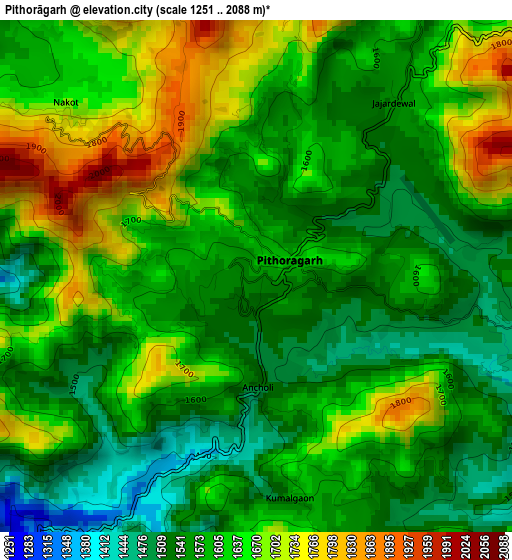
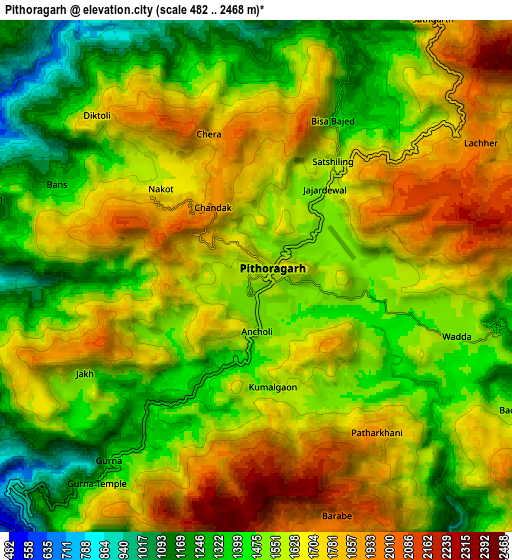
Below is the Elevation map of Pithorāgarh, which displays elevation range with different colors. Scale of the first map is from 1251 to 2088 m (4104 to 6850 ft) with average elevation of 1609.5 meters (=5281 ft) [note 1]
These maps also provides idea of topography and contour of this city, they are displayed at different zoom levels. More info about maps, scale and edge coordinates you can find below images.
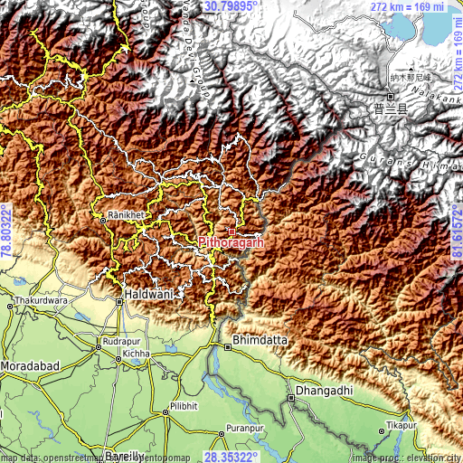
| \ | Map #1 | Map #2 | Topo.Map |
| Scale [m] | 1251..2088 m | 482..2468 m | × |
| Scale [ft] | 4104..6850 ft | 1581..8097 ft | × |
| Average | 1609.5 m = 5281 ft | 1586.8 m = 5206 ft | × |
| Width | 8.5 km = 5.3 mi | 17 km = 10.6 mi | 271.9 km = 169 mi |
| Height | 8.5 km = 5.3 mi | 17 km = 10.6 mi | 271.9 km = 169 mi |
| ↑Max Latitude | 29.621699° | 29.659894° | 30.79895° |
| Latitude at center | 29.58349° | 29.58349° | 29.58349° |
| ↓Min Latitude | 29.545266° | 29.507028° | 28.35322° |
| ← Min Longitude | 80.165525° | 80.121579° | 78.80322° |
| Longitude center | 80.20947° | 80.20947° | 80.20947° |
| →Max Longitude | 80.253415° | 80.297361° | 81.61572° |
Nearby cities:
Cities around Pithorāgarh sort by population:
• Naini Tāl elevation 2077 m
76.7 km,  254°
254°
• Almora 1600 m
53.2 km,  271°
271°
• Rānikhet 1804 m
75.4 km, 274°
• Tanakpur 265 m
57.4 km,  189°
189°
• Khatīma 213 m
77.2 km,  197°
197°
• Bāgeshwar 882 m
50.8 km,  303°
303°
• Dhārchula 1665 m
41.9 km,  45°
45°
• Banbasa 229 m
67.1 km, 191°
• Lohaghāt 1701 m
23.1 km,  210°
210°
• Bhīm Tāl 1343 m
68 km, 246°
• Bhowali 1791 m
71.5 km, 252°
• Champawat 1626 m
30.4 km, 204°
Multilingual:
 En español:
Pithorāgarh elevación 1586 m.
 En France:
Pithorāgarh élévation 1586 m.
 Auf Deutsch:
Pithorāgarh höhe über dem Meeresspiegel ist 1586 m.

Sources and notes:
- [note 1] Map square and city borders are not equal. Map elevation data is calculated only from area inside that square.
- [src 1] Elevation data from geonames database provided with same terms of usage.
- [src 2] The elevation map of Pithorāgarh is generated using elevation data from NASA's 3 arcsec (90m) resolution SRTM data.
- [src 3] Base (background) map © OpenStreetMap contributors tiles are generated by Geofabrik and OpenTopoMap.
Copyright & License:
This Pithorāgarh Elevation Map is licensed under CC BY-SA. You may reuse any part from this page, if you give a proper credit by linking to this URL:
 More info on terms of use page.