Pudukkottai elevation
Pudukkottai (Tamil Nadu), India elevation is 102 meters and Pudukkottai elevation in feet is 335 ft above sea level [src 1]. Pudukkottai is a populated place (feature code) with elevation that is 191 meters (627 ft) smaller than average city elevation in India.
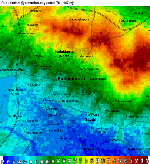
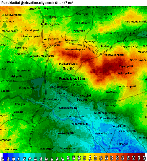
Below is the Elevation map of Pudukkottai, which displays elevation range with different colors. Scale of the first map is from 76 to 147 m (249 to 482 ft) with average elevation of 103.4 meters (=339 ft) [note 1]
These maps also provides idea of topography and contour of this city, they are displayed at different zoom levels. More info about maps, scale and edge coordinates you can find below images.
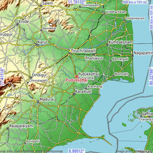
| \ | Map #1 | Map #2 | Topo.Map |
| Scale [m] | 76..147 m | 61..147 m | × |
| Scale [ft] | 249..482 ft | 200..482 ft | × |
| Average | 103.4 m = 339 ft | 100.3 m = 329 ft | × |
| Width | 9.61 km = 6 mi | 19.23 km = 11.9 mi | 307.6 km = 191.1 mi |
| Height | 9.61 km = 6 mi | 19.23 km = 11.9 mi | 307.6 km = 191.1 mi |
| ↑Max Latitude | 10.424503° | 10.46772° | 11.76132° |
| Latitude at center | 10.38128° | 10.38128° | 10.38128° |
| ↓Min Latitude | 10.338051° | 10.294816° | 8.99512° |
| ← Min Longitude | 78.777465° | 78.733519° | 77.41516° |
| Longitude center | 78.82141° | 78.82141° | 78.82141° |
| →Max Longitude | 78.865355° | 78.909301° | 80.22766° |
Nearby cities:
Cities around Pudukkottai sort by population:
• Kāraikkudi elevation 85 m
35.5 km,  189°
189°
• Arantāngi 53 m
29.7 km,  141°
141°
• Iluppūr 146 m
26.2 km,  304°
304°
• Ponnamarāvati 151 m
33.2 km,  250°
250°
• Kottaiyūr 103 m
30.3 km, 185°
• Puliyūr 113 m
28.2 km,  4°
4°
• Ālangudi 81 m
18 km,  97°
97°
• Kīranūr 108 m
21.3 km,  349°
349°
• Pallattūr 105 m
26.2 km,  184°
184°
• Arimalam 80 m
15.6 km,  153°
153°
• Annavāsal 128 m
15.9 km, 303°
• Kanadukattan 107 m
23.7 km, 191°
Multilingual:
 En español:
Pudukkottai elevación 102 m.
 En France:
Pudukkottai élévation 102 m.
 Auf Deutsch:
Pudukkottai höhe über dem Meeresspiegel ist 102 m.

Sources and notes:
- [note 1] Map square and city borders are not equal. Map elevation data is calculated only from area inside that square.
- [src 1] Elevation data from geonames database provided with same terms of usage.
- [src 2] The elevation map of Pudukkottai is generated using elevation data from NASA's 3 arcsec (90m) resolution SRTM data.
- [src 3] Base (background) map © OpenStreetMap contributors tiles are generated by Geofabrik and OpenTopoMap.
Copyright & License:
This Pudukkottai Elevation Map is licensed under CC BY-SA. You may reuse any part from this page, if you give a proper credit by linking to this URL:
 More info on terms of use page.