Puttūr elevation
Puttūr (Andhra Pradesh, Chittoor), India elevation is 152 meters and Puttūr elevation in feet is 499 ft above sea level [src 1]. Puttūr is a populated place (feature code) with elevation that is 141 meters (463 ft) smaller than average city elevation in India.
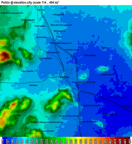
Below is the Elevation map of Puttūr, which displays elevation range with different colors. Scale of the first map is from 114 to 454 m (374 to 1490 ft) with average elevation of 165.8 meters (=544 ft) [note 1]
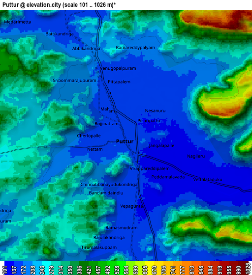
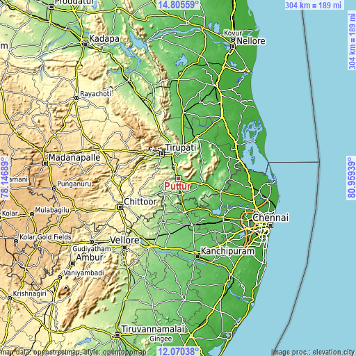
These maps also provides idea of topography and contour of this city, they are displayed at different zoom levels. More info about maps, scale and edge coordinates you can find below images.
| \ | Map #1 | Map #2 | Topo.Map |
| Scale [m] | 114..454 m | 101..1026 m | × |
| Scale [ft] | 374..1490 ft | 331..3366 ft | × |
| Average | 165.8 m = 544 ft | 249.4 m = 818 ft | × |
| Width | 9.5 km = 5.9 mi | 19.01 km = 11.8 mi | 304.1 km = 189 mi |
| Height | 9.5 km = 5.9 mi | 19.01 km = 11.8 mi | 304.2 km = 189 mi |
| ↑Max Latitude | 13.484628° | 13.527358° | 14.80559° |
| Latitude at center | 13.44189° | 13.44189° | 13.44189° |
| ↓Min Latitude | 13.399145° | 13.356392° | 12.07038° |
| ← Min Longitude | 79.509195° | 79.465249° | 78.14689° |
| Longitude center | 79.55314° | 79.55314° | 79.55314° |
| →Max Longitude | 79.597085° | 79.641031° | 80.95939° |
Nearby cities:
Cities around Puttūr sort by population:
• Tirupati elevation 156 m
25.9 km,  326°
326°
• Arakkonam 90 m
41.7 km,  162°
162°
• Thiruthani 85 m
30.4 km,  166°
166°
• Sholinghur 157 m
38.8 km,  201°
201°
• Nagari 116 m
13.8 km, 165°
• Renigunta 112 m
23.7 km,  349°
349°
• Pākāla 367 m
47.4 km,  270°
270°
• Akkarampalle 167 m
27.3 km, 328°
• Tirumala 858 m
34.7 km,  320°
320°
• Nārāyanavanam 128 m
4.3 km,  115°
115°
• Narasingāpuram 206 m
31.5 km,  305°
305°
• Pallipattu 157 m
16.4 km,  225°
225°
Multilingual:
 En español:
Puttūr elevación 152 m.
 En France:
Puttūr élévation 152 m.


Sources and notes:
- [note 1] Map square and city borders are not equal. Map elevation data is calculated only from area inside that square.
- [src 1] Elevation data from geonames database provided with same terms of usage.
- [src 2] The elevation map of Puttūr is generated using elevation data from NASA's 3 arcsec (90m) resolution SRTM data.
- [src 3] Base (background) map © OpenStreetMap contributors tiles are generated by Geofabrik and OpenTopoMap.
Copyright & License:
This Puttūr Elevation Map is licensed under CC BY-SA. You may reuse any part from this page, if you give a proper credit by linking to this URL:
 More info on terms of use page.