Rāghogarh elevation
Rāghogarh (Madhya Pradesh, Guna), India elevation is 444 meters and Rāghogarh elevation in feet is 1457 ft above sea level [src 1]. Rāghogarh is a populated place (feature code) with elevation that is 151 meters (495 ft) bigger than average city elevation in India.
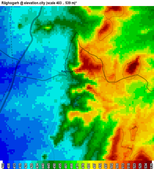
Below is the Elevation map of Rāghogarh, which displays elevation range with different colors. Scale of the first map is from 403 to 539 m (1322 to 1768 ft) with average elevation of 453.7 meters (=1489 ft) [note 1]
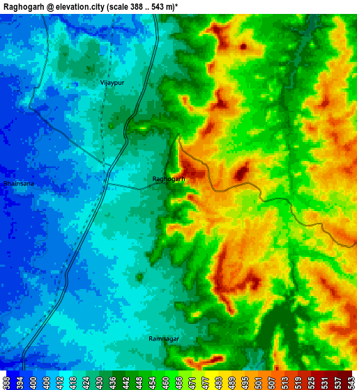
These maps also provides idea of topography and contour of this city, they are displayed at different zoom levels. More info about maps, scale and edge coordinates you can find below images.
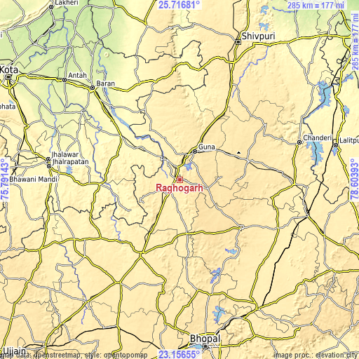
| \ | Map #1 | Map #2 | Topo.Map |
| Scale [m] | 403..539 m | 388..543 m | × |
| Scale [ft] | 1322..1768 ft | 1273..1781 ft | × |
| Average | 453.7 m = 1489 ft | 442.4 m = 1451 ft | × |
| Width | 8.9 km = 5.5 mi | 17.79 km = 11.1 mi | 284.7 km = 176.9 mi |
| Height | 8.9 km = 5.5 mi | 17.79 km = 11.1 mi | 284.7 km = 176.9 mi |
| ↑Max Latitude | 24.48318° | 24.523168° | 25.71681° |
| Latitude at center | 24.44318° | 24.44318° | 24.44318° |
| ↓Min Latitude | 24.403167° | 24.363141° | 23.15655° |
| ← Min Longitude | 77.153735° | 77.109789° | 75.79143° |
| Longitude center | 77.19768° | 77.19768° | 77.19768° |
| →Max Longitude | 77.241625° | 77.285571° | 78.60393° |
Nearby cities:
Cities around Rāghogarh sort by population:
• Guna elevation 474 m
25.4 km,  26°
26°
• Ashoknagar 504 m
56 km,  74°
74°
• Sironj 472 m
62.7 km,  127°
127°
• Biaora 433 m
65 km,  206°
206°
• Rājgarh 359 m
67.6 km,  224°
224°
• Chhabra 336 m
43.4 km,  304°
304°
• Āron 524 m
23.3 km,  107°
107°
• Aklera 321 m
63.9 km,  266°
266°
• Kumbhrāj 414 m
17 km,  242°
242°
• Leteri 534 m
47.7 km,  153°
153°
• Manohar Thāna 337 m
46 km, 240°
• Garha Brahman 470 m
65.9 km,  165°
165°
Multilingual:
 En español:
Rāghogarh elevación 444 m.
 En France:
Rāghogarh élévation 444 m.
 Auf Deutsch:
Rāghogarh höhe über dem Meeresspiegel ist 444 m.

Sources and notes:
- [note 1] Map square and city borders are not equal. Map elevation data is calculated only from area inside that square.
- [src 1] Elevation data from geonames database provided with same terms of usage.
- [src 2] The elevation map of Rāghogarh is generated using elevation data from NASA's 3 arcsec (90m) resolution SRTM data.
- [src 3] Base (background) map © OpenStreetMap contributors tiles are generated by Geofabrik and OpenTopoMap.
Copyright & License:
This Rāghogarh Elevation Map is licensed under CC BY-SA. You may reuse any part from this page, if you give a proper credit by linking to this URL:
 More info on terms of use page.