Rajaori elevation
Rajaori (Jammu and Kashmir, Rājauri), India elevation is 924 meters and Rajaori elevation in feet is 3031 ft above sea level [src 1]. Rajaori is a populated place (feature code) with elevation that is 631 meters (2070 ft) bigger than average city elevation in India.
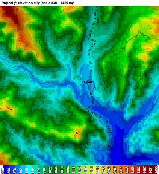
Below is the Elevation map of Rajaori, which displays elevation range with different colors. Scale of the first map is from 830 to 1455 m (2723 to 4774 ft) with average elevation of 1022.7 meters (=3355 ft) [note 1]
These maps also provides idea of topography and contour of this city, they are displayed at different zoom levels. More info about maps, scale and edge coordinates you can find below images.
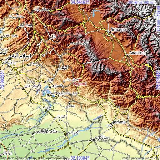
| \ | Map #1 | Map #2 | Topo.Map |
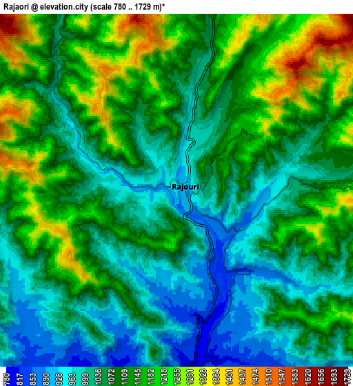
| Scale [m] | 830..1455 m | 780..1729 m | × |
| Scale [ft] | 2723..4774 ft | 2559..5673 ft | × |
| Average | 1022.7 m = 3355 ft | 1089.8 m = 3575 ft | × |
| Width | 8.16 km = 5.1 mi | 16.32 km = 10.1 mi | 261.1 km = 162.2 mi |
| Height | 8.16 km = 5.1 mi | 16.32 km = 10.1 mi | 261.1 km = 162.2 mi |
| ↑Max Latitude | 33.41195° | 33.448625° | 34.54163° |
| Latitude at center | 33.37526° | 33.37526° | 33.37526° |
| ↓Min Latitude | 33.338554° | 33.301833° | 32.19304° |
| ← Min Longitude | 74.265255° | 74.221309° | 72.90295° |
| Longitude center | 74.3092° | 74.3092° | 74.3092° |
| →Max Longitude | 74.353145° | 74.397091° | 75.71545° |
Nearby cities:
Cities around Rajaori sort by population:
• Pūnch elevation 999 m
48.3 km,  335°
335°
• Kulgam 1742 m
72.3 km,  65°
65°
• Nawānshahr 247 m
70.8 km,  163°
163°
• Kupwāra 3681 m
73 km,  356°
356°
• Shupīyan 2055 m
61.7 km,  51°
51°
• Akhnūr 312 m
69 km,  145°
145°
• Katra 868 m
72 km,  126°
126°
• Riāsi 521 m
58.6 km,  123°
123°
• Tsrār Sharīf 1953 m
68.7 km,  37°
37°
• Rāmgarh 1373 m
8.5 km,  291°
291°
• Jauriān 281 m
65.3 km, 157°
• Thanna Mandi 1572 m
19.7 km,  19°
19°
Multilingual:
 En español:
Rajaori elevación 924 m.
 En France:
Rajaori élévation 924 m.


Sources and notes:
- [note 1] Map square and city borders are not equal. Map elevation data is calculated only from area inside that square.
- [src 1] Elevation data from geonames database provided with same terms of usage.
- [src 2] The elevation map of Rajaori is generated using elevation data from NASA's 3 arcsec (90m) resolution SRTM data.
- [src 3] Base (background) map © OpenStreetMap contributors tiles are generated by Geofabrik and OpenTopoMap.
Copyright & License:
This Rajaori Elevation Map is licensed under CC BY-SA. You may reuse any part from this page, if you give a proper credit by linking to this URL:
 More info on terms of use page.