Renukūt elevation
Renukūt (Uttar Pradesh, Sonbhadra), India elevation is 297 meters and Renukūt elevation in feet is 974 ft above sea level [src 1]. Renukūt is a populated place (feature code) with elevation that is 4 meters (13 ft) bigger than average city elevation in India.
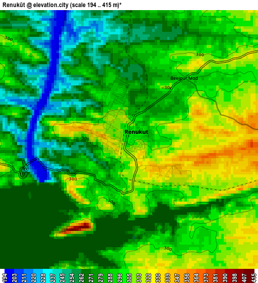
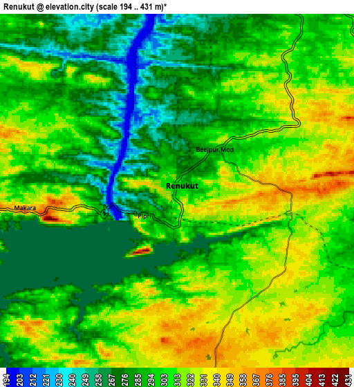
Below is the Elevation map of Renukūt, which displays elevation range with different colors. Scale of the first map is from 194 to 415 m (636 to 1362 ft) with average elevation of 285.6 meters (=937 ft) [note 1]
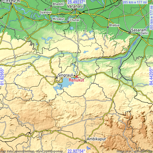
These maps also provides idea of topography and contour of this city, they are displayed at different zoom levels. More info about maps, scale and edge coordinates you can find below images.
| \ | Map #1 | Map #2 | Topo.Map |
| Scale [m] | 194..415 m | 194..431 m | × |
| Scale [ft] | 636..1362 ft | 636..1414 ft | × |
| Average | 285.6 m = 937 ft | 300.2 m = 985 ft | × |
| Width | 8.91 km = 5.5 mi | 17.83 km = 11.1 mi | 285.2 km = 177.2 mi |
| Height | 8.91 km = 5.5 mi | 17.83 km = 11.1 mi | 285.2 km = 177.2 mi |
| ↑Max Latitude | 24.256482° | 24.296541° | 25.49237° |
| Latitude at center | 24.21641° | 24.21641° | 24.21641° |
| ↓Min Latitude | 24.176325° | 24.136228° | 22.92754° |
| ← Min Longitude | 82.991855° | 82.947909° | 81.62955° |
| Longitude center | 83.0358° | 83.0358° | 83.0358° |
| →Max Longitude | 83.079745° | 83.123691° | 84.44205° |
Nearby cities:
Cities around Renukūt sort by population:
• Singrauli elevation 383 m
36.6 km,  267°
267°
• Obra 205 m
23 km,  347°
347°
• Garhwa 203 m
78.5 km,  94°
94°
• Robertsganj 321 m
52.6 km,  3°
3°
• Ahraura 106 m
88.9 km,  359°
359°
• Chakia 96 m
94.4 km,  11°
11°
• Kota 189 m
27.3 km,  20°
20°
• Chopan 198 m
33.7 km, 357°
• Dūdhi 250 m
20.8 km, 90°
• Rāmānuj Ganj 436 m
81.4 km,  124°
124°
• Ghorāwal 300 m
65.2 km,  336°
336°
• Balrampur 532 m
89.1 km,  138°
138°
Multilingual:
 En español:
Renukūt elevación 297 m.
 En France:
Renukūt élévation 297 m.


Sources and notes:
- [note 1] Map square and city borders are not equal. Map elevation data is calculated only from area inside that square.
- [src 1] Elevation data from geonames database provided with same terms of usage.
- [src 2] The elevation map of Renukūt is generated using elevation data from NASA's 3 arcsec (90m) resolution SRTM data.
- [src 3] Base (background) map © OpenStreetMap contributors tiles are generated by Geofabrik and OpenTopoMap.
Copyright & License:
This Renukūt Elevation Map is licensed under CC BY-SA. You may reuse any part from this page, if you give a proper credit by linking to this URL:
 More info on terms of use page.