Shāhpur elevation
Shāhpur (Bihar, Bhojpur), India elevation is 66 meters and Shāhpur elevation in feet is 217 ft above sea level [src 1]. Shāhpur is a populated place (feature code) with elevation that is 227 meters (745 ft) smaller than average city elevation in India.
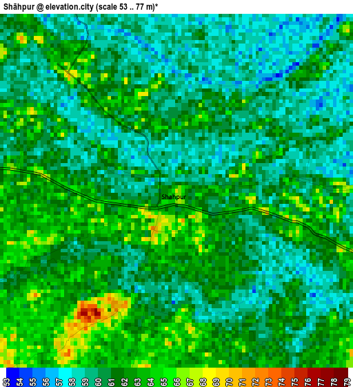
Below is the Elevation map of Shāhpur, which displays elevation range with different colors. Scale of the first map is from 53 to 77 m (174 to 253 ft) with average elevation of 60.9 meters (=200 ft) [note 1]
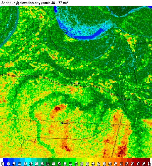
These maps also provides idea of topography and contour of this city, they are displayed at different zoom levels. More info about maps, scale and edge coordinates you can find below images.
| \ | Map #1 | Map #2 | Topo.Map |
| Scale [m] | 53..77 m | 48..77 m | × |
| Scale [ft] | 174..253 ft | 157..253 ft | × |
| Average | 60.9 m = 200 ft | 61 m = 200 ft | × |
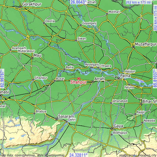
| Width | 8.81 km = 5.5 mi | 17.63 km = 11 mi | 282 km = 175.2 mi |
| Height | 8.81 km = 5.5 mi | 17.63 km = 11 mi | 282 km = 175.2 mi |
| ↑Max Latitude | 25.642554° | 25.682164° | 26.8643° |
| Latitude at center | 25.60293° | 25.60293° | 25.60293° |
| ↓Min Latitude | 25.563293° | 25.523643° | 24.32811° |
| ← Min Longitude | 84.360175° | 84.316229° | 82.99787° |
| Longitude center | 84.40412° | 84.40412° | 84.40412° |
| →Max Longitude | 84.448065° | 84.492011° | 85.81037° |
Nearby cities:
Cities around Shāhpur sort by population:
• Arrah elevation 64 m
26.5 km,  101°
101°
• Chāpra 61 m
39.6 km,  60°
60°
• Buxar 67 m
42.6 km,  265°
265°
• Dumraon 76 m
25.9 km,  257°
257°
• Bikramganj 93 m
46.1 km,  198°
198°
• Revelganj 60 m
31.2 km,  48°
48°
• Jagdīspur 76 m
15.1 km,  174°
174°
• Piro 84 m
30.1 km,  179°
179°
• Koelwār 64 m
39.5 km,  93°
93°
• Reoti 64 m
27.7 km,  354°
354°
• Bānsdīh 68 m
36.4 km,  329°
329°
• Koāth 88 m
34 km,  205°
205°
Multilingual:
 En español:
Shāhpur elevación 66 m.
 En France:
Shāhpur élévation 66 m.


Sources and notes:
- [note 1] Map square and city borders are not equal. Map elevation data is calculated only from area inside that square.
- [src 1] Elevation data from geonames database provided with same terms of usage.
- [src 2] The elevation map of Shāhpur is generated using elevation data from NASA's 3 arcsec (90m) resolution SRTM data.
- [src 3] Base (background) map © OpenStreetMap contributors tiles are generated by Geofabrik and OpenTopoMap.
Copyright & License:
This Shāhpur Elevation Map is licensed under CC BY-SA. You may reuse any part from this page, if you give a proper credit by linking to this URL:
 More info on terms of use page.