Shājāpur elevation
Shājāpur (Madhya Pradesh), India elevation is 445 meters and Shājāpur elevation in feet is 1460 ft above sea level [src 1]. Shājāpur is a populated place (feature code) with elevation that is 152 meters (499 ft) bigger than average city elevation in India.
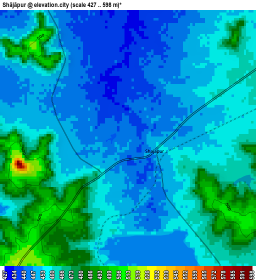
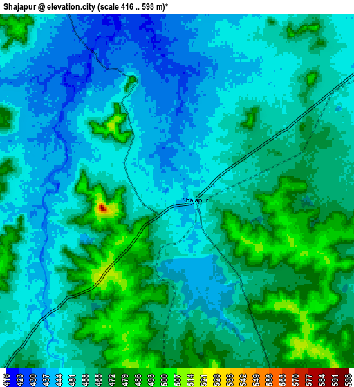
Below is the Elevation map of Shājāpur, which displays elevation range with different colors. Scale of the first map is from 427 to 598 m (1401 to 1962 ft) with average elevation of 459.1 meters (=1506 ft) [note 1]
These maps also provides idea of topography and contour of this city, they are displayed at different zoom levels. More info about maps, scale and edge coordinates you can find below images.
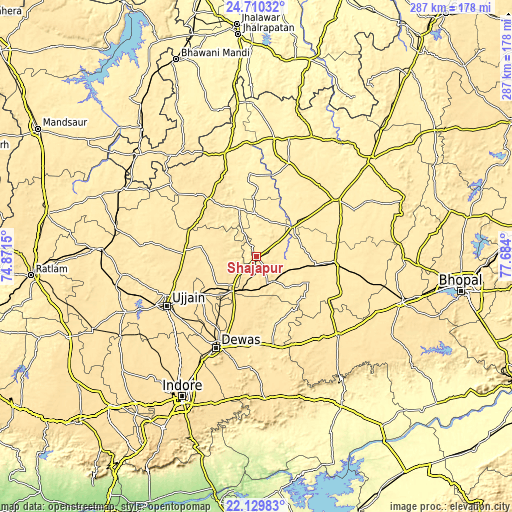
| \ | Map #1 | Map #2 | Topo.Map |
| Scale [m] | 427..598 m | 416..598 m | × |
| Scale [ft] | 1401..1962 ft | 1365..1962 ft | × |
| Average | 459.1 m = 1506 ft | 458.2 m = 1503 ft | × |
| Width | 8.97 km = 5.6 mi | 17.93 km = 11.1 mi | 286.9 km = 178.3 mi |
| Height | 8.97 km = 5.6 mi | 17.93 km = 11.1 mi | 286.9 km = 178.3 mi |
| ↑Max Latitude | 23.466687° | 23.506991° | 24.71032° |
| Latitude at center | 23.42637° | 23.42637° | 23.42637° |
| ↓Min Latitude | 23.386041° | 23.345699° | 22.12983° |
| ← Min Longitude | 76.233805° | 76.189859° | 74.8715° |
| Longitude center | 76.27775° | 76.27775° | 76.27775° |
| →Max Longitude | 76.321695° | 76.365641° | 77.684° |
Nearby cities:
Cities around Shājāpur sort by population:
• Ujjain elevation 494 m
57.9 km,  242°
242°
• Dewas 544 m
56 km,  203°
203°
• Shujālpur 452 m
44.1 km,  92°
92°
• Sārangpur 431 m
25.3 km,  51°
51°
• Agar 519 m
41.5 km,  319°
319°
• Tarāna 501 m
26.1 km,  246°
246°
• Maksi 503 m
22.9 km,  216°
216°
• Akodia 463 m
33.2 km,  98°
98°
• Khujner 442 m
52.9 km,  40°
40°
• Talen 436 m
48.6 km,  70°
70°
• Iklehra 459 m
33.2 km,  159°
159°
• Iāwar 496 m
51.7 km,  153°
153°
Multilingual:
 En español:
Shājāpur elevación 445 m.
 En France:
Shājāpur élévation 445 m.
 Auf Deutsch:
Shājāpur höhe über dem Meeresspiegel ist 445 m.

Sources and notes:
- [note 1] Map square and city borders are not equal. Map elevation data is calculated only from area inside that square.
- [src 1] Elevation data from geonames database provided with same terms of usage.
- [src 2] The elevation map of Shājāpur is generated using elevation data from NASA's 3 arcsec (90m) resolution SRTM data.
- [src 3] Base (background) map © OpenStreetMap contributors tiles are generated by Geofabrik and OpenTopoMap.
Copyright & License:
This Shājāpur Elevation Map is licensed under CC BY-SA. You may reuse any part from this page, if you give a proper credit by linking to this URL:
 More info on terms of use page.