Shamsābād elevation
Shamsābād (Uttar Pradesh, Farrukhābād), India elevation is 158 meters and Shamsābād elevation in feet is 518 ft above sea level [src 1]. Shamsābād is a populated place (feature code) with elevation that is 135 meters (443 ft) smaller than average city elevation in India.
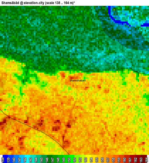
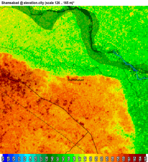
Below is the Elevation map of Shamsābād, which displays elevation range with different colors. Scale of the first map is from 138 to 164 m (453 to 538 ft) with average elevation of 150.4 meters (=493 ft) [note 1]
These maps also provides idea of topography and contour of this city, they are displayed at different zoom levels. More info about maps, scale and edge coordinates you can find below images.
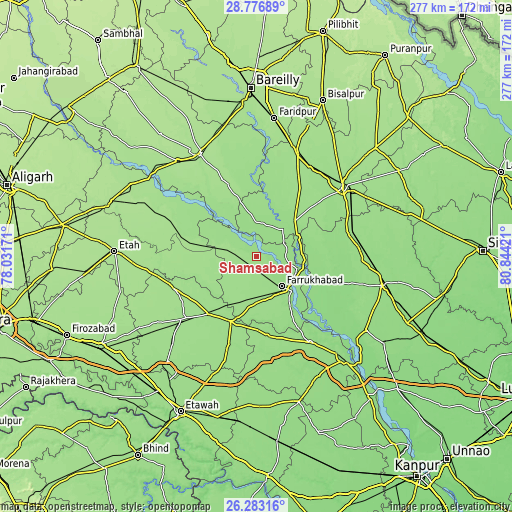
| \ | Map #1 | Map #2 | Topo.Map |
| Scale [m] | 138..164 m | 126..165 m | × |
| Scale [ft] | 453..538 ft | 413..541 ft | × |
| Average | 150.4 m = 493 ft | 149.7 m = 491 ft | × |
| Width | 8.67 km = 5.4 mi | 17.33 km = 10.8 mi | 277.3 km = 172.3 mi |
| Height | 8.67 km = 5.4 mi | 17.33 km = 10.8 mi | 277.3 km = 172.3 mi |
| ↑Max Latitude | 27.57606° | 27.615006° | 28.77689° |
| Latitude at center | 27.5371° | 27.5371° | 27.5371° |
| ↓Min Latitude | 27.498126° | 27.459139° | 26.28316° |
| ← Min Longitude | 79.394015° | 79.350069° | 78.03171° |
| Longitude center | 79.43796° | 79.43796° | 79.43796° |
| →Max Longitude | 79.481905° | 79.525851° | 80.84421° |
Nearby cities:
Cities around Shamsābād sort by population:
• Farrukhābād elevation 156 m
21.4 km,  139°
139°
• Jalālābād 154 m
30 km,  45°
45°
• Kaimganj 161 m
10.3 km,  280°
280°
• Bhongaon 163 m
40.3 km,  218°
218°
• Alīganj 163 m
26.7 km,  259°
259°
• Bewar 158 m
38 km,  201°
201°
• Muhammadābād 153 m
25.4 km,  181°
181°
• Kamalganj 152 m
36.1 km,  148°
148°
• Usehat 162 m
35.1 km,  325°
325°
• Fatehgarh 153 m
27.1 km, 135°
• Allāhganj 144 m
24.6 km,  87°
87°
• Kampil 161 m
18 km,  297°
297°
Multilingual:
 En español:
Shamsābād elevación 158 m.
 En France:
Shamsābād élévation 158 m.
 Auf Deutsch:
Shamsābād höhe über dem Meeresspiegel ist 158 m.

Sources and notes:
- [note 1] Map square and city borders are not equal. Map elevation data is calculated only from area inside that square.
- [src 1] Elevation data from geonames database provided with same terms of usage.
- [src 2] The elevation map of Shamsābād is generated using elevation data from NASA's 3 arcsec (90m) resolution SRTM data.
- [src 3] Base (background) map © OpenStreetMap contributors tiles are generated by Geofabrik and OpenTopoMap.
Copyright & License:
This Shamsābād Elevation Map is licensed under CC BY-SA. You may reuse any part from this page, if you give a proper credit by linking to this URL:
 More info on terms of use page.