Shrīgonda elevation
Shrīgonda (Maharashtra, Ahmadnagar), India elevation is 558 meters and Shrīgonda elevation in feet is 1831 ft above sea level [src 1]. Shrīgonda is a populated place (feature code) with elevation that is 265 meters (869 ft) bigger than average city elevation in India.
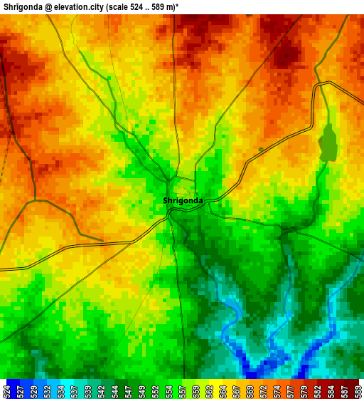
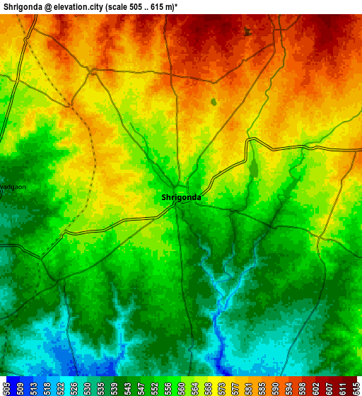
Below is the Elevation map of Shrīgonda, which displays elevation range with different colors. Scale of the first map is from 524 to 589 m (1719 to 1932 ft) with average elevation of 560.2 meters (=1838 ft) [note 1]
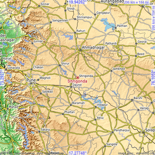
These maps also provides idea of topography and contour of this city, they are displayed at different zoom levels. More info about maps, scale and edge coordinates you can find below images.
| \ | Map #1 | Map #2 | Topo.Map |
| Scale [m] | 524..589 m | 505..615 m | × |
| Scale [ft] | 1719..1932 ft | 1657..2018 ft | × |
| Average | 560.2 m = 1838 ft | 560.5 m = 1839 ft | × |
| Width | 9.26 km = 5.8 mi | 18.52 km = 11.5 mi | 296.3 km = 184.1 mi |
| Height | 9.26 km = 5.8 mi | 18.52 km = 11.5 mi | 296.4 km = 184.2 mi |
| ↑Max Latitude | 18.656911° | 18.698542° | 19.94262° |
| Latitude at center | 18.61527° | 18.61527° | 18.61527° |
| ↓Min Latitude | 18.573619° | 18.531957° | 17.27748° |
| ← Min Longitude | 74.655005° | 74.611059° | 73.2927° |
| Longitude center | 74.69895° | 74.69895° | 74.69895° |
| →Max Longitude | 74.742895° | 74.786841° | 76.1052° |
Nearby cities:
Cities around Shrīgonda sort by population:
• Ahmadnagar elevation 661 m
53.5 km,  4°
4°
• Bārāmati 552 m
53.1 km,  193°
193°
• Phaltan 560 m
74.9 km,  202°
202°
• Daund 517 m
20.6 km,  216°
216°
• Sirūr 568 m
41.5 km,  304°
304°
• Sāsvad 771 m
76.6 km,  246°
246°
• Ārangaon 672 m
45.8 km, 2°
• Koregaon 552 m
67.5 km,  272°
272°
• Karmāla 559 m
57.1 km,  113°
113°
• Kalas 560 m
50.2 km,  168°
168°
• Jejūri 729 m
68.2 km,  236°
236°
• Bhigvan 501 m
35.7 km, 168°
Multilingual:
 En español:
Shrīgonda elevación 558 m.
 En France:
Shrīgonda élévation 558 m.
 Auf Deutsch:
Shrīgonda höhe über dem Meeresspiegel ist 558 m.

Sources and notes:
- [note 1] Map square and city borders are not equal. Map elevation data is calculated only from area inside that square.
- [src 1] Elevation data from geonames database provided with same terms of usage.
- [src 2] The elevation map of Shrīgonda is generated using elevation data from NASA's 3 arcsec (90m) resolution SRTM data.
- [src 3] Base (background) map © OpenStreetMap contributors tiles are generated by Geofabrik and OpenTopoMap.
Copyright & License:
This Shrīgonda Elevation Map is licensed under CC BY-SA. You may reuse any part from this page, if you give a proper credit by linking to this URL:
 More info on terms of use page.