Singtam elevation
Singtam (Sikkim, East District), India elevation is 477 meters and Singtam elevation in feet is 1565 ft above sea level [src 1]. Singtam is a populated place (feature code) with elevation that is 184 meters (604 ft) bigger than average city elevation in India.
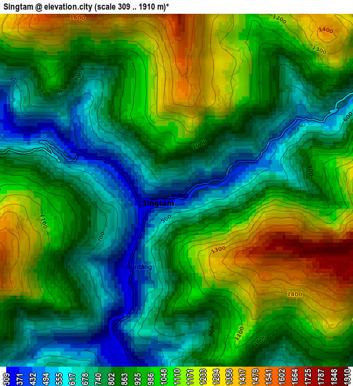
Below is the Elevation map of Singtam, which displays elevation range with different colors. Scale of the first map is from 309 to 1910 m (1014 to 6266 ft) with average elevation of 921.8 meters (=3024 ft) [note 1]
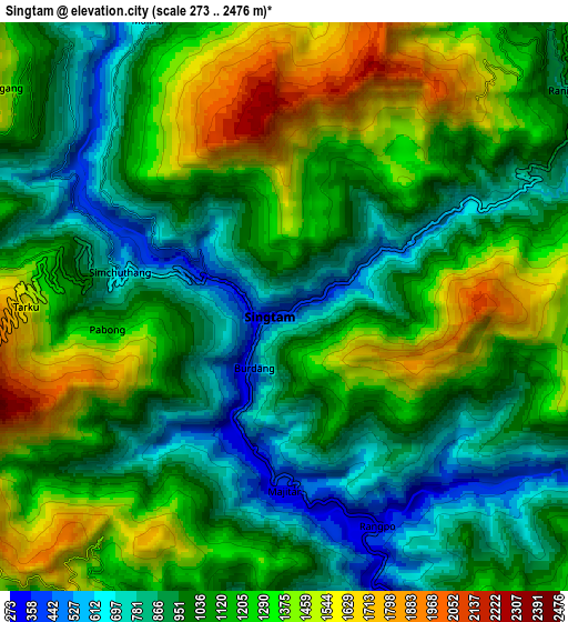
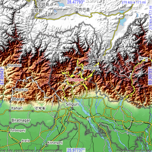
These maps also provides idea of topography and contour of this city, they are displayed at different zoom levels. More info about maps, scale and edge coordinates you can find below images.
| \ | Map #1 | Map #2 | Topo.Map |
| Scale [m] | 309..1910 m | 273..2476 m | × |
| Scale [ft] | 1014..6266 ft | 896..8123 ft | × |
| Average | 921.8 m = 3024 ft | 1117.2 m = 3665 ft | × |
| Width | 8.69 km = 5.4 mi | 17.38 km = 10.8 mi | 278 km = 172.7 mi |
| Height | 8.69 km = 5.4 mi | 17.38 km = 10.8 mi | 278 km = 172.7 mi |
| ↑Max Latitude | 27.273737° | 27.31279° | 28.47793° |
| Latitude at center | 27.23467° | 27.23467° | 27.23467° |
| ↓Min Latitude | 27.19559° | 27.156496° | 25.97737° |
| ← Min Longitude | 88.457735° | 88.413789° | 87.09543° |
| Longitude center | 88.50168° | 88.50168° | 88.50168° |
| →Max Longitude | 88.545625° | 88.589571° | 89.90793° |
Nearby cities:
Cities around Singtam sort by population:
• Dārjiling elevation 2127 m
32.3 km,  226°
226°
• Kārsiyāng 1501 m
45 km,  209°
209°
• Kālimpong 1141 m
18.4 km,  188°
188°
• Gangtok 1654 m
14.9 km,  47°
47°
• Odlābāri 147 m
46.1 km,  164°
164°
• Rangpo 307 m
7.1 km,  153°
153°
• Gyalshing 1294 m
24.9 km,  284°
284°
• Jorethang 290 m
22.6 km, 231°
• Mangan 953 m
30.6 km,  3°
3°
• Namchi 1427 m
15.7 km,  240°
240°
• Naya Bāzār 927 m
28.4 km,  245°
245°
• Kalimpong, Крукети 1340 m
20.2 km, 191°
Multilingual:
 En español:
Singtam elevación 477 m.
 En France:
Singtam élévation 477 m.


Sources and notes:
- [note 1] Map square and city borders are not equal. Map elevation data is calculated only from area inside that square.
- [src 1] Elevation data from geonames database provided with same terms of usage.
- [src 2] The elevation map of Singtam is generated using elevation data from NASA's 3 arcsec (90m) resolution SRTM data.
- [src 3] Base (background) map © OpenStreetMap contributors tiles are generated by Geofabrik and OpenTopoMap.
Copyright & License:
This Singtam Elevation Map is licensed under CC BY-SA. You may reuse any part from this page, if you give a proper credit by linking to this URL:
 More info on terms of use page.