Sirohi elevation
Sirohi (Rajasthan), India elevation is 294 meters and Sirohi elevation in feet is 965 ft above sea level [src 1]. Sirohi is a populated place (feature code) with elevation that is 1 meters (3 ft) bigger than average city elevation in India.
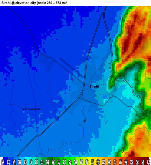
Below is the Elevation map of Sirohi, which displays elevation range with different colors. Scale of the first map is from 260 to 673 m (853 to 2208 ft) with average elevation of 329.9 meters (=1082 ft) [note 1]
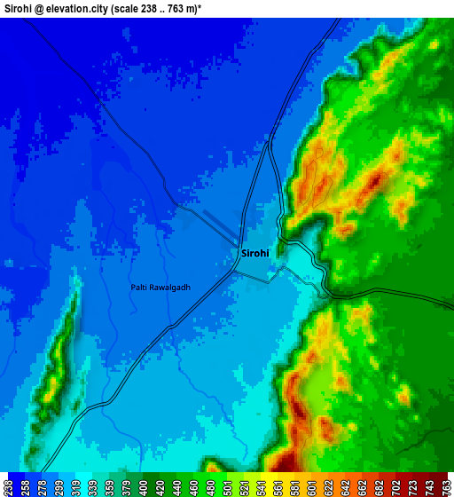
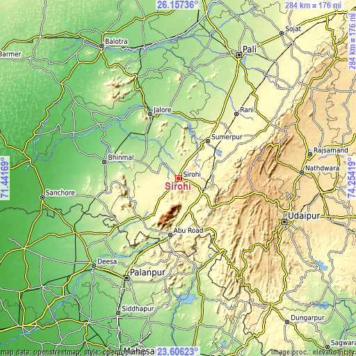
These maps also provides idea of topography and contour of this city, they are displayed at different zoom levels. More info about maps, scale and edge coordinates you can find below images.
| \ | Map #1 | Map #2 | Topo.Map |
| Scale [m] | 260..673 m | 238..763 m | × |
| Scale [ft] | 853..2208 ft | 781..2503 ft | × |
| Average | 329.9 m = 1082 ft | 351.1 m = 1152 ft | × |
| Width | 8.86 km = 5.5 mi | 17.73 km = 11 mi | 283.7 km = 176.3 mi |
| Height | 8.87 km = 5.5 mi | 17.73 km = 11 mi | 283.7 km = 176.3 mi |
| ↑Max Latitude | 24.928238° | 24.968082° | 26.15736° |
| Latitude at center | 24.88838° | 24.88838° | 24.88838° |
| ↓Min Latitude | 24.848509° | 24.808626° | 23.60623° |
| ← Min Longitude | 72.803995° | 72.760049° | 71.44169° |
| Longitude center | 72.84794° | 72.84794° | 72.84794° |
| →Max Longitude | 72.891885° | 72.935831° | 74.25419° |
Nearby cities:
Cities around Sirohi sort by population:
• Pālanpur elevation 230 m
89.9 km,  207°
207°
• Ābu Road 263 m
45.9 km,  188°
188°
• Jalor 172 m
56 km,  335°
335°
• Bhīnmāl 153 m
59.4 km,  281°
281°
• Sheoganj 274 m
35.6 km,  38°
38°
• Sādri 360 m
69.3 km,  61°
61°
• Ābu 1181 m
35.3 km,  201°
201°
• Dhanera 137 m
93.3 km,  243°
243°
• Pindwāra 375 m
23.2 km,  115°
115°
• Bāli 299 m
56.3 km,  52°
52°
• Takhatgarh 224 m
50.8 km,  18°
18°
• Rāni 281 m
69.2 km, 42°
Multilingual:
 En español:
Sirohi elevación 294 m.
 En France:
Sirohi élévation 294 m.


Sources and notes:
- [note 1] Map square and city borders are not equal. Map elevation data is calculated only from area inside that square.
- [src 1] Elevation data from geonames database provided with same terms of usage.
- [src 2] The elevation map of Sirohi is generated using elevation data from NASA's 3 arcsec (90m) resolution SRTM data.
- [src 3] Base (background) map © OpenStreetMap contributors tiles are generated by Geofabrik and OpenTopoMap.
Copyright & License:
This Sirohi Elevation Map is licensed under CC BY-SA. You may reuse any part from this page, if you give a proper credit by linking to this URL:
 More info on terms of use page.