Sītāmau elevation
Sītāmau (Madhya Pradesh, Mandsaur), India elevation is 484 meters and Sītāmau elevation in feet is 1588 ft above sea level [src 1]. Sītāmau is a populated place (feature code) with elevation that is 191 meters (627 ft) bigger than average city elevation in India.
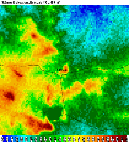
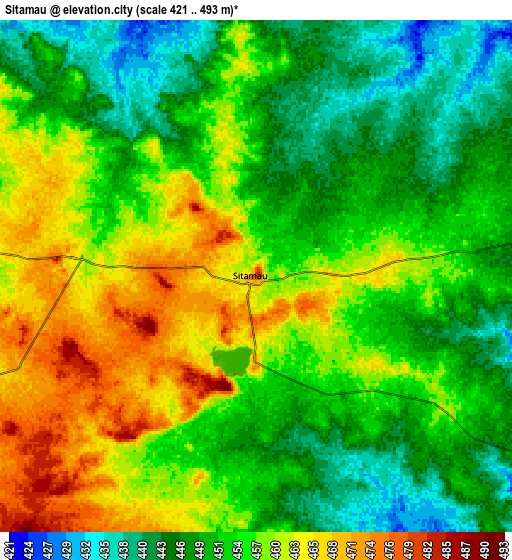
Below is the Elevation map of Sītāmau, which displays elevation range with different colors. Scale of the first map is from 438 to 493 m (1437 to 1617 ft) with average elevation of 460.9 meters (=1512 ft) [note 1]
These maps also provides idea of topography and contour of this city, they are displayed at different zoom levels. More info about maps, scale and edge coordinates you can find below images.
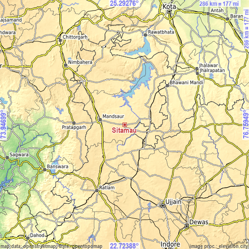
| \ | Map #1 | Map #2 | Topo.Map |
| Scale [m] | 438..493 m | 421..493 m | × |
| Scale [ft] | 1437..1617 ft | 1381..1617 ft | × |
| Average | 460.9 m = 1512 ft | 454.2 m = 1490 ft | × |
| Width | 8.93 km = 5.5 mi | 17.85 km = 11.1 mi | 285.6 km = 177.5 mi |
| Height | 8.93 km = 5.5 mi | 17.85 km = 11.1 mi | 285.6 km = 177.5 mi |
| ↑Max Latitude | 24.054865° | 24.094988° | 25.29276° |
| Latitude at center | 24.01473° | 24.01473° | 24.01473° |
| ↓Min Latitude | 23.974582° | 23.934422° | 22.72388° |
| ← Min Longitude | 75.309295° | 75.265349° | 73.94699° |
| Longitude center | 75.35324° | 75.35324° | 75.35324° |
| →Max Longitude | 75.397185° | 75.441131° | 76.75949° |
Nearby cities:
Cities around Sītāmau sort by population:
• Mandsaur elevation 440 m
29.5 km,  282°
282°
• Jaorā 473 m
47.8 km,  208°
208°
• Pratāpgarh 498 m
58.1 km,  271°
271°
• Manāsa 447 m
55.8 km,  337°
337°
• Alot 448 m
34.8 km,  143°
143°
• Shāmgarh 469 m
34.8 km,  56°
56°
• Rāmpura 411 m
51.1 km,  9°
9°
• Tāl 455 m
33 km,  174°
174°
• Jīran 485 m
57.2 km,  304°
304°
• Nārāyangarh 445 m
41.9 km,  312°
312°
• Malhārgarh 463 m
47.4 km, 308°
• Gogāpur 491 m
53.5 km,  161°
161°
Multilingual:
 En español:
Sītāmau elevación 484 m.
 En France:
Sītāmau élévation 484 m.


Sources and notes:
- [note 1] Map square and city borders are not equal. Map elevation data is calculated only from area inside that square.
- [src 1] Elevation data from geonames database provided with same terms of usage.
- [src 2] The elevation map of Sītāmau is generated using elevation data from NASA's 3 arcsec (90m) resolution SRTM data.
- [src 3] Base (background) map © OpenStreetMap contributors tiles are generated by Geofabrik and OpenTopoMap.
Copyright & License:
This Sītāmau Elevation Map is licensed under CC BY-SA. You may reuse any part from this page, if you give a proper credit by linking to this URL:
 More info on terms of use page.