Someshwar elevation
Someshwar (Karnataka, Udupi), India elevation is 134 meters and Someshwar elevation in feet is 440 ft above sea level [src 1]. Someshwar is a populated place (feature code) with elevation that is 159 meters (522 ft) smaller than average city elevation in India.
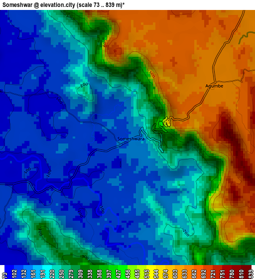
Below is the Elevation map of Someshwar, which displays elevation range with different colors. Scale of the first map is from 73 to 839 m (240 to 2753 ft) with average elevation of 316.1 meters (=1037 ft) [note 1]
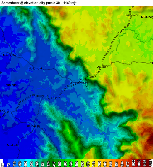
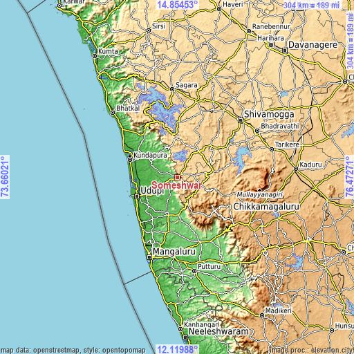
These maps also provides idea of topography and contour of this city, they are displayed at different zoom levels. More info about maps, scale and edge coordinates you can find below images.
| \ | Map #1 | Map #2 | Topo.Map |
| Scale [m] | 73..839 m | 30..1149 m | × |
| Scale [ft] | 240..2753 ft | 98..3770 ft | × |
| Average | 316.1 m = 1037 ft | 379.5 m = 1245 ft | × |
| Width | 9.5 km = 5.9 mi | 19.01 km = 11.8 mi | 304.1 km = 189 mi |
| Height | 9.5 km = 5.9 mi | 19.01 km = 11.8 mi | 304.1 km = 189 mi |
| ↑Max Latitude | 13.533849° | 13.57657° | 14.85453° |
| Latitude at center | 13.49112° | 13.49112° | 13.49112° |
| ↓Min Latitude | 13.448383° | 13.405639° | 12.11988° |
| ← Min Longitude | 75.022515° | 74.978569° | 73.66021° |
| Longitude center | 75.06646° | 75.06646° | 75.06646° |
| →Max Longitude | 75.110405° | 75.154351° | 76.47271° |
Nearby cities:
Cities around Someshwar sort by population:
• Udupi elevation 33 m
38.8 km,  243°
243°
• Manipal 90 m
34.4 km, 242°
• Coondapoor 17 m
43.6 km,  290°
290°
• Kārkala 93 m
31.8 km,  194°
194°
• Malpe 12 m
42.2 km,  248°
248°
• Tīrthahalli 620 m
29.2 km,  41°
41°
• Gangolli 11 m
46.3 km, 292°
• Hosanagara 589 m
47 km,  359°
359°
• Koppa 778 m
32.4 km,  82°
82°
• Sringeri 644 m
21.8 km,  112°
112°
• Hosangadi 103 m
26 km,  332°
332°
• Pāngāla 15 m
43.5 km,  231°
231°
Multilingual:
 En español:
Someshwar elevación 134 m.
 En France:
Someshwar élévation 134 m.
 Auf Deutsch:
Someshwar höhe über dem Meeresspiegel ist 134 m.

Sources and notes:
- [note 1] Map square and city borders are not equal. Map elevation data is calculated only from area inside that square.
- [src 1] Elevation data from geonames database provided with same terms of usage.
- [src 2] The elevation map of Someshwar is generated using elevation data from NASA's 3 arcsec (90m) resolution SRTM data.
- [src 3] Base (background) map © OpenStreetMap contributors tiles are generated by Geofabrik and OpenTopoMap.
Copyright & License:
This Someshwar Elevation Map is licensed under CC BY-SA. You may reuse any part from this page, if you give a proper credit by linking to this URL:
 More info on terms of use page.