Thenkasi elevation
Thenkasi (Tamil Nadu, Tirunelveli Kattabo), India elevation is 170 meters and Thenkasi elevation in feet is 558 ft above sea level [src 1]. Thenkasi is a populated place (feature code) with elevation that is 123 meters (404 ft) smaller than average city elevation in India.
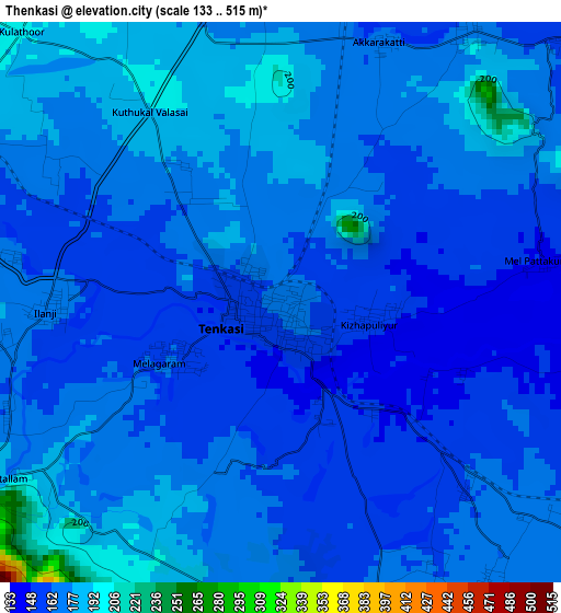
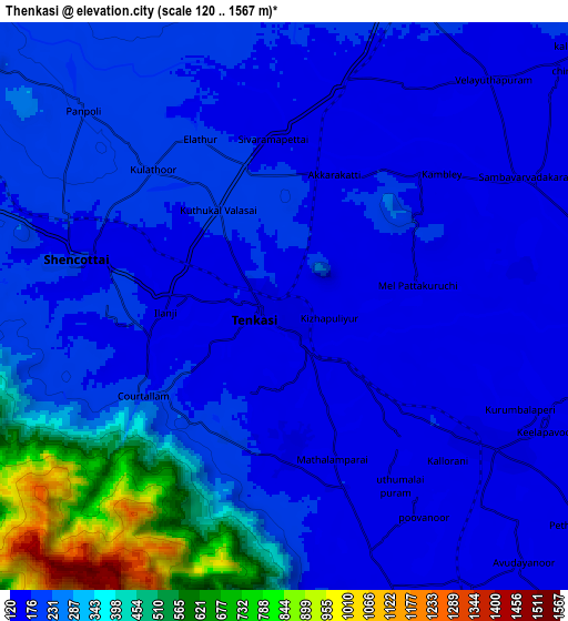
Below is the Elevation map of Thenkasi, which displays elevation range with different colors. Scale of the first map is from 133 to 515 m (436 to 1690 ft) with average elevation of 167.7 meters (=550 ft) [note 1]
These maps also provides idea of topography and contour of this city, they are displayed at different zoom levels. More info about maps, scale and edge coordinates you can find below images.
| \ | Map #1 | Map #2 | Topo.Map |
| Scale [m] | 133..515 m | 120..1567 m | × |
| Scale [ft] | 436..1690 ft | 394..5141 ft | × |
| Average | 167.7 m = 550 ft | 250.4 m = 822 ft | × |
| Width | 9.65 km = 6 mi | 19.31 km = 12 mi | 308.9 km = 191.9 mi |
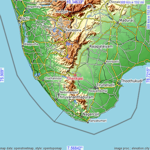
| Height | 9.65 km = 6 mi | 19.31 km = 12 mi | 308.9 km = 191.9 mi |
| ↑Max Latitude | 9.003436° | 9.046838° | 10.34633° |
| Latitude at center | 8.96003° | 8.96003° | 8.96003° |
| ↓Min Latitude | 8.916618° | 8.873202° | 7.56842° |
| ← Min Longitude | 77.271305° | 77.227359° | 75.909° |
| Longitude center | 77.31525° | 77.31525° | 77.31525° |
| →Max Longitude | 77.359195° | 77.403141° | 78.7215° |
Nearby cities:
Cities around Thenkasi sort by population:
• Kadayanallur elevation 195 m
12.9 km,  12°
12°
• Puliyangudi 204 m
25.6 km,  20°
20°
• Punalūr 38 m
43.6 km,  278°
278°
• Ambasamudram 68 m
31.5 km,  151°
151°
• Sūrandai 136 m
11.6 km,  81°
81°
• Ālangulam 125 m
22.9 km,  117°
117°
• Kallidaikurichi 72 m
34.7 km, 151°
• Sivagiri 175 m
44.6 km, 16°
• Vadakku Viravanallur 66 m
36.8 km,  142°
142°
• Vāsudevanallūr 181 m
33.1 km, 18°
• Kalugumalai 117 m
47.8 km,  63°
63°
• Kuttālam 217 m
6 km,  236°
236°
Multilingual:
 En español:
Thenkasi elevación 170 m.
 En France:
Thenkasi élévation 170 m.
 Auf Deutsch:
Thenkasi höhe über dem Meeresspiegel ist 170 m.

Sources and notes:
- [note 1] Map square and city borders are not equal. Map elevation data is calculated only from area inside that square.
- [src 1] Elevation data from geonames database provided with same terms of usage.
- [src 2] The elevation map of Thenkasi is generated using elevation data from NASA's 3 arcsec (90m) resolution SRTM data.
- [src 3] Base (background) map © OpenStreetMap contributors tiles are generated by Geofabrik and OpenTopoMap.
Copyright & License:
This Thenkasi Elevation Map is licensed under CC BY-SA. You may reuse any part from this page, if you give a proper credit by linking to this URL:
 More info on terms of use page.