Tanjore elevation
Tanjore (Tamil Nadu, Thanjavur), India elevation is 57 meters and Tanjore elevation in feet is 187 ft above sea level [src 1]. Tanjore is a populated place (feature code) with elevation that is 236 meters (774 ft) smaller than average city elevation in India.
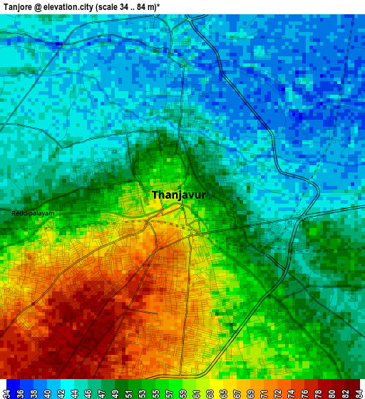
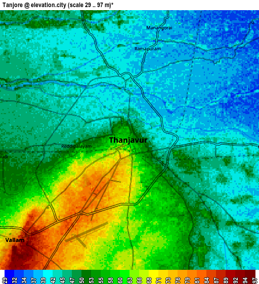
Below is the Elevation map of Tanjore, which displays elevation range with different colors. Scale of the first map is from 34 to 84 m (112 to 276 ft) with average elevation of 52.2 meters (=171 ft) [note 1]
These maps also provides idea of topography and contour of this city, they are displayed at different zoom levels. More info about maps, scale and edge coordinates you can find below images.
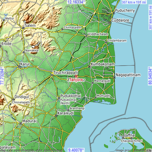
| \ | Map #1 | Map #2 | Topo.Map |
| Scale [m] | 34..84 m | 29..97 m | × |
| Scale [ft] | 112..276 ft | 95..318 ft | × |
| Average | 52.2 m = 171 ft | 50.4 m = 165 ft | × |
| Width | 9.6 km = 6 mi | 19.2 km = 11.9 mi | 307.2 km = 190.9 mi |
| Height | 9.6 km = 6 mi | 19.2 km = 11.9 mi | 307.2 km = 190.9 mi |
| ↑Max Latitude | 10.828396° | 10.871556° | 12.16334° |
| Latitude at center | 10.78523° | 10.78523° | 10.78523° |
| ↓Min Latitude | 10.742058° | 10.69888° | 9.40078° |
| ← Min Longitude | 79.095145° | 79.051199° | 77.73284° |
| Longitude center | 79.13909° | 79.13909° | 79.13909° |
| →Max Longitude | 79.183035° | 79.226981° | 80.54534° |
Nearby cities:
Cities around Tanjore sort by population:
• Kumbakonam elevation 31 m
33.8 km,  54°
54°
• Papanasam 37 m
21.3 km,  42°
42°
• Vallam 80 m
11.3 km,  230°
230°
• Ayyampettāi 37 m
13.7 km,  19°
19°
• Ammāpettai 35 m
19.8 km,  86°
86°
• Thiruvaiyaru 42 m
11.7 km,  340°
340°
• Thirukattupalli 50 m
21 km,  288°
288°
• Karambakkudi 52 m
36.3 km,  179°
179°
• Valangaiman 30 m
30.1 km,  67°
67°
• Pullambādi 65 m
30.4 km,  304°
304°
• Needamangalam 21 m
30.6 km, 92°
• Swāmimalai 36 m
28.3 km, 47°
Multilingual:
 En español:
Tanjore elevación 57 m.
 En France:
Tanjavûr élévation 57 m.


Sources and notes:
- [note 1] Map square and city borders are not equal. Map elevation data is calculated only from area inside that square.
- [src 1] Elevation data from geonames database provided with same terms of usage.
- [src 2] The elevation map of Tanjore is generated using elevation data from NASA's 3 arcsec (90m) resolution SRTM data.
- [src 3] Base (background) map © OpenStreetMap contributors tiles are generated by Geofabrik and OpenTopoMap.
Copyright & License:
This Tanjore Elevation Map is licensed under CC BY-SA. You may reuse any part from this page, if you give a proper credit by linking to this URL:
 More info on terms of use page.