Thiruvananthapuram elevation
Thiruvananthapuram (Kerala), India elevation is 18 meters and Thiruvananthapuram elevation in feet is 59 ft above sea level [src 1]. Thiruvananthapuram is a seat of a first-order administrative division (feature code) with elevation that is 275 meters (902 ft) smaller than average city elevation in India.
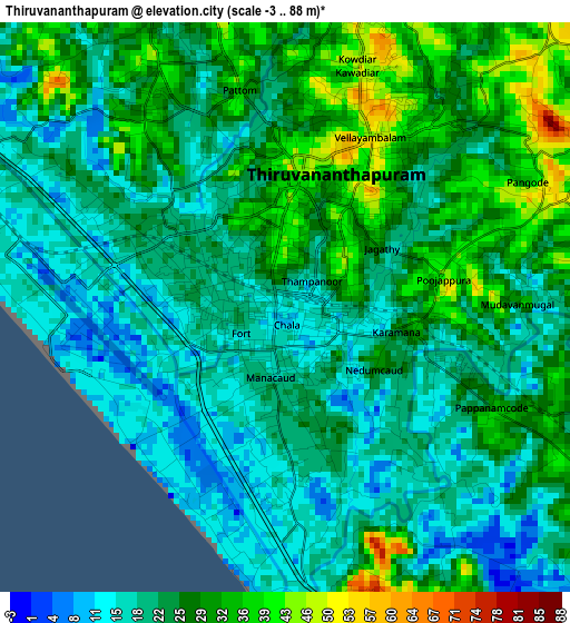
Below is the Elevation map of Thiruvananthapuram, which displays elevation range with different colors. Scale of the first map is from -3 to 88 m (-10 to 289 ft) with average elevation of 23.6 meters (=77 ft) [note 1]
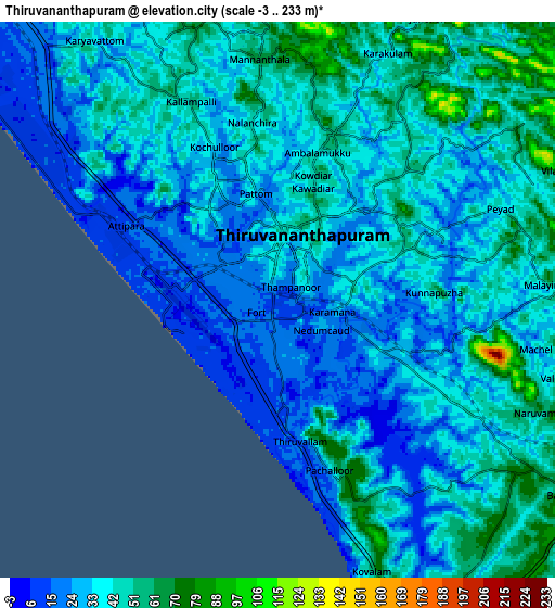
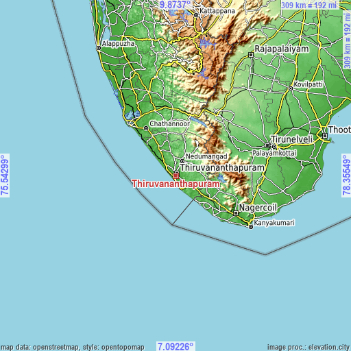
These maps also provides idea of topography and contour of this city, they are displayed at different zoom levels. More info about maps, scale and edge coordinates you can find below images.
| \ | Map #1 | Map #2 | Topo.Map |
| Scale [m] | -3..88 m | -3..233 m | × |
| Scale [ft] | -10..289 ft | -10..764 ft | × |
| Average | 23.6 m = 77 ft | 37 m = 121 ft | × |
| Width | 9.67 km = 6 mi | 19.33 km = 12 mi | 309.3 km = 192.2 mi |
| Height | 9.67 km = 6 mi | 19.33 km = 12 mi | 309.3 km = 192.2 mi |
| ↑Max Latitude | 8.528962° | 8.572419° | 9.8737° |
| Latitude at center | 8.4855° | 8.4855° | 8.4855° |
| ↓Min Latitude | 8.442033° | 8.398562° | 7.09226° |
| ← Min Longitude | 76.905295° | 76.861349° | 75.54299° |
| Longitude center | 76.94924° | 76.94924° | 76.94924° |
| →Max Longitude | 76.993185° | 77.037131° | 78.35549° |
Nearby cities:
Cities around Thiruvananthapuram sort by population:
• Neyyāttinkara elevation 26 m
17.9 km,  122°
122°
• Nedumangād 57 m
14.2 km,  23°
23°
• Varkala 48 m
37.6 km,  317°
317°
• Paravūr Tekkumbhāgam 23 m
46.2 km, 318°
• Vettūr 30 m
35.6 km, 316°
• Attingal 43 m
27.7 km,  327°
327°
• Kadakkavoor 15 m
29.4 km, 317°
• Colachel 36 m
48.1 km,  135°
135°
• Kuzhithurai 57 m
32.6 km, 124°
• Padmanābhapuram 35 m
49.3 km, 122°
• Eraniel 38 m
51 km,  127°
127°
• Kovalam 30 m
14.2 km,  158°
158°
Multilingual:
 En español:
Thiruvananthapuram elevación 18 m.
 En France:
Thiruvananthapuram élévation 18 m.
 Auf Deutsch:
Thiruvananthapuram höhe über dem Meeresspiegel ist 18 m.

Sources and notes:
- [note 1] Map square and city borders are not equal. Map elevation data is calculated only from area inside that square.
- [src 1] Elevation data from geonames database provided with same terms of usage.
- [src 2] The elevation map of Thiruvananthapuram is generated using elevation data from NASA's 3 arcsec (90m) resolution SRTM data.
- [src 3] Base (background) map © OpenStreetMap contributors tiles are generated by Geofabrik and OpenTopoMap.
Copyright & License:
This Thiruvananthapuram Elevation Map is licensed under CC BY-SA. You may reuse any part from this page, if you give a proper credit by linking to this URL:
 More info on terms of use page.