Beersheba elevation
Beersheba (Southern District), Israel elevation is 285 meters and Beersheba elevation in feet is 935 ft above sea level [src 1]. Beersheba is a seat of a first-order administrative division (feature code) with elevation that is 74 meters (243 ft) bigger than average city elevation in Israel.
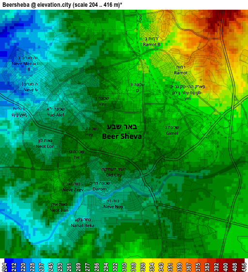
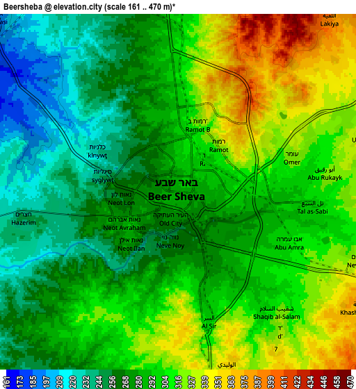
Below is the Elevation map of Beersheba, which displays elevation range with different colors. Scale of the first map is from 204 to 416 m (669 to 1365 ft) with average elevation of 281.2 meters (=923 ft) [note 1]
These maps also provides idea of topography and contour of this city, they are displayed at different zoom levels. More info about maps, scale and edge coordinates you can find below images.
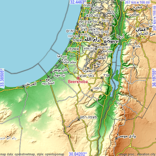
| \ | Map #1 | Map #2 | Topo.Map |
| Scale [m] | 204..416 m | 161..470 m | × |
| Scale [ft] | 669..1365 ft | 528..1542 ft | × |
| Average | 281.2 m = 923 ft | 290.6 m = 953 ft | × |
| Width | 8.35 km = 5.2 mi | 16.71 km = 10.4 mi | 267.3 km = 166.1 mi |
| Height | 8.35 km = 5.2 mi | 16.71 km = 10.4 mi | 267.3 km = 166.1 mi |
| ↑Max Latitude | 31.289371° | 31.326917° | 32.4463° |
| Latitude at center | 31.25181° | 31.25181° | 31.25181° |
| ↓Min Latitude | 31.214234° | 31.176643° | 30.04202° |
| ← Min Longitude | 34.747355° | 34.703409° | 33.38505° |
| Longitude center | 34.7913° | 34.7913° | 34.7913° |
| →Max Longitude | 34.835245° | 34.879191° | 36.19755° |
Nearby cities:
Cities around Beersheba sort by population:
• Ashkelon elevation 42 m
50.9 km,  335°
335°
• Qiryat Gat 133 m
39.9 km,  356°
356°
• Dimona 551 m
30.5 km,  131°
131°
• Netivot 151 m
27 km,  314°
314°
• Ofaqim 137 m
17.7 km,  293°
293°
• Arad 613 m
40.1 km,  88°
88°
• Sederot 90 m
35.5 km,  328°
328°
• Rahat 228 m
16.3 km,  348°
348°
• Yeroẖam 499 m
32.2 km,  155°
155°
• Lehavim 317 m
13.7 km,  9°
9°
• ‘En Boqeq -380 m
54.6 km,  96°
96°
• Midreshet Ben-Gurion 480 m
44.5 km,  180°
180°
Multilingual:
 En español:
Be'er Sheva, Beerseba elevación 285 m.
 En France:
Beer-Sheva élévation 285 m.
 Auf Deutsch:
Be’er Scheva, Biʾr as-Sabʿ höhe über dem Meeresspiegel ist 285 m.

Sources and notes:
- [note 1] Map square and city borders are not equal. Map elevation data is calculated only from area inside that square.
- [src 1] Elevation data from geonames database provided with same terms of usage.
- [src 2] The elevation map of Beersheba is generated using elevation data from NASA's 3 arcsec (90m) resolution SRTM data.
- [src 3] Base (background) map © OpenStreetMap contributors tiles are generated by Geofabrik and OpenTopoMap.
Copyright & License:
This Beersheba Elevation Map is licensed under CC BY-SA. You may reuse any part from this page, if you give a proper credit by linking to this URL:
 More info on terms of use page.