Reẖovot elevation
Reẖovot (Central District), Israel elevation is 47 meters and Reẖovot elevation in feet is 154 ft above sea level [src 1]. Reẖovot is a populated place (feature code) with elevation that is 164 meters (538 ft) smaller than average city elevation in Israel.
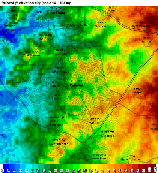
Below is the Elevation map of Reẖovot, which displays elevation range with different colors. Scale of the first map is from 14 to 103 m (46 to 338 ft) with average elevation of 55.1 meters (=181 ft) [note 1]
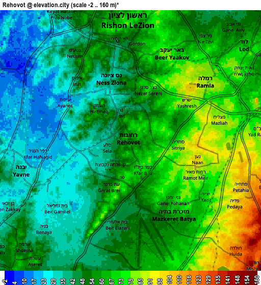
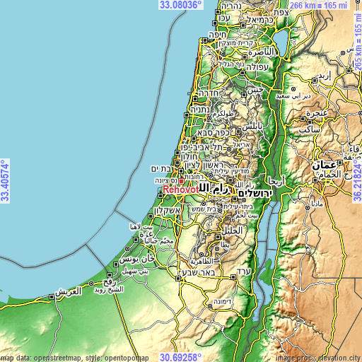
These maps also provides idea of topography and contour of this city, they are displayed at different zoom levels. More info about maps, scale and edge coordinates you can find below images.
| \ | Map #1 | Map #2 | Topo.Map |
| Scale [m] | 14..103 m | -2..160 m | × |
| Scale [ft] | 46..338 ft | -7..525 ft | × |
| Average | 55.1 m = 181 ft | 55.5 m = 182 ft | × |
| Width | 8.3 km = 5.2 mi | 16.59 km = 10.3 mi | 265.5 km = 165 mi |
| Height | 8.3 km = 5.2 mi | 16.59 km = 10.3 mi | 265.5 km = 165 mi |
| ↑Max Latitude | 31.931513° | 31.968801° | 33.08036° |
| Latitude at center | 31.89421° | 31.89421° | 31.89421° |
| ↓Min Latitude | 31.856892° | 31.819558° | 30.69258° |
| ← Min Longitude | 34.768045° | 34.724099° | 33.40574° |
| Longitude center | 34.81199° | 34.81199° | 34.81199° |
| →Max Longitude | 34.855935° | 34.899881° | 36.21824° |
Nearby cities:
Cities around Reẖovot sort by population:
• Rishon LeẔiyyon elevation 56 m
8.8 km,  345°
345°
• H̱olon 31 m
13.3 km, 346°
• Lod 68 m
9.4 km,  51°
51°
• Ramla 83 m
6.4 km, 52°
• Ness Ziona 35 m
4.1 km,  342°
342°
• Yavné 37 m
7 km,  255°
255°
• Gedera 64 m
9.4 km,  198°
198°
• Azor 25 m
14.5 km,  357°
357°
• Mazkeret Batya 75 m
5.6 km,  144°
144°
• Bnei Ayish 61 m
13.6 km,  205°
205°
• Bet Dagan 36 m
12.1 km,  7°
7°
• Kefar H̱abad 43 m
11.1 km,  19°
19°
Multilingual:
 En español:
Rejovot elevación 47 m.
 En France:
Rehovot élévation 47 m.


Sources and notes:
- [note 1] Map square and city borders are not equal. Map elevation data is calculated only from area inside that square.
- [src 1] Elevation data from geonames database provided with same terms of usage.
- [src 2] The elevation map of Reẖovot is generated using elevation data from NASA's 3 arcsec (90m) resolution SRTM data.
- [src 3] Base (background) map © OpenStreetMap contributors tiles are generated by Geofabrik and OpenTopoMap.
Copyright & License:
This Reẖovot Elevation Map is licensed under CC BY-SA. You may reuse any part from this page, if you give a proper credit by linking to this URL:
 More info on terms of use page.