Bet Dagan elevation
Bet Dagan (Central District), Israel elevation is 36 meters and Bet Dagan elevation in feet is 118 ft above sea level [src 1]. Bet Dagan is a populated place (feature code) with elevation that is 175 meters (574 ft) smaller than average city elevation in Israel.
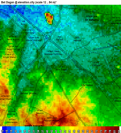
Below is the Elevation map of Bet Dagan, which displays elevation range with different colors. Scale of the first map is from 12 to 84 m (39 to 276 ft) with average elevation of 39.2 meters (=129 ft) [note 1]
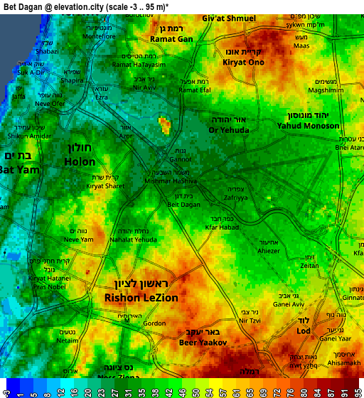
These maps also provides idea of topography and contour of this city, they are displayed at different zoom levels. More info about maps, scale and edge coordinates you can find below images.
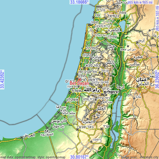
| \ | Map #1 | Map #2 | Topo.Map |
| Scale [m] | 12..84 m | -3..95 m | × |
| Scale [ft] | 39..276 ft | -10..312 ft | × |
| Average | 39.2 m = 129 ft | 43.7 m = 143 ft | × |
| Width | 8.29 km = 5.2 mi | 16.57 km = 10.3 mi | 265.2 km = 164.8 mi |
| Height | 8.29 km = 5.2 mi | 16.57 km = 10.3 mi | 265.2 km = 164.8 mi |
| ↑Max Latitude | 32.039169° | 32.076414° | 33.18665° |
| Latitude at center | 32.00191° | 32.00191° | 32.00191° |
| ↓Min Latitude | 31.964635° | 31.927346° | 30.80167° |
| ← Min Longitude | 34.785825° | 34.741879° | 33.42352° |
| Longitude center | 34.82977° | 34.82977° | 34.82977° |
| →Max Longitude | 34.873715° | 34.917661° | 36.23602° |
Nearby cities:
Cities around Bet Dagan sort by population:
• Rishon LeẔiyyon elevation 56 m
5.1 km,  227°
227°
• H̱olon 31 m
4.9 km,  281°
281°
• Bat Yam 32 m
7.7 km,  288°
288°
• Lod 68 m
8.4 km,  137°
137°
• Givatayim 50 m
8 km,  348°
348°
• Or Yehuda 33 m
4 km,  41°
41°
• Yehud-Monosson 36 m
5.5 km,  57°
57°
• Yehud 44 m
6.7 km, 58°
• Azor 25 m
3.3 km,  318°
318°
• Ganei Tikva 79 m
7.6 km,  32°
32°
• Kefar H̱abad 43 m
2.6 km,  127°
127°
• Savyon 75 m
7 km, 40°
Multilingual:
 En español:
Bet Dagan elevación 36 m.
 En France:
Bet Dagan élévation 36 m.
 Auf Deutsch:
Bet Dagan höhe über dem Meeresspiegel ist 36 m.

Sources and notes:
- [note 1] Map square and city borders are not equal. Map elevation data is calculated only from area inside that square.
- [src 1] Elevation data from geonames database provided with same terms of usage.
- [src 2] The elevation map of Bet Dagan is generated using elevation data from NASA's 3 arcsec (90m) resolution SRTM data.
- [src 3] Base (background) map © OpenStreetMap contributors tiles are generated by Geofabrik and OpenTopoMap.
Copyright & License:
This Bet Dagan Elevation Map is licensed under CC BY-SA. You may reuse any part from this page, if you give a proper credit by linking to this URL:
 More info on terms of use page.