Bray elevation
Bray (Leinster, Wicklow), Ireland elevation is 7 meters and Bray elevation in feet is 23 ft above sea level [src 1]. Bray is a populated place (feature code) with elevation that is 44 meters (144 ft) smaller than average city elevation in Ireland.
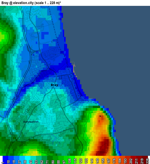
Below is the Elevation map of Bray, which displays elevation range with different colors. Scale of the first map is from 1 to 228 m (3 to 748 ft) with average elevation of 53.6 meters (=176 ft) [note 1]
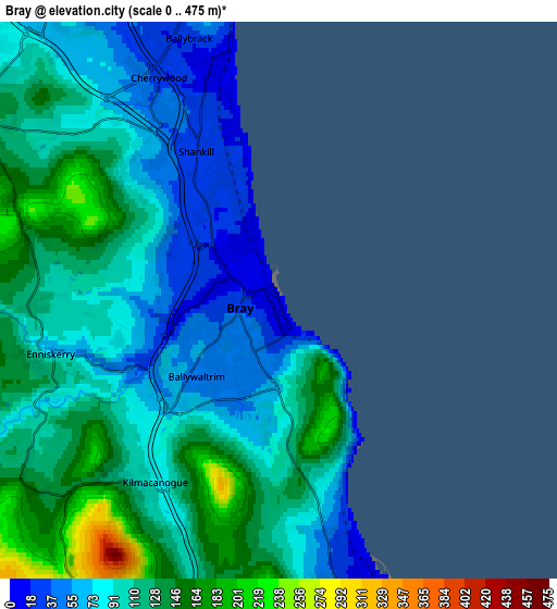
These maps also provides idea of topography and contour of this city, they are displayed at different zoom levels. More info about maps, scale and edge coordinates you can find below images.
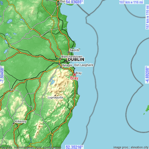
| \ | Map #1 | Map #2 | Topo.Map |
| Scale [m] | 1..228 m | 0..475 m | × |
| Scale [ft] | 3..748 ft | 0..1558 ft | × |
| Average | 53.6 m = 176 ft | 102.7 m = 337 ft | × |
| Width | 5.85 km = 3.6 mi | 11.71 km = 7.3 mi | 187.3 km = 116.4 mi |
| Height | 5.85 km = 3.6 mi | 11.71 km = 7.3 mi | 187.3 km = 116.4 mi |
| ↑Max Latitude | 53.229094° | 53.255393° | 54.03685° |
| Latitude at center | 53.20278° | 53.20278° | 53.20278° |
| ↓Min Latitude | 53.176449° | 53.150103° | 52.35216° |
| ← Min Longitude | -6.142275° | -6.186221° | -7.50458° |
| Longitude center | -6.09833° | -6.09833° | -6.09833° |
| →Max Longitude | -6.054385° | -6.010439° | -4.69208° |
Nearby cities:
Cities around Bray sort by population:
• Greystones elevation 19 m
7.3 km,  161°
161°
• Foxrock 71 m
8.7 km,  324°
324°
• Shankill 33 m
3.1 km,  326°
326°
• Cabinteely 41 m
8.5 km, 330°
• Little Bray 11 m
1.5 km,  277°
277°
• Sallynoggin 42 m
8.9 km,  341°
341°
• Dalkey 19 m
8.4 km,  359°
359°
• Loughlinstown 17 m
5.1 km, 333°
• Enniskerry 69 m
4.9 km,  256°
256°
• Charlesland 12 m
8.7 km, 164°
• Kilpedder 93 m
10.4 km,  183°
183°
• Kilmacanoge 90 m
4.6 km,  210°
210°
Multilingual:
 En español:
Bray elevación 7 m.
 En France:
Bray élévation 7 m.


Sources and notes:
- [note 1] Map square and city borders are not equal. Map elevation data is calculated only from area inside that square.
- [src 1] Elevation data from geonames database provided with same terms of usage.
- [src 2] The elevation map of Bray is generated using elevation data from NASA's 3 arcsec (90m) resolution SRTM data.
- [src 3] Base (background) map © OpenStreetMap contributors tiles are generated by Geofabrik and OpenTopoMap.
Copyright & License:
This Bray Elevation Map is licensed under CC BY-SA. You may reuse any part from this page, if you give a proper credit by linking to this URL:
 More info on terms of use page.