Clondalkin elevation
Clondalkin (Leinster, South Dublin), Ireland elevation is 60 meters and Clondalkin elevation in feet is 197 ft above sea level [src 1]. Clondalkin is a populated place (feature code) with elevation that is 9 meters (30 ft) bigger than average city elevation in Ireland.
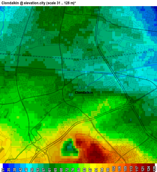
Below is the Elevation map of Clondalkin, which displays elevation range with different colors. Scale of the first map is from 31 to 128 m (102 to 420 ft) with average elevation of 67.2 meters (=220 ft) [note 1]
These maps also provides idea of topography and contour of this city, they are displayed at different zoom levels. More info about maps, scale and edge coordinates you can find below images.
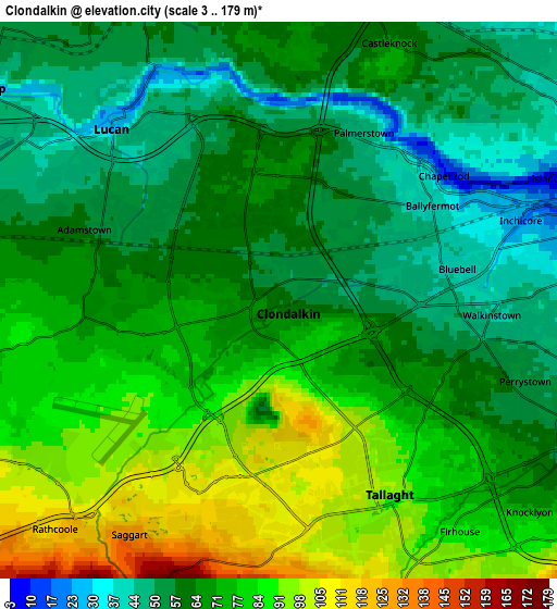
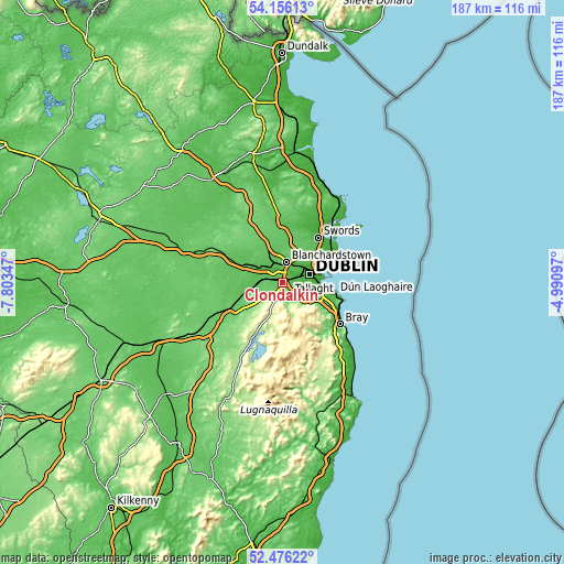
| \ | Map #1 | Map #2 | Topo.Map |
| Scale [m] | 31..128 m | 3..179 m | × |
| Scale [ft] | 102..420 ft | 10..587 ft | × |
| Average | 67.2 m = 220 ft | 69.3 m = 227 ft | × |
| Width | 5.84 km = 3.6 mi | 11.67 km = 7.3 mi | 186.8 km = 116.1 mi |
| Height | 5.84 km = 3.6 mi | 11.67 km = 7.3 mi | 186.8 km = 116.1 mi |
| ↑Max Latitude | 53.35068° | 53.376903° | 54.15613° |
| Latitude at center | 53.32444° | 53.32444° | 53.32444° |
| ↓Min Latitude | 53.298184° | 53.271912° | 52.47622° |
| ← Min Longitude | -6.441165° | -6.485111° | -7.80347° |
| Longitude center | -6.39722° | -6.39722° | -6.39722° |
| →Max Longitude | -6.353275° | -6.309329° | -4.99097° |
Nearby cities:
Cities around Clondalkin sort by population:
• Tallaght elevation 103 m
4.6 km,  159°
159°
• Lucan 25 m
5 km,  317°
317°
• Crumlin 49 m
5.5 km,  93°
93°
• Jobstown 116 m
5.1 km,  188°
188°
• Oldbawn 104 m
5.8 km, 160°
• Ballyfermot 17 m
3.5 km,  54°
54°
• Castleknock 61 m
6 km,  21°
21°
• Cherry Orchard 54 m
1.8 km,  44°
44°
• Palmerstown 51 m
3.1 km, 24°
• Firhouse 84 m
6.1 km,  140°
140°
• Chapelizod 16 m
4.5 km, 53°
• Saggart 129 m
5.8 km,  212°
212°
Multilingual:
 En español:
Clondalkin elevación 60 m.
 En France:
Clondalkin élévation 60 m.
 Auf Deutsch:
Clondalkin höhe über dem Meeresspiegel ist 60 m.

Sources and notes:
- [note 1] Map square and city borders are not equal. Map elevation data is calculated only from area inside that square.
- [src 1] Elevation data from geonames database provided with same terms of usage.
- [src 2] The elevation map of Clondalkin is generated using elevation data from NASA's 3 arcsec (90m) resolution SRTM data.
- [src 3] Base (background) map © OpenStreetMap contributors tiles are generated by Geofabrik and OpenTopoMap.
Copyright & License:
This Clondalkin Elevation Map is licensed under CC BY-SA. You may reuse any part from this page, if you give a proper credit by linking to this URL:
 More info on terms of use page.