Arjasa elevation
Arjasa (East Java), Indonesia elevation is 31 meters and Arjasa elevation in feet is 102 ft above sea level [src 1]. Arjasa is a seat of a third-order administrative division (feature code) with elevation that is 160 meters (525 ft) smaller than average city elevation in Indonesia.
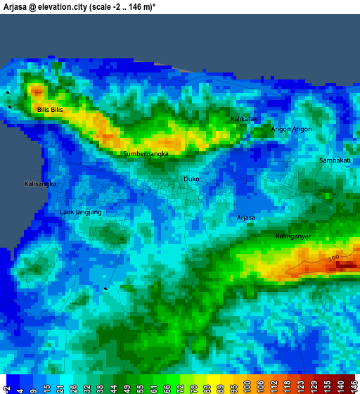
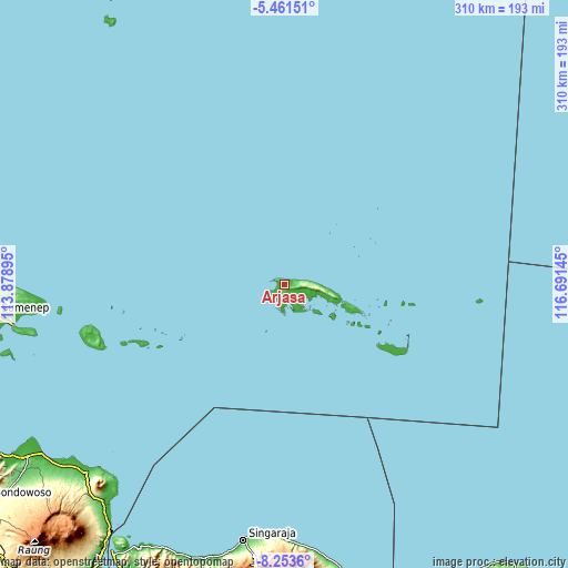
Below is the Elevation map of Arjasa, which displays elevation range with different colors. Scale of the first map is from -2 to 146 m (-7 to 479 ft) with average elevation of 31.6 meters (=104 ft) [note 1]
These maps also provides idea of topography and contour of this city, they are displayed at different zoom levels. More info about maps, scale and edge coordinates you can find below images.
| \ | Map #1 | Topo.Map |
| Scale [m] | -2..146 m | × |
| Scale [ft] | -7..479 ft | × |
| Average | 31.6 m = 104 ft | × |
| Width | 9.7 km = 6 mi | 310.5 km = 192.9 mi |
| Height | 9.7 km = 6 mi | 310.5 km = 192.9 mi |
| ↑Max Latitude | -6.815967° | -5.46151° |
| Latitude at center | -6.8596° | -6.8596° |
| ↓Min Latitude | -6.903229° | -8.2536° |
| ← Min Longitude | 115.241255° | 113.87895° |
| Longitude center | 115.2852° | 115.2852° |
| →Max Longitude | 115.329145° | 116.69145° |
Nearby cities:
Cities around Arjasa sort by population:
• Singaraja elevation 11 m
140.9 km,  188°
188°
• Kalianget 14 m
149.8 km,  261°
261°
• Lovina 5 m
145.9 km, 190°
• Sumberanyar 34 m
149.5 km,  226°
226°
• Talango 13 m
149 km, 261°
• Gapura 19 m
147.5 km, 264°
• Sukasada 110 m
143.7 km, 188°
• Dungkek 15 m
132.1 km, 264°
• Sokarame 27 m
113.1 km, 257°
• Gayam 19 m
110.6 km,  252°
252°
• Brakas 9 m
80.9 km, 246°
• Sapeken 4 m
49.2 km,  109°
109°
Multilingual:
 En español:
Arjasa elevación 31 m.
 En France:
Arjasa élévation 31 m.


Sources and notes:
- [note 1] Map square and city borders are not equal. Map elevation data is calculated only from area inside that square.
- [src 1] Elevation data from geonames database provided with same terms of usage.
- [src 2] The elevation map of Arjasa is generated using elevation data from NASA's 3 arcsec (90m) resolution SRTM data.
- [src 3] Base (background) map © OpenStreetMap contributors tiles are generated by Geofabrik and OpenTopoMap.
Copyright & License:
This Arjasa Elevation Map is licensed under CC BY-SA. You may reuse any part from this page, if you give a proper credit by linking to this URL:
 More info on terms of use page.