Banding Agung elevation
Banding Agung (South Sumatra), Indonesia elevation is 558 meters and Banding Agung elevation in feet is 1831 ft above sea level [src 1]. Banding Agung is a seat of a third-order administrative division (feature code) with elevation that is 367 meters (1204 ft) bigger than average city elevation in Indonesia.
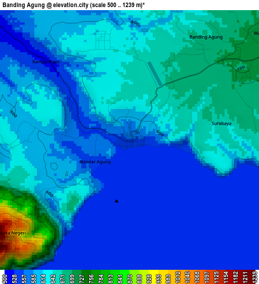
Below is the Elevation map of Banding Agung, which displays elevation range with different colors. Scale of the first map is from 500 to 1239 m (1640 to 4065 ft) with average elevation of 613.4 meters (=2012 ft) [note 1]
These maps also provides idea of topography and contour of this city, they are displayed at different zoom levels. More info about maps, scale and edge coordinates you can find below images.
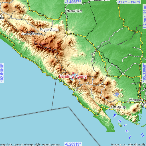
| \ | Map #1 | Topo.Map |
| Scale [m] | 500..1239 m | × |
| Scale [ft] | 1640..4065 ft | × |
| Average | 613.4 m = 2012 ft | × |
| Width | 9.74 km = 6.1 mi | 311.6 km = 193.6 mi |
| Height | 9.74 km = 6.1 mi | 311.6 km = 193.6 mi |
| ↑Max Latitude | -4.765678° | -3.40687° |
| Latitude at center | -4.80947° | -4.80947° |
| ↓Min Latitude | -4.853259° | -6.20919° |
| ← Min Longitude | 103.880485° | 102.51818° |
| Longitude center | 103.92443° | 103.92443° |
| →Max Longitude | 103.968375° | 105.33068° |
Nearby cities:
Cities around Banding Agung sort by population:
• Umbulan Kapiak elevation 237 m
67 km,  92°
92°
• Bintuhan 9 m
63.9 km,  271°
271°
• Bara Datu 179 m
63.8 km,  83°
83°
• Kasui 177 m
59.1 km, 79°
• Biha 8 m
59 km,  168°
168°
• Simpang 125 m
49.9 km,  36°
36°
• Pulauberingin 780 m
46.9 km,  317°
317°
• Krui 5 m
41.5 km,  178°
178°
• Kenali 848 m
36 km,  124°
124°
• Muara Dua 135 m
35 km,  28°
28°
• Kuripan 9 m
30.8 km,  215°
215°
• Liwa 912 m
30.2 km,  146°
146°
Multilingual:
 En español:
Banding Agung elevación 558 m.
 En France:
Banding Agung élévation 558 m.
 Auf Deutsch:
Banding Agung höhe über dem Meeresspiegel ist 558 m.

Sources and notes:
- [note 1] Map square and city borders are not equal. Map elevation data is calculated only from area inside that square.
- [src 1] Elevation data from geonames database provided with same terms of usage.
- [src 2] The elevation map of Banding Agung is generated using elevation data from NASA's 3 arcsec (90m) resolution SRTM data.
- [src 3] Base (background) map © OpenStreetMap contributors tiles are generated by Geofabrik and OpenTopoMap.
Copyright & License:
This Banding Agung Elevation Map is licensed under CC BY-SA. You may reuse any part from this page, if you give a proper credit by linking to this URL:
 More info on terms of use page.