Bandung elevation
Bandung (East Java), Indonesia elevation is 91 meters and Bandung elevation in feet is 299 ft above sea level [src 1]. Bandung is a seat of a third-order administrative division (feature code) with elevation that is 100 meters (328 ft) smaller than average city elevation in Indonesia.
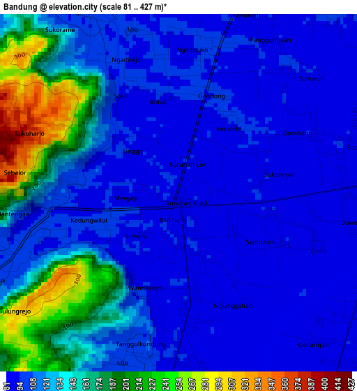
Below is the Elevation map of Bandung, which displays elevation range with different colors. Scale of the first map is from 81 to 427 m (266 to 1401 ft) with average elevation of 123.2 meters (=404 ft) [note 1]
These maps also provides idea of topography and contour of this city, they are displayed at different zoom levels. More info about maps, scale and edge coordinates you can find below images.
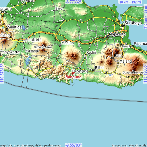
| \ | Map #1 | Topo.Map |
| Scale [m] | 81..427 m | × |
| Scale [ft] | 266..1401 ft | × |
| Average | 123.2 m = 404 ft | × |
| Width | 9.67 km = 6 mi | 309.5 km = 192.3 mi |
| Height | 9.67 km = 6 mi | 309.5 km = 192.3 mi |
| ↑Max Latitude | -8.124098° | -6.77332° |
| Latitude at center | -8.1676° | -8.1676° |
| ↓Min Latitude | -8.211097° | -9.55703° |
| ← Min Longitude | 111.740455° | 110.37815° |
| Longitude center | 111.7844° | 111.7844° |
| →Max Longitude | 111.828345° | 113.19065° |
Nearby cities:
Cities around Bandung sort by population:
• Boyolangu elevation 94 m
13.2 km,  65°
65°
• Trenggalek 113 m
13.3 km,  319°
319°
• Prigi 15 m
13.9 km,  213°
213°
• Kampak 124 m
13.6 km,  266°
266°
• Gondang 96 m
12.5 km,  33°
33°
• Tanggunggunung 331 m
11.5 km,  119°
119°
• Gandusari 108 m
9.8 km,  295°
295°
• Bendo 104 m
9.3 km,  331°
331°
• Campurdarat 91 m
7.6 km,  87°
87°
• Durenan 96 m
5.5 km,  16°
16°
• Pakel 89 m
4.9 km, 72°
• Besuki Satu 100 m
4.7 km,  192°
192°
Multilingual:
 En español:
Bandung elevación 91 m.
 En France:
Bandung élévation 91 m.


Sources and notes:
- [note 1] Map square and city borders are not equal. Map elevation data is calculated only from area inside that square.
- [src 1] Elevation data from geonames database provided with same terms of usage.
- [src 2] The elevation map of Bandung is generated using elevation data from NASA's 3 arcsec (90m) resolution SRTM data.
- [src 3] Base (background) map © OpenStreetMap contributors tiles are generated by Geofabrik and OpenTopoMap.
Copyright & License:
This Bandung Elevation Map is licensed under CC BY-SA. You may reuse any part from this page, if you give a proper credit by linking to this URL:
 More info on terms of use page.