Cianjur elevation
Cianjur (West Java), Indonesia elevation is 456 meters and Cianjur elevation in feet is 1496 ft above sea level [src 1]. Cianjur is a seat of a second-order administrative division (feature code) with elevation that is 265 meters (869 ft) bigger than average city elevation in Indonesia.
Below is the Elevation map of Cianjur, which displays elevation range with different colors. Scale of the first map is from 313 to 892 m (1027 to 2927 ft) with average elevation of 465.9 meters (=1529 ft) [note 1]
These maps also provides idea of topography and contour of this city, they are displayed at different zoom levels. More info about maps, scale and edge coordinates you can find below images.
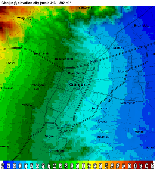
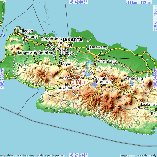
| \ | Map #1 | Topo.Map |
| Scale [m] | 313..892 m | × |
| Scale [ft] | 1027..2927 ft | × |
| Average | 465.9 m = 1529 ft | × |
| Width | 9.7 km = 6 mi | 310.5 km = 192.9 mi |
| Height | 9.7 km = 6 mi | 310.5 km = 192.9 mi |
| ↑Max Latitude | -6.778584° | -5.42403° |
| Latitude at center | -6.82222° | -6.82222° |
| ↓Min Latitude | -6.865852° | -8.21634° |
| ← Min Longitude | 107.095495° | 105.73319° |
| Longitude center | 107.13944° | 107.13944° |
| →Max Longitude | 107.183385° | 108.54569° |
Nearby cities:
Cities around Cianjur sort by population:
• Cimahi elevation 764 m
44.8 km,  97°
97°
• Sukabumi 613 m
25.8 km,  245°
245°
• Purwakarta 86 m
44.7 km,  48°
48°
• Padalarang 703 m
36.8 km,  92°
92°
• Caringin 444 m
37.4 km,  290°
290°
• Cicurug 502 m
39.7 km,  276°
276°
• Ciranjang-hilir 266 m
13 km, 88°
• Jampang Tengah 518 m
45.5 km,  235°
235°
• Nyalindung 920 m
32.6 km,  221°
221°
• Sukanagara 871 m
30.7 km,  181°
181°
• Takokak 1004 m
29.6 km,  210°
210°
• Ngamprah 269 m
15.1 km,  82°
82°
Multilingual:
 En español:
Cianjur elevación 456 m.
 En France:
Kabupaten de Cianjur élévation 456 m.


Sources and notes:
- [note 1] Map square and city borders are not equal. Map elevation data is calculated only from area inside that square.
- [src 1] Elevation data from geonames database provided with same terms of usage.
- [src 2] The elevation map of Cianjur is generated using elevation data from NASA's 3 arcsec (90m) resolution SRTM data.
- [src 3] Base (background) map © OpenStreetMap contributors tiles are generated by Geofabrik and OpenTopoMap.
Copyright & License:
This Cianjur Elevation Map is licensed under CC BY-SA. You may reuse any part from this page, if you give a proper credit by linking to this URL:
 More info on terms of use page.