Gajrug elevation
Gajrug (Banten), Indonesia elevation is 138 meters and Gajrug elevation in feet is 453 ft above sea level [src 1]. Gajrug is a seat of a third-order administrative division (feature code) with elevation that is 53 meters (174 ft) smaller than average city elevation in Indonesia.
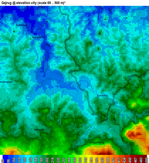
Below is the Elevation map of Gajrug, which displays elevation range with different colors. Scale of the first map is from 69 to 500 m (226 to 1640 ft) with average elevation of 172.7 meters (=567 ft) [note 1]
These maps also provides idea of topography and contour of this city, they are displayed at different zoom levels. More info about maps, scale and edge coordinates you can find below images.
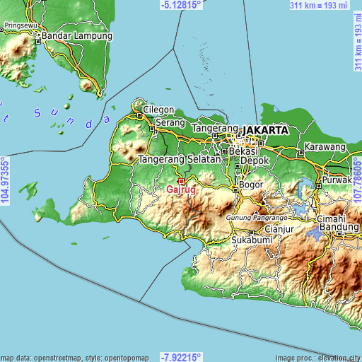
| \ | Map #1 | Topo.Map |
| Scale [m] | 69..500 m | × |
| Scale [ft] | 226..1640 ft | × |
| Average | 172.7 m = 567 ft | × |
| Width | 9.71 km = 6 mi | 310.7 km = 193.1 mi |
| Height | 9.71 km = 6 mi | 310.7 km = 193.1 mi |
| ↑Max Latitude | -6.483438° | -5.12815° |
| Latitude at center | -6.5271° | -6.5271° |
| ↓Min Latitude | -6.570759° | -7.92215° |
| ← Min Longitude | 106.335855° | 104.97355° |
| Longitude center | 106.3798° | 106.3798° |
| →Max Longitude | 106.423745° | 107.78605° |
Nearby cities:
Cities around Gajrug sort by population:
• Ciampea elevation 147 m
35.6 km,  94°
94°
• Curug 39 m
35 km,  33°
33°
• Cikupa 30 m
35.3 km,  23°
23°
• Rangkasbitung 27 m
23.6 km,  322°
322°
• Kadugedong 118 m
35.8 km,  300°
300°
• Warungbanten 608 m
34.4 km,  189°
189°
• Gunungkencana 278 m
34.1 km,  261°
261°
• Sajir 119 m
32.6 km,  273°
273°
• Bojongmanik Girang 110 m
24.4 km,  254°
254°
• Leuwidamar 43 m
20.7 km, 274°
• Muncang 138 m
10 km, 258°
• Sumandang 107 m
6 km,  291°
291°
Multilingual:
 En español:
Gajrug elevación 138 m.
 En France:
Gajrug élévation 138 m.


Sources and notes:
- [note 1] Map square and city borders are not equal. Map elevation data is calculated only from area inside that square.
- [src 1] Elevation data from geonames database provided with same terms of usage.
- [src 2] The elevation map of Gajrug is generated using elevation data from NASA's 3 arcsec (90m) resolution SRTM data.
- [src 3] Base (background) map © OpenStreetMap contributors tiles are generated by Geofabrik and OpenTopoMap.
Copyright & License:
This Gajrug Elevation Map is licensed under CC BY-SA. You may reuse any part from this page, if you give a proper credit by linking to this URL:
 More info on terms of use page.