Karangarjo elevation
Karangarjo (East Java), Indonesia elevation is 301 meters and Karangarjo elevation in feet is 988 ft above sea level [src 1]. Karangarjo is a seat of a third-order administrative division (feature code) with elevation that is 110 meters (361 ft) bigger than average city elevation in Indonesia.
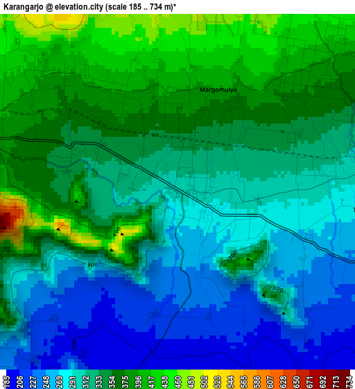
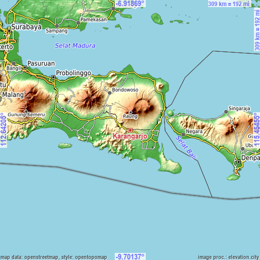
Below is the Elevation map of Karangarjo, which displays elevation range with different colors. Scale of the first map is from 185 to 734 m (607 to 2408 ft) with average elevation of 326.6 meters (=1072 ft) [note 1]
These maps also provides idea of topography and contour of this city, they are displayed at different zoom levels. More info about maps, scale and edge coordinates you can find below images.
| \ | Map #1 | Topo.Map |
| Scale [m] | 185..734 m | × |
| Scale [ft] | 607..2408 ft | × |
| Average | 326.6 m = 1072 ft | × |
| Width | 9.67 km = 6 mi | 309.4 km = 192.3 mi |
| Height | 9.67 km = 6 mi | 309.4 km = 192.3 mi |
| ↑Max Latitude | -8.269014° | -6.91869° |
| Latitude at center | -8.3125° | -8.3125° |
| ↓Min Latitude | -8.355981° | -9.70137° |
| ← Min Longitude | 114.004355° | 112.64205° |
| Longitude center | 114.0483° | 114.0483° |
| →Max Longitude | 114.092245° | 115.45455° |
Nearby cities:
Cities around Karangarjo sort by population:
• Genteng elevation 172 m
12.7 km,  118°
118°
• Srono 60 m
25.9 km,  112°
112°
• Singojuruh 157 m
20.4 km,  91°
91°
• Gambiran Satu 143 m
14.1 km,  129°
129°
• Mayang 177 m
31.6 km,  298°
298°
• Sumberjambe 490 m
31.5 km,  328°
328°
• Purwoharjo 59 m
28.4 km,  137°
137°
• Siliragung 28 m
28.1 km,  165°
165°
• Ledokombo 391 m
27.5 km,  316°
316°
• Sumberan 58 m
26.1 km, 111°
• Sumberjati 383 m
23.2 km,  306°
306°
• Songgon 348 m
19.2 km,  63°
63°
Multilingual:
 En español:
Karangarjo elevación 301 m.
 En France:
Karangarjo élévation 301 m.
 Auf Deutsch:
Karangarjo höhe über dem Meeresspiegel ist 301 m.

Sources and notes:
- [note 1] Map square and city borders are not equal. Map elevation data is calculated only from area inside that square.
- [src 1] Elevation data from geonames database provided with same terms of usage.
- [src 2] The elevation map of Karangarjo is generated using elevation data from NASA's 3 arcsec (90m) resolution SRTM data.
- [src 3] Base (background) map © OpenStreetMap contributors tiles are generated by Geofabrik and OpenTopoMap.
Copyright & License:
This Karangarjo Elevation Map is licensed under CC BY-SA. You may reuse any part from this page, if you give a proper credit by linking to this URL:
 More info on terms of use page.