Katabu elevation
Katabu (Southeast Sulawesi), Indonesia elevation is 63 meters and Katabu elevation in feet is 207 ft above sea level [src 1]. Katabu is a populated place (feature code) with elevation that is 128 meters (420 ft) smaller than average city elevation in Indonesia.
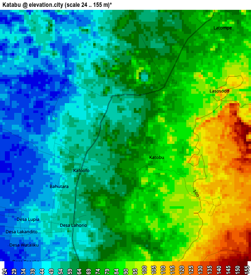
Below is the Elevation map of Katabu, which displays elevation range with different colors. Scale of the first map is from 24 to 155 m (79 to 509 ft) with average elevation of 68.2 meters (=224 ft) [note 1]
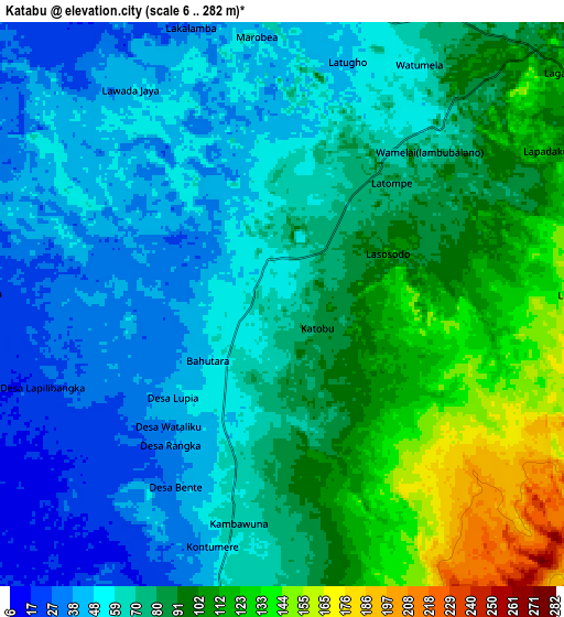
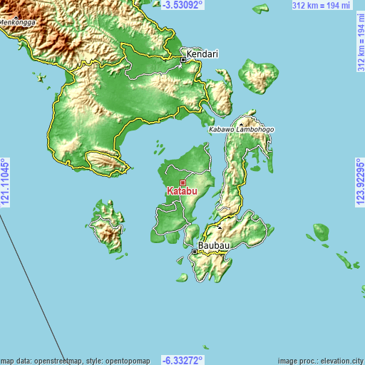
These maps also provides idea of topography and contour of this city, they are displayed at different zoom levels. More info about maps, scale and edge coordinates you can find below images.
| \ | Map #1 | Map #2 | Topo.Map |
| Scale [m] | 24..155 m | 6..282 m | × |
| Scale [ft] | 79..509 ft | 20..925 ft | × |
| Average | 68.2 m = 224 ft | 75.5 m = 248 ft | × |
| Width | 9.74 km = 6.1 mi | 19.47 km = 12.1 mi | 311.5 km = 193.6 mi |
| Height | 9.74 km = 6.1 mi | 19.47 km = 12.1 mi | 311.6 km = 193.6 mi |
| ↑Max Latitude | -4.889516° | -4.845729° | -3.53092° |
| Latitude at center | -4.9333° | -4.9333° | -4.9333° |
| ↓Min Latitude | -4.977081° | -5.020859° | -6.33272° |
| ← Min Longitude | 122.472755° | 122.428809° | 121.11045° |
| Longitude center | 122.5167° | 122.5167° | 122.5167° |
| →Max Longitude | 122.560645° | 122.604591° | 123.92295° |
Nearby cities:
Cities around Katabu sort by population:
• Kendari elevation 2 m
106.2 km,  359°
359°
• Wanci 8 m
121.4 km,  111°
111°
• Langara 4 m
113.9 km,  27°
27°
• Andoolo 95 m
73.5 km,  336°
336°
• Batauga 22 m
73.4 km,  173°
173°
• Pasar Wajo 27 m
72.3 km,  149°
149°
• Rumbia 3 m
66.1 km,  300°
300°
• Buranga 61 m
53.7 km,  74°
74°
• Labungkari 25 m
36.9 km, 174°
• Raha 19 m
25 km,  64°
64°
• Laworo 29 m
16.7 km,  3°
3°
• Lasehao 46 m
8.5 km,  196°
196°
Multilingual:
 En español:
Katabu elevación 63 m.
 En France:
Katabu élévation 63 m.


Sources and notes:
- [note 1] Map square and city borders are not equal. Map elevation data is calculated only from area inside that square.
- [src 1] Elevation data from geonames database provided with same terms of usage.
- [src 2] The elevation map of Katabu is generated using elevation data from NASA's 3 arcsec (90m) resolution SRTM data.
- [src 3] Base (background) map © OpenStreetMap contributors tiles are generated by Geofabrik and OpenTopoMap.
Copyright & License:
This Katabu Elevation Map is licensed under CC BY-SA. You may reuse any part from this page, if you give a proper credit by linking to this URL:
 More info on terms of use page.