Lasem elevation
Lasem (Central Java), Indonesia elevation is 12 meters and Lasem elevation in feet is 39 ft above sea level [src 1]. Lasem is a seat of a third-order administrative division (feature code) with elevation that is 179 meters (587 ft) smaller than average city elevation in Indonesia.
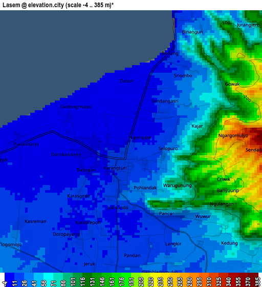
Below is the Elevation map of Lasem, which displays elevation range with different colors. Scale of the first map is from -4 to 385 m (-13 to 1263 ft) with average elevation of 55.5 meters (=182 ft) [note 1]
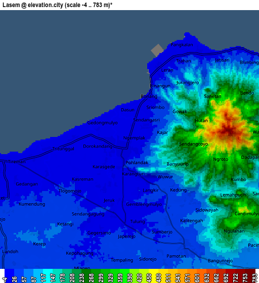
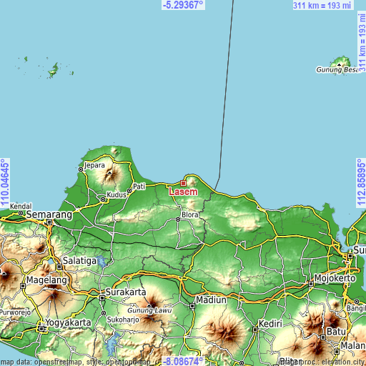
These maps also provides idea of topography and contour of this city, they are displayed at different zoom levels. More info about maps, scale and edge coordinates you can find below images.
| \ | Map #1 | Map #2 | Topo.Map |
| Scale [m] | -4..385 m | -4..783 m | × |
| Scale [ft] | -13..1263 ft | -13..2569 ft | × |
| Average | 55.5 m = 182 ft | 100 m = 328 ft | × |
| Width | 9.71 km = 6 mi | 19.41 km = 12.1 mi | 310.6 km = 193 mi |
| Height | 9.71 km = 6 mi | 19.41 km = 12.1 mi | 310.6 km = 193 mi |
| ↑Max Latitude | -6.648552° | -6.6049° | -5.29367° |
| Latitude at center | -6.6922° | -6.6922° | -6.6922° |
| ↓Min Latitude | -6.735844° | -6.779484° | -8.08674° |
| ← Min Longitude | 111.408755° | 111.364809° | 110.04645° |
| Longitude center | 111.4527° | 111.4527° | 111.4527° |
| →Max Longitude | 111.496645° | 111.540591° | 112.85895° |
Nearby cities:
Cities around Lasem sort by population:
• Rembangan elevation 11 m
12.3 km,  264°
264°
• Kalipang 7 m
22.5 km,  99°
99°
• Bulu 151 m
19.2 km,  195°
195°
• Kragan 6 m
17.6 km,  89°
89°
• Sedan 37 m
15.8 km,  121°
121°
• Sulang Tengah 55 m
15 km,  212°
212°
• Gunem 56 m
12.8 km,  173°
173°
• Sidowayah Kidul 21 m
12.1 km, 255°
• Rembang 11 m
11.5 km, 261°
• Pamotan 36 m
8.7 km,  151°
151°
• Sluke 15 m
8.4 km,  37°
37°
• Pancur 24 m
3.7 km, 151°
Multilingual:
 En español:
Lasem elevación 12 m.
 En France:
Lasem élévation 12 m.


Sources and notes:
- [note 1] Map square and city borders are not equal. Map elevation data is calculated only from area inside that square.
- [src 1] Elevation data from geonames database provided with same terms of usage.
- [src 2] The elevation map of Lasem is generated using elevation data from NASA's 3 arcsec (90m) resolution SRTM data.
- [src 3] Base (background) map © OpenStreetMap contributors tiles are generated by Geofabrik and OpenTopoMap.
Copyright & License:
This Lasem Elevation Map is licensed under CC BY-SA. You may reuse any part from this page, if you give a proper credit by linking to this URL:
 More info on terms of use page.